More small and medium-sized gliding avalanches and snow slides are possible in all altitude zones. Areas with glide cracks are to be avoided.
As a consequence of new snow and a gathering strong westerly wind, mostly small wind slabs will form towards the evening. Individual avalanche prone locations are to be found especially on very steep shady slopes above approximately 2400 m. Caution is to be exercised in particular adjacent to ridgelines.
Snowpack
dp.2: gliding snow
The snowpack is largely stable. The weather conditions gave rise to moistening of the snowpack below approximately 2200 m. As a consequence of new snow and a gathering strong westerly wind, mostly small wind slabs will form towards the evening. A lot of snow is lying for the time of year.
Tendency
The avalanche danger will persist. As a consequence of new snow and a strong to storm force westerly wind, further wind slabs will form.
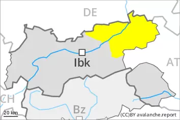
Danger level
2200m
Avalanche Problem
Persistent weak layer
2200m
Gliding snow
2400m
Wind slab
2400m
Weakly bonded old snow and gliding snow require caution.
Weak layers in the old snowpack can be released especially by large additional loads in particular at transitions from a shallow to a deep snowpack, when entering gullies and bowls for example. This applies on very steep slopes above approximately 2200 m. Avalanches can reach large size in isolated cases. Meticulous route selection is recommended.
In addition an appreciable danger of gliding avalanches exists. This applies on steep grassy slopes below approximately 2400 m. Areas with glide cracks are to be avoided.
The fresh wind slabs are prone to triggering in particular on northwest to north to southeast facing aspects above approximately 2400 m. Caution is to be exercised in particular adjacent to ridgelines.
Snowpack
dp.4: cold following warm / warm following cold dp.2: gliding snow
Faceted weak layers exist in the centre of the snowpack in particular above approximately 2200 m. The fresh wind slabs are lying on soft layers in particular on near-ridge shady slopes at high altitudes and in high Alpine regions. The weather conditions gave rise to moistening of the snowpack below approximately 2200 m. As a consequence of new snow and a gathering strong westerly wind, further wind slabs will form towards the evening. During the course of the night these will increase in size moderately.
Tendency
The avalanche danger will persist. As a consequence of new snow and a strong to storm force westerly wind, further wind slabs will form.
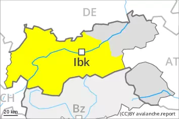
Danger level
2400m
Avalanche Problem
Persistent weak layer
2400m
Wind slab
2400m
Wind slabs and weakly bonded old snow require caution.
Weak layers in the old snowpack can be released especially by large additional loads in particular at transitions from a shallow to a deep snowpack, when entering gullies and bowls for example. This applies on very steep slopes above approximately 2400 m. Avalanches can reach large size in isolated cases.
The fresh and older wind slabs are in some cases prone to triggering in particular on northwest to north to southeast facing aspects above approximately 2400 m. Caution is to be exercised in particular adjacent to ridgelines.
On steep grassy slopes more small and, in isolated cases, medium-sized gliding avalanches are possible. This applies in particular in the regions with a lot of snow.
Snowpack
dp.7: snow-poor zones in snow-rich surrounding dp.6: cold, loose snow and wind
Faceted weak layers exist in the centre of the snowpack in particular above approximately 2400 m. The fresh and somewhat older wind slabs are lying on soft layers in particular on shady slopes at elevated altitudes. The new snow and wind slabs are lying on a crust below approximately 2600 m. As a consequence of new snow and wind the wind slabs will increase in size moderately towards the evening. Towards its base, the snowpack is moist, in particular below approximately 2400 m.
Tendency
The avalanche danger will persist. As a consequence of new snow and a strong to storm force wind from northwesterly directions, further wind slabs will form.
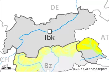
Danger level
2400m
Avalanche Problem
Wind slab
2400m
Wind slabs require caution.
Fresh and somewhat older wind slabs remain in some cases prone to triggering above approximately 2400 m. Avalanche prone locations are to be found in particular adjacent to ridgelines and in gullies and bowls, and behind abrupt changes in the terrain. In isolated cases avalanches are medium-sized.
Snowpack
dp.6: cold, loose snow and wind
The fresh and somewhat older wind slabs are lying on soft layers in particular on shady slopes at elevated altitudes. The old snowpack is largely stable. The new snow and wind slabs are lying on a crust below approximately 2600 m. In steep terrain there is a danger of falling on the icy crust. The snowpack will be subject to considerable local variations. Snow depths vary greatly above the tree line, depending on the infuence of the wind.
From a snow sport perspective, in most cases insufficient snow is lying.