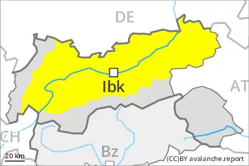
Gliding snow requires caution. Afternoon: Increase in avalanche danger as a consequence of new snow and strong wind.
A substantial danger of gliding avalanches exists. This applies in particular on very steep sunny slopes below approximately 2400 m. Areas with glide cracks are to be avoided as far as possible. As the snowfall becomes more intense more frequent gliding avalanches are possible.
As a consequence of snowfall and the occasionally strong northwesterly wind, fresh snow drift accumulations will form from early morning. Avalanches can be released by a single winter sport participant and reach medium size. As a consequence of new snow and strong wind the prevalence and size of the avalanche prone locations will increase in the afternoon.
Snowpack
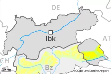
dp.6: cold, loose snow and wind dp.2: gliding snow
The wind will be strong to storm force over a wide area. Over a wide area 20 to 30 cm of snow, and up to 40 cm in some localities, will fall from the afternoon. The fresh snow and the wind slabs that are forming over a wide area will be deposited on soft layers in particular on shady slopes. Towards its base, the snowpack is faceted.
Tendency
Further increase in avalanche danger as the precipitation becomes more intense.
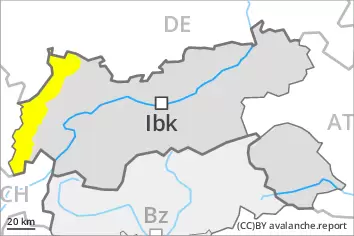
Danger level
2400m
Avalanche Problem
Wind slab
2400m
Gliding snow
2400m
Fresh wind slabs require caution. Gliding snow represents the main danger.
The fresh wind slabs are in isolated cases prone to triggering especially on very steep shady slopes above approximately 2400 m. These can especially at their margins be released by a single winter sport participant and reach medium size. The avalanche prone locations are easy to recognise. Caution is to be exercised in particular in gullies and bowls, and behind abrupt changes in the terrain.
A certain danger of gliding avalanches exists. This applies on steep east, south and west facing slopes below approximately 2400 m. Areas with glide cracks are to be avoided as far as possible.
Weak layers in the old snowpack can be released especially by large additional loads in particular at transitions from a shallow to a deep snowpack, when entering gullies and bowls for example. Avalanche prone locations are to be found on very steep shady slopes above approximately 2200 m. These places are very rare but are difficult to recognise. Avalanches can reach large size in isolated cases.
Snowpack
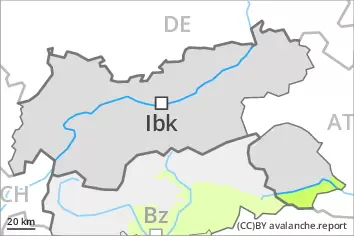
dp.2: gliding snow dp.6: cold, loose snow and wind
The weather conditions gave rise to increasing consolidation of the snowpack. The fresh and somewhat older wind slabs are lying on soft layers in particular on near-ridge shady slopes at high altitudes and in high Alpine regions. This applies in particular on shady slopes. Towards its base, the snowpack is faceted. The snowpack will be generally subject to considerable local variations.
Low and intermediate altitudes: Towards its base, the snowpack is moist.
Evening and first half of night: Over a wide area 10 to 20 cm of snow, and even more in some localities, will fall above approximately 1800 m.
Tendency
Over a wide area 40 to 80 cm of snow, and even more in some localities, will fall on Friday above approximately 1800 m. During the day: Significant increase in avalanche danger as a consequence of new snow and stormy weather. On wind-loaded slopes more frequent natural avalanches are to be expected as the day progresses, even large ones in isolated cases. Gliding avalanches are also to be expected, in particular on steep grassy slopes below approximately 2400 m.
A latent danger of gliding avalanches exists. This applies in particular on very steep sunny slopes below approximately 2400 m. Areas with glide cracks are to be avoided as far as possible.
The fresh snow and the extensive wind slabs that are being formed by the storm force northwesterly wind will become increasingly prone to triggering in all aspects above the tree line. This applies in particular on shady slopes. Caution is to be exercised in particular in gullies and bowls, and behind abrupt changes in the terrain. Avalanches can be released by a single winter sport participant and reach medium size.
Snowpack
dp.6: cold, loose snow and wind dp.2: gliding snow
From midday the wind will be storm force in the vicinity of peaks over a wide area. In some regions up to 15 cm of snow will fall. The sometimes storm force wind will transport the snow. New snow and wind slabs are lying on soft layers. This applies in particular on shady slopes. Towards its base, the snowpack is faceted, especially on shady slopes as well as at high altitudes and in high Alpine regions.
Low and intermediate altitudes: Towards its base, the snowpack is moist.
Tendency
Increase in avalanche danger as a consequence of new snow and strong wind.
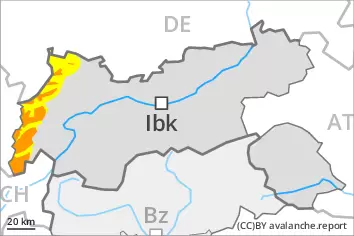
Danger level
2400m
Avalanche Problem
Wind slab
2400m
A quite favourable avalanche situation will prevail. Wind slabs require caution.
The fresh and older wind slabs are in some cases still prone to triggering above approximately 2400 m. Wind slabs can in isolated cases be released by a single winter sport participant and reach medium size. Caution is to be exercised in particular adjacent to ridgelines and in gullies and bowls.
Weak layers in the old snowpack can be released in very isolated cases in particular at transitions from a shallow to a deep snowpack, when entering gullies and bowls for example. This applies on very steep shady slopes above approximately 2400 m. The avalanche prone locations are very rare but are barely recognisable.
In the regions with a lot of snow gliding avalanches are possible.
Snowpack
dp.6: cold, loose snow and wind dp.7: snow-poor zones in snow-rich surrounding
The wind slabs are lying on soft layers in particular on shady slopes at elevated altitudes. Faceted weak layers exist in the centre of the snowpack in particular above approximately 2400 m. The weather conditions gave rise to increasing consolidation of the snowpack. Evening and first half of night: Some snow will fall in some localities.
Tendency
In particular in the north 25 to 50 cm of snow, and even more in some localities, will fall above approximately 1800 m. As the day progresses as a consequence of new snow and stormy weather there will be an appreciable increase in the avalanche danger. The large quantity of fresh snow and in particular the extensive wind slabs represent the main danger. Gliding snow requires caution.
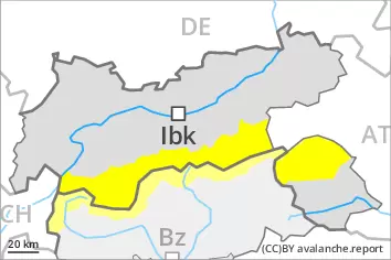
Danger level
2400m
Avalanche Problem
Wind slab
2400m
A generally favourable avalanche situation will prevail. Wind slabs require caution.
The wind slabs are in individual cases still prone to triggering in particular on very steep shady slopes above approximately 2400 m. The mostly small wind slabs are clearly recognisable to the trained eye. Caution is to be exercised in particular adjacent to ridgelines and in gullies and bowls.
Snowpack
dp.6: cold, loose snow and wind
The wind slabs are lying on soft layers in particular on shady slopes at elevated altitudes. The weather conditions will give rise to increasing consolidation of the snowpack. Evening and night: Some snow will fall in some localities.
Tendency
In particular in the north 10 to 20 cm of snow, and even more in some localities, will fall on Friday above approximately 1800 m. As the day progresses as a consequence of new snow and stormy weather there will be an increase in the avalanche danger. Fresh wind slabs require caution.