A quite favourable avalanche situation will prevail. Wind slabs require caution.
The fresh and older wind slabs are in some cases still prone to triggering above approximately 2400 m. Wind slabs can in isolated cases be released by a single winter sport participant and reach medium size. Caution is to be exercised in particular adjacent to ridgelines and in gullies and bowls.
Weak layers in the old snowpack can be released in very isolated cases in particular at transitions from a shallow to a deep snowpack, when entering gullies and bowls for example. This applies on very steep shady slopes above approximately 2400 m. The avalanche prone locations are very rare but are barely recognisable.
In the regions with a lot of snow gliding avalanches are possible.
Snowpack
dp.6: cold, loose snow and wind dp.7: snow-poor zones in snow-rich surrounding
The wind slabs are lying on soft layers in particular on shady slopes at elevated altitudes. Faceted weak layers exist in the centre of the snowpack in particular above approximately 2400 m. The weather conditions gave rise to increasing consolidation of the snowpack. Evening and first half of night: Some snow will fall in some localities.
Tendency
In particular in the north 25 to 50 cm of snow, and even more in some localities, will fall above approximately 1800 m. As the day progresses as a consequence of new snow and stormy weather there will be an appreciable increase in the avalanche danger. The large quantity of fresh snow and in particular the extensive wind slabs represent the main danger. Gliding snow requires caution.
Danger level
A generally favourable avalanche situation will prevail. Wind slabs require caution.
The wind slabs are small and can only be released in isolated cases. Individual avalanche prone locations are to be found in particular adjacent to ridgelines and in gullies and bowls, and behind abrupt changes in the terrain, especially on very steep shady slopes at elevated altitudes.
Snowpack
Snow depths vary greatly above the tree line, depending on the infuence of the wind. As a consequence of new snow and a strong to storm force wind, further wind slabs will form.
Tendency
Some snow will fall. The avalanche danger will increase but remain within the current danger level.
Danger level
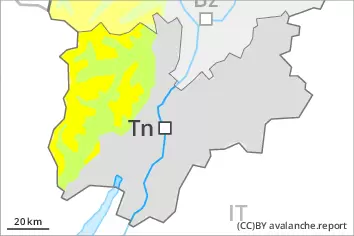
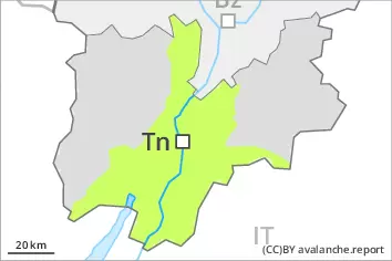
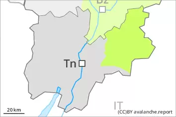
2400m
Avalanche Problem
Wind slab
2400m
A generally favourable avalanche situation will prevail. Wind slabs require caution.
The wind slabs are in individual cases still prone to triggering in particular on very steep shady slopes above approximately 2400 m. The mostly small wind slabs are clearly recognisable to the trained eye. Caution is to be exercised in particular adjacent to ridgelines and in gullies and bowls.
Snowpack
dp.6: cold, loose snow and wind
The wind slabs are lying on soft layers in particular on shady slopes at elevated altitudes. The weather conditions will give rise to increasing consolidation of the snowpack. Evening and night: Some snow will fall in some localities.
Tendency
In particular in the north 10 to 20 cm of snow, and even more in some localities, will fall on Friday above approximately 1800 m. As the day progresses as a consequence of new snow and stormy weather there will be an increase in the avalanche danger. Fresh wind slabs require caution.