Wind slabs are to be evaluated with care and prudence. Some snow will fall.
Old wind slabs can be released in isolated cases, but mostly only by large additional loads, in particular on very steep shady slopes above approximately 2400 m. As a consequence of snowfall and the moderate southwesterly wind, fresh snow drift accumulations will form. Individual avalanche prone locations are to be found adjacent to ridgelines and in gullies and bowls. This applies in particular on steep shady slopes. Avalanches can reach medium size in isolated cases. The avalanche danger will increase during the day. In steep terrain there is a danger of falling on the hard snow surface.
Snowpack
dp.6: cold, loose snow and wind
Snow depths vary greatly above approximately 2400 m, depending on the infuence of the wind. Up to 15 cm of snow will fall from the afternoon above approximately 1500 m. The somewhat older wind slabs will be covered with new snow in some cases and therefore difficult to recognise. Towards its base, the snowpack is faceted.
Tendency
The avalanche danger will persist.
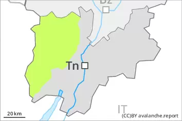
AM Danger level
2400m
Avalanche Problem
Wind slab
2400m
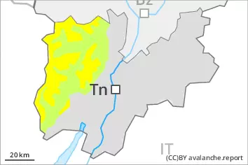
PM Danger level
2400m
Avalanche Problem
Wind slab
2400m
Wind slabs are to be evaluated with care and prudence. Some snow will fall.
Old wind slabs can be released in isolated cases, but mostly only by large additional loads, in particular on very steep shady slopes above approximately 2400 m. As a consequence of snowfall and the moderate southwesterly wind, fresh snow drift accumulations will form. Individual avalanche prone locations are to be found adjacent to ridgelines and in gullies and bowls. This applies in particular on steep shady slopes. Avalanches can reach medium size in isolated cases. The avalanche danger will increase a little during the day. In steep terrain there is a danger of falling on the hard snow surface.
Snowpack
dp.6: cold, loose snow and wind
Snow depths vary greatly above approximately 2400 m, depending on the infuence of the wind. Up to 15 cm of snow will fall from the afternoon above approximately 1500 m. The somewhat older wind slabs will be covered with new snow in some cases and therefore difficult to recognise. Towards its base, the snowpack is faceted.
Tendency
The avalanche danger will persist.
Danger level
Wind slabs are to be evaluated with care and prudence. Some snow will fall.
In all regions only a little snow is lying. As a consequence of snowfall and the moderate southwesterly wind, fresh snow drift accumulations will form. The avalanche danger will increase a little during the day.
Snowpack
dp.6: cold, loose snow and wind
The snowpack will be quite stable. Snow depths vary greatly above the tree line, depending on the infuence of the wind. The somewhat older wind slabs will be covered with new snow in some cases and therefore difficult to recognise. Up to 15 cm of snow will fall from the afternoon above approximately 1500 m.