As a consequence of the occasionally strong wind, fresh snow drift accumulations will form. These are prone to triggering at elevated altitudes. Caution is to be exercised in particular adjacent to ridgelines in gullies and bowls, and behind abrupt changes in the terrain above approximately 2200 m. The number and size of avalanche prone locations will increase with altitude. These avalanche prone locations are easy to recognise.
In addition a latent danger of gliding avalanches exists, in particular on steep east, south and west facing slopes below approximately 2600 m. Gliding avalanches can be released at any time of day or night. In isolated cases they are quite large. This applies in the regions with a lot of snow. Caution is to be exercised in areas with glide cracks.
Snowpack
dp.6: cold, loose snow and wind dp.2: gliding snow
Friday: Evening and night: Over a wide area 10 to 20 cm of snow will fall. The wind will be moderate to strong over a wide area. The fresh wind slabs are lying on soft layers at elevated altitudes. The fresh wind slabs can in some cases be released easily.
The new snow is lying on a crust in all aspects below approximately 2600 m. Low and intermediate altitudes: The old snowpack is fairly homogeneous and its surface has a melt-freeze crust that is strong in many cases. This also applies on steep sunny slopes at high altitude.
The old snowpack will be stable over a wide area.
Tendency
Over a wide area 20 to 40 cm of snow will fall until Sunday above approximately 1000 m. Slight increase in avalanche danger as a consequence of new snow and wind. Fresh wind slabs require caution. A latent danger of gliding avalanches exists.
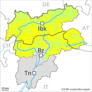
AM Danger level
2200m
Avalanche Problem
Wind slab
2200m
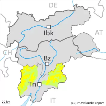
PM Danger level
treeline
Avalanche Problem
New snow
Treeline
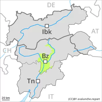
Wind slab
Treeline
During the day: New snow and wind slabs require caution.
Afternoon: The new snow represents the main danger. This snow can be released easily, or, in isolated cases, naturally in all aspects at intermediate and high altitudes. As a consequence of snowfall and the strong wind, fresh snow drift accumulations formed. These can be released by a single winter sport participant in isolated cases above the tree line. At high altitude these avalanche prone locations are more prevalent. Caution is to be exercised in particular at transitions from a shallow to a deep snowpack, as well as in gullies and bowls, and behind abrupt changes in the terrain.
Snowpack
dp.6: cold, loose snow and wind
Afternoon: Over a wide area over a wide area 20 to 30 cm of snow, and even more in some localities, will fall above approximately 1500 m. Snow depths vary greatly above the tree line, depending on the infuence of the wind. The fresh wind slabs are bonding poorly with the old snowpack in all aspects and above the tree line.
Tendency
New snow and wind slabs require caution. The avalanche danger will increase.
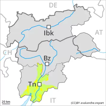
AM Danger level
PM Danger level
treeline
Avalanche Problem
New snow
Treeline
Wind slab
Treeline
New snow and wind slabs require caution. During the day:
During the day: The new snow represents the main danger. Can be released easily, or, in isolated cases, naturally in all aspects above the tree line. As a consequence of the strong wind, fresh snow drift accumulations formed. At high altitude these avalanche prone locations are more prevalent. Individual avalanche prone locations are to be found in shady places that are protected from the wind and in gullies and bowls, and behind abrupt changes in the terrain. Caution is to be exercised in particular at transitions from a shallow to a deep snowpack, as well as in gullies and bowls, and behind abrupt changes in the terrain.
Snowpack
Afternoon: Over a wide area over a wide area 20 to 30 cm of snow, and even more in some localities, will fall above approximately 1500 m. Snow depths vary greatly above the tree line, depending on the infuence of the wind. The fresh wind slabs are bonding poorly with the old snowpack in all aspects and above the tree line. At low altitude only a little snow is lying.
Tendency
New snow and wind slabs require caution. The avalanche danger will increase.
Danger level
The conditions are generally favourable. Fresh wind slabs require caution.
In some places small wind slabs formed. The fresh wind slabs can be released in isolated cases on steep shady slopes in high Alpine regions. The avalanche prone locations are rare and are easy to recognise. In steep terrain there is a danger of falling on the hard snow surface.
Snowpack
dp.6: cold, loose snow and wind
In some regions up to 10 cm of snow has fallen above approximately 1000 m. The strong wind has transported the new snow. The old snowpack will be stable over a wide area.
Low and intermediate altitudes: The snowpack is wet all the way through and its surface has a melt-freeze crust that is strong in many cases.