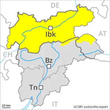
As a consequence of new snow and a strong wind from northwesterly directions, extensive wind slabs formed at elevated altitudes. Even single winter sport participants can release avalanches in some places, including medium-sized ones. Avalanche prone locations are to be found on wind-loaded slopes above approximately 2400 m and adjacent to ridgelines and in gullies and bowls. At elevated altitudes the likelihood of avalanches being released is greater.
More gliding avalanches are possible, even large ones in isolated cases. This applies in particular on steep grassy slopes below approximately 2600 m. Areas with glide cracks are to be avoided. On extremely steep slopes mostly small loose snow avalanches are to be expected as a consequence of solar radiation.
Snowpack
dp.6: cold, loose snow and wind dp.2: gliding snow
Friday: Evening: 5 to 10 cm of snow, and even more in some localities, has fallen.
The northwesterly wind will transport the new snow. This applies at high altitudes and in high Alpine regions. Avalanche prone weak layers exist in the top section of the snowpack. Towards its base, the snowpack is largely stable. Low and intermediate altitudes: The high temperatures gave rise to significant moistening of the snowpack.
Tendency
Wind slabs and gliding snow require caution.
Danger level
treeline
Avalanche Problem
Wind slab
Treeline
Wet snow
2700m
Treeline
The wind slabs of the last few days represent the main danger. The weather will be mild in the regions exposed to the foehn wind.
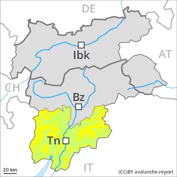
As a consequence of high temperatures, solar radiation and the moderate to strong northerly foehn wind, a treacherous avalanche situation will develop on Saturday. In addition the fresh and older wind slabs must be taken into account. These can be released even by a single winter sport participant. The avalanche prone locations are to be found in particular adjacent to ridgelines and in gullies and bowls in all aspects. In addition by the evening in particular at the base of rock walls and behind abrupt changes in the terrain, further small and medium-sized natural avalanches are possible.
Snowpack
More recent wind slabs are poorly bonded with the old snowpack above the tree line. The spring-like weather conditions gave rise to moistening of the snowpack below approximately 2700 m. As a consequence of mild temperatures and the moderate to strong northwesterly wind, the snow drift accumulations have increased in size during the last few days. Snow depths vary greatly, depending on the infuence of the wind.
Tendency
The avalanche danger will persist.
Danger level
2400m
Avalanche Problem
Wind slab
2400m
Gliding snow
2600m
Wind slabs and gliding snow require caution.
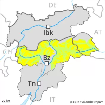
As a consequence of a sometimes strong wind from northwesterly directions, sometimes avalanche prone wind slabs will form on north and east facing slopes. Avalanche prone locations are to be found in gullies and bowls, and behind abrupt changes in the terrain above approximately 2400 m. At elevated altitudes the avalanche prone locations are a little more prevalent and exist in all aspects. Avalanches can in some cases reach medium size.
More gliding avalanches are possible, even quite large ones, in particular on steep east, south and west facing slopes below approximately 2600 m, in particular in the regions with a lot of snow. Areas with glide cracks are to be avoided. On extremely steep slopes more small to medium-sized wet loose snow avalanches are possible as a consequence of warming during the day and solar radiation.
Snowpack
dp.6: cold, loose snow and wind dp.2: gliding snow
Some snow has fallen in particular in the north. Up to intermediate altitudes rain has fallen.
High altitudes and the high Alpine regions: The northwesterly wind will transport the new snow and, in some cases, old snow as well. The fresh wind slabs will be deposited on soft layers at elevated altitudes. They are in some cases prone to triggering. Towards its base, the snowpack consists of faceted crystals. The snowpack will be subject to considerable local variations above the tree line.
Intermediate altitudes: Early and late morning: The snowpack is wet and its surface has a melt-freeze crust.
Tendency
Wind slabs and gliding snow represent the main danger.
Danger level
treeline
Avalanche Problem
Wind slab
Treeline
Wind slabs require caution. Moist snow slides are possible during the day.
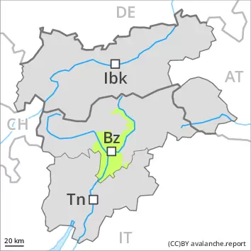
The fresh and somewhat older wind slabs can be released in isolated cases, especially at their margins. Caution is to be exercised in particular adjacent to ridgelines in gullies and bowls, and behind abrupt changes in the terrain. Mostly avalanches are small.
As a consequence of warming during the day and solar radiation gliding avalanches and moist snow slides are possible, but they will be mostly small.
Snowpack
dp.6: cold, loose snow and wind dp.10: springtime scenario
Wind slabs are lying on soft layers in particular on steep shady slopes. The old snowpack will be quite stable. Early and late morning: The snowpack is moist and its surface has a melt-freeze crust.