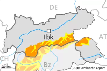
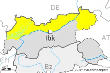
Fresh wind slabs represent the main danger. Weakly bonded old snow requires caution.
The new snow and wind slabs can be released easily, even by a single winter sport participant, above the tree line. Individual natural avalanches are possible, especially in the Ultental and in the Ortler Range. The number and size of avalanche prone locations will increase with altitude. Avalanches can in some cases reach quite a large size.
Weak layers in the old snowpack can be released in some places even by individual winter sport participants. The avalanche prone locations are to be found in particular on west, north and east facing slopes above approximately 2400 m. Avalanches can reach large size in isolated cases.
As a consequence of warming small to medium-sized loose snow avalanches are possible. In particular in the regions with a lot of snow more frequent small and medium-sized gliding avalanches are possible, especially below approximately 2600 m.
Snowpack
dp.6: cold, loose snow and wind dp.4: cold following warm / warm following cold
Over a wide area 15 to 25 cm of snow, and up to 40 cm in some localities, will fall on Tuesday. As a consequence of new snow and wind the wind slabs will increase in size appreciably. They are prone to triggering.
Avalanche prone weak layers exist deeper in the snowpack in particular on steep east, north and west facing slopes.
Tendency
The conditions will facilitate a gradual stabilisation of the snow drift accumulations. The high humditiy will give rise to increasing moistening of the snowpack also at elevated altitudes. Gliding avalanches and moist snow slides are to be expected.
Danger level
treeline
Avalanche Problem
Wind slab
Treeline
Persistent weak layer
2400m
Gliding snow
2600m
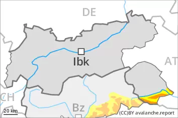
Fresh wind slabs represent the main danger. Weakly bonded old snow requires caution.
The new snow and wind slabs can be released easily, even by a single winter sport participant, above the tree line. The number and size of avalanche prone locations will increase with altitude. Mostly avalanches are medium-sized.
Weak layers in the old snowpack can be released in some places even by individual winter sport participants. The avalanche prone locations are to be found in particular on west, north and east facing slopes above approximately 2400 m. Avalanches can reach large size in isolated cases.
As a consequence of warming small to medium-sized loose snow avalanches are possible. In particular in the regions with a lot of snow more frequent small and medium-sized gliding avalanches are possible, especially below approximately 2600 m.
Snowpack
dp.6: cold, loose snow and wind dp.4: cold following warm / warm following cold
Over a wide area 15 to 25 cm of snow will fall on Tuesday. As a consequence of new snow and wind the wind slabs will increase in size appreciably. They are prone to triggering.
Avalanche prone weak layers exist deeper in the snowpack in particular on steep east, north and west facing slopes.
Tendency
The conditions will facilitate a gradual stabilisation of the snow drift accumulations. The high humditiy will give rise to increasing moistening of the snowpack also at elevated altitudes. Gliding avalanches and moist snow slides are to be expected.
Danger level
treeline
Avalanche Problem
Wind slab
Treeline
Persistent weak layer
2400m
Gliding snow
2600m
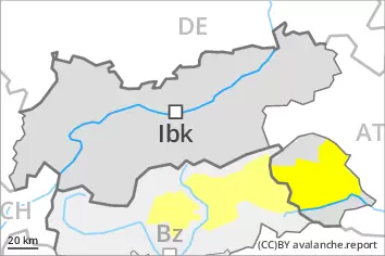
Fresh wind slabs represent the main danger. Weakly bonded old snow requires caution.
The new snow and wind slabs can be released by a single winter sport participant in particular on shady slopes above the tree line. The number and size of avalanche prone locations will increase with altitude. Mostly avalanches are medium-sized.
Weak layers in the old snowpack can be released in some places even by individual winter sport participants. The avalanche prone locations are to be found in particular on west, north and east facing slopes above approximately 2400 m. Avalanches can reach large size in isolated cases.
As a consequence of warming small and, in isolated cases, medium-sized loose snow avalanches are possible. In particular in the regions with a lot of snow more frequent small and medium-sized gliding avalanches are possible, especially below approximately 2600 m.
Snowpack
dp.6: cold, loose snow and wind dp.4: cold following warm / warm following cold
Over a wide area 5 to 15 cm of snow will fall on Tuesday. As a consequence of new snow and wind the wind slabs will increase in size moderately. They are in some cases prone to triggering.
Avalanche prone weak layers exist deeper in the snowpack in particular on steep east, north and west facing slopes.
Tendency
The conditions will facilitate a gradual stabilisation of the snow drift accumulations. The high humditiy will give rise to increasing moistening of the snowpack also at elevated altitudes. Gliding avalanches and moist snow slides are to be expected.
Danger level
treeline
Avalanche Problem
Wind slab
Treeline
Persistent weak layer
2400m
Gliding snow
2600m
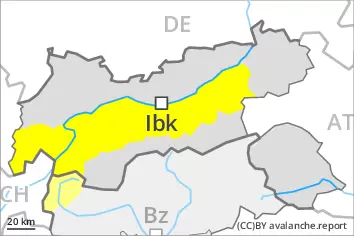
Fresh wind slabs require caution. Weakly bonded old snow is to be evaluated with care and prudence.
As a consequence of new snow and a sometimes strong southerly wind, sometimes avalanche prone wind slabs will form in particular adjacent to ridgelines on north facing slopes. This applies especially above the tree line. Single winter sport participants can release avalanches, including medium-sized ones. The number and size of avalanche prone locations will increase with altitude.
Avalanches can in isolated cases be triggered in the old snowpack and reach large size in isolated cases in particular on very steep west, north and east facing slopes. Such avalanche prone locations are to be found above approximately 2400 m.
As a consequence of warming during the day individual loose snow slides are possible as the day progresses, but they will be mostly small. On steep grassy slopes medium-sized gliding avalanches are possible, especially on sunny slopes below approximately 2600 m.
Snowpack
dp.6: cold, loose snow and wind dp.4: cold following warm / warm following cold
In some regions 5 to 15 cm of snow will fall on Tuesday. The southerly wind will transport the new snow. Fresh wind slabs are lying on soft layers especially on shady slopes.
In isolated cases new snow and wind slabs are lying on a weakly bonded old snowpack, in particular on steep west, north and east facing slopes above approximately 2400 m.
Tendency
The conditions will facilitate a gradual stabilisation of the snow drift accumulations. The high humditiy will give rise to increasing moistening of the snowpack also at elevated altitudes. Gliding avalanches and moist snow slides are to be expected.
On steep grassy slopes mostly small gliding avalanches are possible, in particular below approximately 2600 m.
The fresh wind slabs are in some cases still prone to triggering on very steep shady slopes above the tree line. Avalanches can in isolated cases be released by a single winter sport participant and reach medium size. The prevalence of avalanche prone locations and likelihood of triggering will increase with altitude.
Snowpack
dp.2: gliding snow dp.6: cold, loose snow and wind
The sometimes strong wind has transported the new snow. In some cases wind slabs are lying on soft layers, in particular on shady slopes above the tree line.
Tendency
The wind slabs can be released in isolated cases. In addition gliding avalanches and wet snow slides are possible.