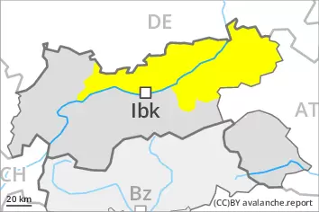
Danger level
 | 2600m |
|  |
|  | ||||
|  |
|  |


![]()
Increase in danger of wet and gliding avalanches. Fresh wind slabs at high altitude.
More frequent wet loose snow avalanches are to be expected, even medium-sized ones. In addition an appreciable danger of gliding avalanches exists, in particular on steep sunny slopes below approximately 2600 m, as well as on steep shady slopes below approximately 2400 m.
The wind slabs of the last few days can be released by a single winter sport participant in some cases in particular on very steep shady slopes above approximately 2400 m. This applies especially adjacent to ridgelines. In some cases avalanches are medium-sized. The number and size of avalanche prone locations will increase with altitude.
Avalanches can in very isolated cases be triggered in the old snowpack and reach large size in isolated cases in particular on very steep west, north and east facing slopes. Such avalanche prone locations are to be found above approximately 2400 m.
Snowpack
dp.2: gliding snow
dp.6: cold, loose snow and wind
In some regions up to 10 cm of snow fell on Friday. Some snow will fall on Saturday in some regions.
The snowpack will be moist below approximately 2400 m. The surface of the snowpack will soften during the day.
Fresh and somewhat older wind slabs are lying on soft layers in particular on shady slopes. This applies at high altitudes and in high Alpine regions. In isolated cases new snow and wind slabs are lying on a weakly bonded old snowpack, in particular on steep west, north and east facing slopes above approximately 2400 m.
Tendency
Gliding avalanches and moist snow slides require caution.
Over a wide area up to 10 cm of snow, and even more in some localities, will fall until Monday. In isolated cases the wind slabs will increase in size.