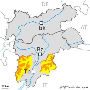
Wind slabs and weakly bonded old snow require caution. Gliding snow requires caution.
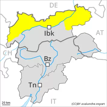
As a consequence of new snow and a sometimes strong southwesterly wind, sometimes avalanche prone wind slabs will form on Saturday. Caution is to be exercised in particular on steep shady slopes, as well as adjacent to ridgelines and in gullies and bowls in particular at elevated altitudes. Weak layers in the upper part of the snowpack can be released by individual winter sport participants. Avalanche prone locations are to be found in particular on steep shady slopes above approximately 2400 m. Places where surface hoar has been covered with snow are especially unfavourable. Avalanches can reach large size in isolated cases. Careful route selection is recommended. In addition a latent danger of gliding avalanches exists, in particular on sunny slopes below approximately 2400 m. These can in isolated cases reach quite a large size. Areas with glide cracks are to be avoided as far as possible.
Snowpack
dp.6: cold, loose snow and wind dp.8: surface hoar blanketed with snow
Over a wide area 10 to 20 cm of snow, and even more in some localities, has fallen since Friday. The wind will be strong at times over a wide area. Fresh wind slabs are lying on soft layers at elevated altitudes. This applies above approximately 2400 m. Faceted weak layers exist in the top section of the old snowpack on west, north and east facing slopes. This applies above approximately 2400 m.
Tendency
Over a wide area 25 to 50 cm of snow, and even more in some localities, will fall on Sunday above approximately 1500 m. Significant increase in avalanche danger as a consequence of new snow and strong wind.
Danger level
2400m
Avalanche Problem
Persistent weak layer
2400m
Wind slab
2200m
Gliding snow
2600m
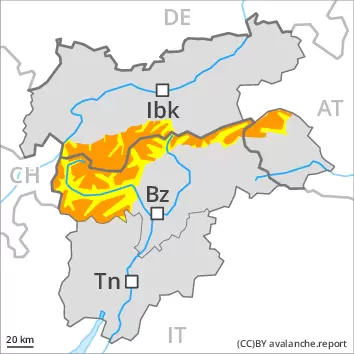
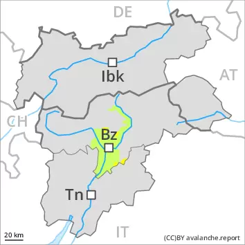
Wind slabs and weakly bonded old snow require caution. This applies above approximately 2400 m.
Weak layers in the upper part of the snowpack can be released by individual winter sport participants. Avalanche prone locations are to be found in particular on steep shady slopes above approximately 2400 m, caution is to be exercised in particular in the regions exposed to heavier precipitation on the Main Alpine Ridge. Places where surface hoar has been covered with snow are especially unfavourable. Avalanches can reach large size in isolated cases. Careful route selection is recommended.
As a consequence of new snow and a sometimes strong southwesterly wind, sometimes avalanche prone wind slabs will form. Caution is to be exercised in particular on very steep shady slopes, as well as adjacent to ridgelines and in pass areas above approximately 2200 m. The prevalence of such avalanche prone locations will increase with altitude. In addition a latent danger of gliding avalanches exists, in particular on steep sunny slopes below approximately 2600 m. These can in isolated cases reach medium size. Areas with glide cracks are to be avoided as far as possible.
Snowpack
dp.8: surface hoar blanketed with snow dp.6: cold, loose snow and wind
Up to 10 cm of snow, and even more in some localities, will fall, especially in the Ultental, in the Texel Mountains and in the Stubai Alps. The new snow of the last few days is lying on surface hoar in particular on wind-protected shady slopes above approximately 2400 m. Fresh wind slabs are lying on soft layers at elevated altitudes.
Faceted weak layers exist in the centre of the old snowpack in particular on west, north and east facing slopes. This applies above approximately 2400 m.
Tendency
Gradual increase in avalanche danger as a consequence of new snow and strong wind. Over a wide area 15 to 30 cm of snow, and even more in some localities, will fall on Sunday.
Danger level
2200m
Avalanche Problem
Wind slab
2200m
Gliding snow
2600m
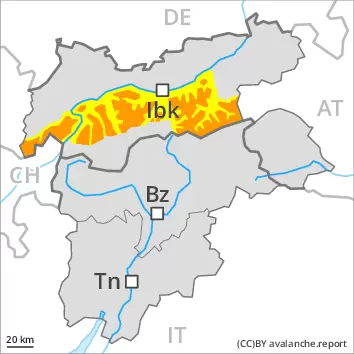
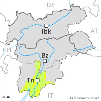
In the regions exposed to the foehn wind strong southerly wind: Fresh wind slabs require caution.
The strong wind will transport the snow. The fresh wind slabs can in some places be released by a single winter sport participant and reach medium size, in particular on shady slopes above approximately 2200 m. Gullies and bowls are especially unfavourable. The prevalence of the avalanche prone locations will increase with altitude.
In addition a latent danger of gliding avalanches exists, in particular on steep sunny slopes below approximately 2600 m. These can reach medium size. Areas with glide cracks are to be avoided as far as possible. As a consequence of warming moist snow slides are possible. This applies in particular at low and intermediate altitudes.
Snowpack
dp.6: cold, loose snow and wind dp.2: gliding snow
Fresh wind slabs are lying on soft layers at elevated altitudes. Isolated avalanche prone weak layers exist in the top section of the old snowpack on west, north and east facing slopes. This applies above approximately 2400 m. Towards its base, the snowpack is largely stable.
The old snowpack will be moist below approximately 2200 m.
Tendency
As a consequence of the strong to storm force foehn wind, fresh snow drift accumulations will form on Sunday.
Danger level
2200m
Avalanche Problem
Wind slab
2200m
Gliding snow
2600m
Fresh wind slabs require caution. Gliding snow at intermediate altitudes.
As a consequence of new snow and a sometimes strong southwesterly wind, wind slabs will form in particular in gullies and bowls and behind abrupt changes in the terrain. These can be released by a single winter sport participant in some cases in particular on shady slopes above approximately 2200 m. Mostly avalanches are medium-sized.
A latent danger of gliding avalanches exists, in particular on steep sunny slopes below approximately 2600 m. These can reach medium size. Areas with glide cracks are to be avoided as far as possible.
Snowpack
dp.6: cold, loose snow and wind dp.2: gliding snow
Some snow will fall. The wind will be strong in some cases. Fresh wind slabs are lying on soft layers at elevated altitudes. The old snowpack will be moist below approximately 2200 m.
Faceted weak layers exist in the top section of the old snowpack on west, north and east facing slopes. This applies above approximately 2400 m.
Tendency
Gradual increase in avalanche danger as a consequence of new snow and strong wind. Over a wide area 10 to 20 cm of snow, and even more in some localities, will fall on Sunday.
Danger level
2200m
Avalanche Problem
Wind slab
2200m
Gliding snow
2600m
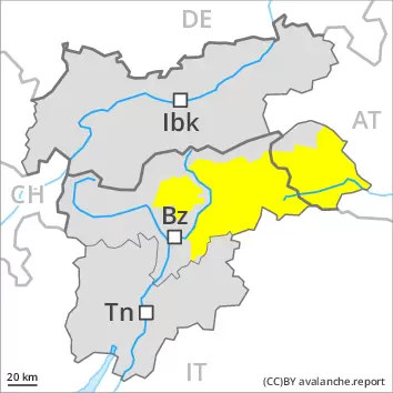
In the regions exposed to the foehn wind strong southerly wind: Fresh wind slabs require caution.
The strong wind will transport the snow. The fresh wind slabs can in isolated cases be released by small loads and reach medium size, in particular on shady slopes above approximately 2200 m.
In addition a latent danger of gliding avalanches exists, in particular on steep sunny slopes below approximately 2600 m. These can reach medium size. Areas with glide cracks are to be avoided as far as possible. As a consequence of warming moist snow slides are possible. This applies in particular at low and intermediate altitudes.
Snowpack
dp.6: cold, loose snow and wind dp.2: gliding snow
Fresh wind slabs are lying on soft layers at elevated altitudes. Isolated avalanche prone weak layers exist in the top section of the old snowpack on west, north and east facing slopes. This applies above approximately 2400 m. Towards its base, the snowpack is largely stable.
The old snowpack will be moist below approximately 2200 m.
Tendency
As a consequence of the strong to storm force foehn wind, fresh snow drift accumulations will form on Sunday.
Danger level
2400m
Avalanche Problem
Wind slab
2400m
Fresh wind slabs require caution.
The fresh wind slabs can be released by a single winter sport participant in isolated cases in particular on steep shady slopes at high altitude. In very isolated cases avalanches are medium-sized.
On steep slopes mostly small gliding avalanches and moist snow slides are possible.
Snowpack
dp.6: cold, loose snow and wind
Up to 10 cm of snow will fall. The wind slabs are in isolated cases prone to triggering.
At low altitude no snow is lying.
Tendency
Gradual increase in avalanche danger as a consequence of new snow and strong wind. Over a wide area 10 to 20 cm of snow, and even more in some localities, will fall on Sunday.
Danger level
treeline
Avalanche Problem
Wind slab
Treeline
Fresh wind slabs require caution.
Wind slabs can be released by a single winter sport participant in isolated cases in particular on steep shady slopes at high altitude. Mostly avalanches are small but can be released easily even by a single winter sport participant. In very isolated cases avalanches are medium-sized. On steep sunny slopes mostly small moist snow slides are possible.
Snowpack
In some regions 10 to 20 cm of snow, and even more in some localities, has fallen since Friday. As a consequence of the moderate to strong wind, fresh snow drift accumulations will form on Saturday. The fresh and somewhat older wind slabs are in isolated cases prone to triggering. At low altitude hardly any snow is lying.
Tendency
Over a wide area 25 to 50 cm of snow, and even more in some localities, will fall on Sunday above approximately 1500 m. Significant increase in avalanche danger as a consequence of new snow and strong wind.