Wind slabs and weakly bonded old snow require caution. The sometimes strong wind will transport the snow.
Avalanches can be triggered in the old snowpack and reach large size in isolated cases. Avalanche prone locations are to be found in particular on steep shady slopes above approximately 2400 m. Individual avalanche prone locations are to be found also on steep southeast, south and southwest facing slopes above approximately 2600 m. Released avalanches and reports filed by observers confirm the unfavourable bonding of the snowpack. Places where surface hoar has been covered with snow are especially unfavourable. Such avalanche prone locations are rather rare and are difficult to recognise.
The new snow and wind slabs can be released by a single winter sport participant in particular on steep shady slopes above approximately 2200 m. As a consequence of the sometimes strong wind the wind slabs will increase in size additionally. Caution is to be exercised in particular adjacent to ridgelines and in gullies and bowls. The prevalence of the avalanche prone locations will increase with altitude. Avalanches can reach medium size.
From origins in starting zones where no previous releases have taken place more gliding avalanches are possible, even large ones in isolated cases. This applies in particular below approximately 2600 m. Caution is to be exercised in areas with glide cracks.
Snowpack
dp.8: surface hoar blanketed with snow dp.6: cold, loose snow and wind
In some regions up to 15 cm of snow fell on Tuesday. 5 to 15 cm of snow will fall on Wednesday. The wind will be moderate to strong over a wide area. The new snow and wind slabs are lying on soft layers in particular on wind-protected shady slopes above approximately 2200 m.
Faceted weak layers exist in the centre of the old snowpack in particular on west, north and east facing slopes. This applies above approximately 2400 m. The new snow and wind slabs are lying on surface hoar in some places in particular on shady slopes.
As a consequence of rising temperatures and solar radiation a crust formed on the surface, in particular on steep sunny slopes in all altitude zones.
Tendency
The fresh and older wind slabs remain prone to triggering in particular on shady slopes at elevated altitudes. More gliding avalanches are possible, in particular medium-sized ones.
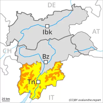
Danger level
treeline
Avalanche Problem
Wind slab
Treeline
Wet snow
2400m
Wind slabs represent the main danger. Gliding avalanches can also occur.
The new snow and wind slabs of the last few days remain for the foreseeable future prone to triggering in all aspects above the tree line. Avalanches can reach large size in isolated cases. The prevalence of the avalanche prone locations will increase with altitude. Caution is to be exercised in particular adjacent to ridgelines and in gullies and bowls, as well as in places that are protected from the wind. As a consequence of warming during the day and solar radiation more slab avalanches are possible as the day progresses, but they can be quite large. In addition medium-sized and, in isolated cases, large gliding avalanches and wet snow slides are possible, in particular on steep sunny slopes below approximately 2400 m. Areas with glide cracks are to be avoided.
Snowpack
dp.6: cold, loose snow and wind dp.10: springtime scenario
Some snow will fall on Wednesday in some regions. On Wednesday the wind will be moderate to strong at times. The new snow and wind slabs of the last few days are lying on soft layers above approximately 2200 m. Sunshine and high temperatures will give rise as the day progresses to moistening of the snowpack in particular at intermediate altitudes. The solar radiation will give rise as the day progresses to gradual moistening of the snowpack in particular on steep sunny slopes at intermediate altitudes. As a consequence of the occasionally strong wind, the snow drift accumulations have increased in size during the last few days.
Tendency
Gradual decrease in danger of dry avalanches as a consequence of warming during the day and solar radiation. Gliding avalanches and wet snow slides are possible on Thursday, even large ones in isolated cases.
Danger level
2400m
Avalanche Problem
Persistent weak layer
2400m
Wind slab
2200m
Wind slabs and weakly bonded old snow require caution. The sometimes strong wind will transport the snow.
Avalanches can be triggered in the old snowpack and reach large size in isolated cases. Avalanche prone locations are to be found in particular on steep shady slopes above approximately 2400 m. Individual avalanche prone locations are to be found also on steep southeast, south and southwest facing slopes above approximately 2600 m. Released avalanches and reports filed by observers confirm the unfavourable bonding of the snowpack. Places where surface hoar has been covered with snow are especially unfavourable. Such avalanche prone locations are rather rare and are difficult to recognise.
The new snow and wind slabs can be released by a single winter sport participant in particular on steep shady slopes above approximately 2200 m. As a consequence of the sometimes strong wind the wind slabs will increase in size additionally. Caution is to be exercised in particular adjacent to ridgelines and in gullies and bowls. The prevalence of the avalanche prone locations will increase with altitude. Avalanches can reach medium size.
From origins in starting zones where no previous releases have taken place more gliding avalanches are possible, even large ones in isolated cases. This applies in particular below approximately 2600 m. Caution is to be exercised in areas with glide cracks.
Snowpack
dp.8: surface hoar blanketed with snow dp.6: cold, loose snow and wind
In particular on the Main Alpine Ridge and to the north 5 to 15 cm of snow, and even more in some localities, will fall. The wind will be moderate to strong over a wide area. The new snow and wind slabs are lying on soft layers in particular on wind-protected shady slopes above approximately 2200 m.
Faceted weak layers exist in the centre of the old snowpack in particular on west, north and east facing slopes. This applies above approximately 2400 m. The new snow and wind slabs are lying on surface hoar in some places in particular on shady slopes.
As a consequence of rising temperatures and solar radiation a crust formed on the surface, in particular on steep sunny slopes in all altitude zones.
Tendency
The fresh and older wind slabs remain prone to triggering in particular on shady slopes at elevated altitudes. Weakly bonded old snow is to be evaluated critically. More gliding avalanches are possible, in particular medium-sized ones.
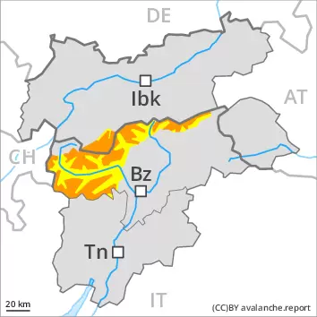
Danger level
2200m
Avalanche Problem
Wind slab
2200m
Gliding snow
2600m
The sometimes strong wind will transport the snow. Fresh wind slabs represent the main danger.
The new snow and wind slabs can be released by a single winter sport participant in particular on steep shady slopes above approximately 2200 m. As a consequence of the sometimes strong wind the wind slabs will increase in size additionally. Avalanches can reach medium size. The prevalence of the avalanche prone locations will increase with altitude. Caution is to be exercised in particular adjacent to ridgelines and in gullies and bowls.
Avalanches can in very isolated cases be triggered in the old snowpack and reach quite a large size. Avalanche prone locations are to be found in particular on steep shady slopes above approximately 2400 m. Places where surface hoar has been covered with snow are especially unfavourable.
From origins in starting zones where no previous releases have taken place more gliding avalanches are possible, even large ones in isolated cases. This applies in particular below approximately 2600 m. Caution is to be exercised in areas with glide cracks.
Snowpack
dp.6: cold, loose snow and wind dp.8: surface hoar blanketed with snow
In particular on the Main Alpine Ridge and to the north 5 to 15 cm of snow, and even more in some localities, will fall. The wind will be moderate to strong over a wide area. The new snow and wind slabs are lying on soft layers in particular on wind-protected shady slopes above approximately 2200 m.
Faceted weak layers exist in the centre of the old snowpack in particular on west, north and east facing slopes. This applies above approximately 2400 m. The new snow and wind slabs are lying on surface hoar in some places in particular on shady slopes.
As a consequence of rising temperatures and solar radiation a crust formed on the surface, in particular on steep sunny slopes in all altitude zones.
Tendency
The fresh and older wind slabs remain prone to triggering in particular on shady slopes at elevated altitudes. More gliding avalanches are possible, in particular medium-sized ones.
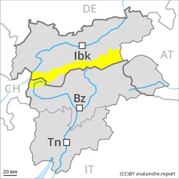
Danger level
2200m
Avalanche Problem
Wind slab
2200m
Gliding snow
2600m
The sometimes strong wind will transport the snow. Fresh wind slabs represent the main danger.
The new snow and wind slabs can be released by a single winter sport participant in particular on steep shady slopes above approximately 2200 m. As a consequence of the sometimes strong wind the wind slabs will increase in size additionally. Avalanches can reach medium size. The prevalence of the avalanche prone locations will increase with altitude. Caution is to be exercised in particular adjacent to ridgelines and in gullies and bowls.
Avalanches can in very isolated cases be triggered in the old snowpack and reach quite a large size. Avalanche prone locations are to be found in particular on steep shady slopes above approximately 2400 m. Places where surface hoar has been covered with snow are especially unfavourable.
From origins in starting zones where no previous releases have taken place more gliding avalanches are possible, even large ones in isolated cases. This applies in particular below approximately 2600 m. Caution is to be exercised in areas with glide cracks.
Snowpack
dp.6: cold, loose snow and wind dp.8: surface hoar blanketed with snow
The wind will be moderate to strong over a wide area. The new snow and wind slabs are lying on soft layers in particular on wind-protected shady slopes above approximately 2200 m.
Faceted weak layers exist in the centre of the old snowpack in particular on west, north and east facing slopes. This applies above approximately 2400 m. The new snow and wind slabs are lying on surface hoar in some places in particular on shady slopes.
As a consequence of rising temperatures and solar radiation a crust formed on the surface, in particular on steep sunny slopes in all altitude zones.
Tendency
The fresh and older wind slabs remain prone to triggering in particular on shady slopes at elevated altitudes. More gliding avalanches are possible, in particular medium-sized ones.
Danger level
2200m
Avalanche Problem
Wind slab
2200m
Gliding snow
2600m
Slight increase in avalanche danger as a consequence of new snow and wind.
The new snow and wind slabs can be released by a single winter sport participant especially on steep shady slopes above approximately 2200 m. Caution is to be exercised in particular adjacent to ridgelines and in gullies and bowls. In the regions exposed to heavier precipitation the avalanche prone locations are more prevalent and larger. The prevalence of the avalanche prone locations will increase with altitude. The fresh and somewhat older wind slabs are covered with new snow in some cases and therefore difficult to recognise. Avalanches can reach medium size.
From origins in starting zones where no previous releases have taken place more gliding avalanches are possible at any time, even large ones in isolated cases. This applies in particular below approximately 2600 m. Caution is to be exercised in areas with glide cracks.
Snowpack
dp.6: cold, loose snow and wind dp.2: gliding snow
In some regions up to 10 cm of snow fell on Tuesday. Over a wide area 10 to 20 cm of snow will fall on Wednesday. Lechtal Alps, Silvretta, Tuxer Alps as well as Kitzbühel Alps: In some localities up to 30 cm of snow will fall.
The wind will be moderate to strong over a wide area. The fresh and older wind slabs are lying on unfavourable layers above approximately 2200 m. This applies in particular in gullies and bowls, and behind abrupt changes in the terrain, as well as on near-ridge shady slopes. Hardly any weak layers exist in the top section of the old snowpack.
Tendency
The wind slabs remain in some cases prone to triggering.
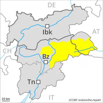
Danger level
2200m
Avalanche Problem
Wind slab
2200m
The sometimes strong wind will transport the snow. Fresh wind slabs represent the main danger.
The new snow and wind slabs can be released by a single winter sport participant in particular on steep shady slopes above approximately 2200 m. As a consequence of the sometimes strong wind the wind slabs will increase in size additionally. Avalanches can reach medium size. The prevalence of the avalanche prone locations will increase with altitude. Caution is to be exercised in particular adjacent to ridgelines and in gullies and bowls.
Hardly any more gliding avalanches are possible.
Snowpack
dp.6: cold, loose snow and wind
The wind will be moderate to strong over a wide area. The new snow and wind slabs are lying on soft layers in particular on wind-protected shady slopes above approximately 2200 m.
Faceted weak layers exist in the centre of the old snowpack in particular on west, north and east facing slopes. This applies above approximately 2400 m.
As a consequence of rising temperatures and solar radiation a crust formed on the surface, in particular on steep sunny slopes in all altitude zones.
Tendency
The fresh and older wind slabs remain prone to triggering in particular on shady slopes at elevated altitudes.