Fresh wind slabs represent the main danger. Loose snow avalanches require caution.
The new snow and wind slabs can be released by a single winter sport participant in particular on steep shady slopes above approximately 2400 m. The wind slabs are covered with new snow in some cases and therefore difficult to recognise. Avalanches can reach medium size. The prevalence of the avalanche prone locations will increase with altitude. Caution is to be exercised in particular adjacent to ridgelines and in gullies and bowls. As a consequence of warming during the day and solar radiation more frequent loose snow avalanches are to be expected, but they will be mostly small.
From origins in starting zones where no previous releases have taken place more gliding avalanches are possible, in particular medium-sized ones. This applies in particular on steep sunny slopes below approximately 2600 m, as well as on steep shady slopes below approximately 2200 m. Caution is to be exercised in areas with glide cracks.
Snowpack
dp.6: cold, loose snow and wind dp.2: gliding snow
In particular in the west 10 to 25 cm of snow, and even more in some localities, fell in the last few days. The new snow and wind slabs are lying on soft layers in particular on wind-protected shady slopes above approximately 2400 m.
Faceted weak layers exist in the centre of the old snowpack in particular on west, north and east facing slopes. This applies above approximately 2400 m. As a consequence of rising temperatures and solar radiation the snowpack will settle in the course of the day. Sunshine and high temperatures will give rise as the day progresses to increasing moistening of the snowpack, especially on sunny slopes, and on shady slopes at intermediate altitudes.
Tendency
As a consequence of mild temperatures and solar radiation the snow drift accumulations will stabilise. Gradual decrease in avalanche danger.
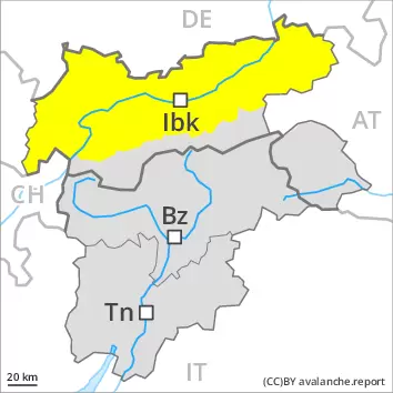
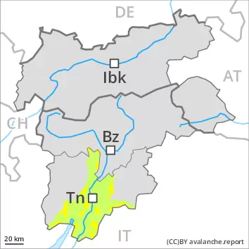
Danger level
2400m
Avalanche Problem
Wind slab
2400m
Gliding snow
2600m
Fresh wind slabs represent the main danger. Loose snow avalanches require caution.
The new snow and wind slabs can be released by a single winter sport participant in particular on steep shady slopes above approximately 2400 m. The wind slabs are covered with new snow in some cases and therefore difficult to recognise. Avalanches can reach medium size. The prevalence of the avalanche prone locations will increase with altitude. Caution is to be exercised in particular adjacent to ridgelines and in gullies and bowls. As a consequence of warming during the day and solar radiation more frequent loose snow avalanches are to be expected, but they will be mostly small.
Avalanches can in very isolated cases be triggered in the old snowpack and reach quite a large size. Avalanche prone locations are to be found in particular on steep shady slopes above approximately 2400 m.
From origins in starting zones where no previous releases have taken place more gliding avalanches are possible, in particular medium-sized ones. This applies in particular on steep sunny slopes below approximately 2600 m, as well as on steep shady slopes below approximately 2200 m. Caution is to be exercised in areas with glide cracks.
Snowpack
dp.6: cold, loose snow and wind dp.2: gliding snow
In particular in the west 10 to 25 cm of snow, and even more in some localities, fell in the last few days. The new snow and wind slabs are lying on soft layers in particular on wind-protected shady slopes above approximately 2400 m.
Faceted weak layers exist in the centre of the old snowpack in particular on west, north and east facing slopes. This applies above approximately 2400 m. As a consequence of rising temperatures and solar radiation the snowpack will settle in the course of the day. Sunshine and high temperatures will give rise as the day progresses to increasing moistening of the snowpack, especially on sunny slopes, and on shady slopes at intermediate altitudes.
Tendency
As a consequence of mild temperatures and solar radiation the snow drift accumulations will stabilise. Gradual decrease in avalanche danger.
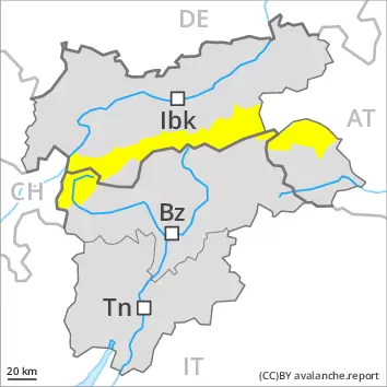
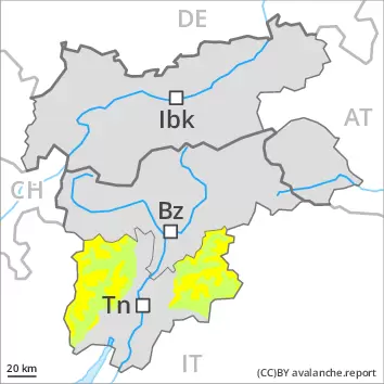
Danger level
2400m
Avalanche Problem
Persistent weak layer
2400m
Wind slab
2400m
Gliding snow
2600m
Wind slabs and weakly bonded old snow require caution.
Avalanches can be triggered in the old snowpack and reach large size in isolated cases. Avalanche prone locations are to be found in particular on steep, little used shady slopes above approximately 2400 m. Individual avalanche prone locations are to be found also on steep southeast, south and southwest facing slopes above approximately 2600 m. These avalanche prone locations are rather rare and are difficult to recognise. Released avalanches and reports filed by observers confirm the unfavourable bonding of the snowpack. In addition as the day progresses in particular in the regions exposed to heavier precipitation, an increasing number of loose snow avalanches are possible.
The fresh and somewhat older wind slabs can be released easily by a single winter sport participant in particular on steep shady slopes above approximately 2400 m. Caution is to be exercised in particular adjacent to ridgelines and in gullies and bowls. The prevalence of the avalanche prone locations will increase with altitude. Avalanches can reach medium size.
From origins in starting zones where no previous releases have taken place more gliding avalanches are possible, even large ones in isolated cases. This applies in particular below approximately 2600 m. Caution is to be exercised in areas with glide cracks.
Snowpack
dp.6: cold, loose snow and wind dp.2: gliding snow
The fresh and somewhat older wind slabs are lying on soft layers on wind-protected shady slopes above approximately 2400 m.
Faceted weak layers exist in the centre of the old snowpack in particular on west, north and east facing slopes. This applies above approximately 2400 m.
As a consequence of rising temperatures and solar radiation a crust formed on the surface, in particular on steep sunny slopes in all altitude zones. Sunshine and high temperatures will give rise as the day progresses to increasing moistening of the snowpack, especially on sunny slopes, and on shady slopes at intermediate altitudes.
Tendency
As a consequence of mild temperatures and solar radiation the snow drift accumulations will stabilise. Gradual decrease in avalanche danger.
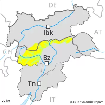
Danger level
2400m
Avalanche Problem
Wind slab
2400m
Gliding snow
2600m
Wind slabs represent the main danger, in particular on shady slopes above approximately 2400 m.
The wind slabs of the last few days can be released in particular on steep shady slopes above approximately 2400 m. Avalanches can reach medium size. The prevalence of the avalanche prone locations will increase with altitude. Caution is to be exercised in particular adjacent to ridgelines and in gullies and bowls.
Avalanches can in very isolated cases be triggered in the old snowpack and reach quite a large size. Avalanche prone locations are to be found in particular on steep shady slopes above approximately 2400 m.
From origins in starting zones where no previous releases have taken place more gliding avalanches are possible, in particular medium-sized ones. This applies in particular on steep sunny slopes below approximately 2600 m, as well as on steep shady slopes below approximately 2200 m. Caution is to be exercised in areas with glide cracks.
Snowpack
dp.6: cold, loose snow and wind dp.2: gliding snow
The fresh and somewhat older wind slabs are lying on soft layers on wind-protected shady slopes above approximately 2400 m.
Faceted weak layers exist in the centre of the old snowpack in particular on west, north and east facing slopes. This applies above approximately 2400 m.
As a consequence of rising temperatures and solar radiation a crust formed on the surface, in particular on steep sunny slopes in all altitude zones. Sunshine and high temperatures will give rise as the day progresses to increasing moistening of the snowpack, especially on sunny slopes, and on shady slopes at intermediate altitudes.
Tendency
As a consequence of mild temperatures and solar radiation the snow drift accumulations will stabilise. Gradual decrease in avalanche danger.
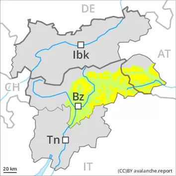
Danger level
treeline
Avalanche Problem
Wet snow
Treeline
Wind slab
2200m
The danger of moist avalanches will increase during the day. The fresh and older wind slabs must be evaluated with care and prudence.
As a consequence of warming moist and wet avalanches are possible as the day progresses, but they can reach medium size in some cases, in particular on steep sunny slopes below approximately 2400 m. Areas with glide cracks are to be avoided. The new snow and wind slabs of the weekend are to be evaluated with care and prudence in all aspects at high altitudes and in high Alpine regions. Avalanches can be triggered in near-surface layers and reach medium size in all aspects. Caution is to be exercised in particular adjacent to ridgelines and in gullies and bowls, as well as in places that are protected from the wind.
Snowpack
dp.10: springtime scenario dp.6: cold, loose snow and wind
Outgoing longwave radiation during the night will be quite good. The solar radiation will give rise as the day progresses to gradual moistening of the snowpack in particular on steep sunny slopes at intermediate altitudes. In all regions below the tree line a little snow is lying.
Tendency
The weather conditions will facilitate a gradual strengthening of the snowpack.
Danger level
treeline
Avalanche Problem
Wind slab
Treeline
Wet snow
2600m
Treeline
The fresh and older wind slabs must be evaluated with care and prudence in all aspects. The danger of moist snow slides and avalanches will increase during the day.
Below approximately 2600 m small and, in isolated cases, medium-sized moist and wet avalanches are possible. As the day progresses as a consequence of warming during the day and solar radiation there will be a gradual increase in the danger of moist and wet avalanches, in particular on steep sunny slopes above the tree line, as well as on steep east, south and west facing slopes. Caution is to be exercised in areas with glide cracks. In the regions with a lot of snow dry slab avalanches are possible. The new snow and wind slabs of the last few days can be released, especially by large additional loads, in all aspects at high altitudes and in high Alpine regions. These can in isolated cases reach quite a large size. The prevalence of the avalanche prone locations will increase with altitude. Caution is to be exercised in particular adjacent to ridgelines and in gullies and bowls, as well as in places that are protected from the wind.
Snowpack
dp.10: springtime scenario
Outgoing longwave radiation during the night will be quite good. The solar radiation will give rise as the day progresses to gradual moistening of the snowpack in particular on steep sunny slopes at intermediate altitudes. As a consequence of the occasionally strong wind, the snow drift accumulations have increased in size during the last few days. The new snow and wind slabs of the last few days are lying on soft layers above approximately 2200 m. The weather conditions gave rise to gradual settling of the snowpack. In all regions below the tree line a little snow is lying.
Tendency
Gradual decrease in danger of dry avalanches as a consequence of warming during the day. More gliding avalanches and wet snow slides are possible on Friday, in particular medium-sized ones.