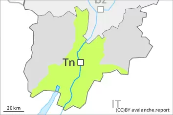
Danger level
 | 2600m |
|  |
|  | ||||
|  |
|  |


![]()
Wet and gliding snow require caution. Wind slabs are in individual cases still prone to triggering.
The fresh and older wind slabs can be released by a single winter sport participant in isolated cases in particular on very steep shady slopes above approximately 2600 m. Avalanches can in very isolated cases reach medium size. The prevalence of the avalanche prone locations will increase with altitude. Especially slopes adjacent to ridgelines are unfavourable.
Avalanches can in very isolated cases be triggered in the old snowpack and reach quite a large size. Avalanche prone locations are to be found in particular on steep shady slopes above approximately 2600 m.
As a consequence of warming during the day and solar radiation more wet loose snow avalanches are to be expected as the day progresses. From origins in starting zones where no previous releases have taken place more gliding avalanches are possible, even medium-sized ones. This applies in particular on steep sunny slopes below approximately 2600 m. Caution is to be exercised in areas with glide cracks.
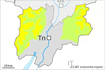
Snowpack
dp.6: cold, loose snow and wind
dp.10: springtime scenario
In some regions 2 to 5 cm of snow, and even more in some localities, fell yesterday above approximately 2200 m. As a consequence of the northwesterly wind, fresh snow drift accumulations formed. The fresh wind slabs are mostly small. Fresh and somewhat older wind slabs are lying on soft layers on wind-protected shady slopes above approximately 2600 m. The new snow is lying on a crust on steep sunny slopes.
Outgoing longwave radiation during the night will be quite good over a wide area. The snowpack is moist and its surface has a melt-freeze crust that is strong in many cases. The spring-like weather conditions as the day progresses will give rise to increasing moistening of the snowpack below approximately 2600 m. This applies especially on steep sunny slopes at elevated altitudes.
Isolated avalanche prone weak layers exist in the centre of the snowpack in particular on west, north and east facing slopes. At low altitude only a little snow is lying.
Tendency
On Tuesday it will be mild. The weather conditions will foster a substantial stabilisation of the snow drift accumulations.
Sunshine and high temperatures will give rise as the day progresses to softening of the snowpack especially on steep sunny slopes.