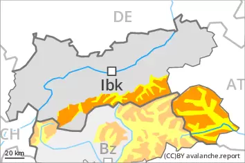
A precarious avalanche situation will prevail. Significant increase in avalanche danger as a consequence of the precipitation.
As a consequence of new snow and a strong wind, further wind slabs will form from the middle of the day in all aspects. These can be released easily or naturally. Caution is to be exercised in particular in gullies and bowls, and behind abrupt changes in the terrain above the tree line, and in areas close to the tree line. The prevalence of avalanche prone locations and likelihood of triggering will increase with altitude. In some cases avalanches are large.
On steep grassy slopes medium-sized and, in isolated cases, large gliding avalanches are possible. This applies especially on steep sunny slopes below approximately 2600 m, including on steep shady slopes below approximately 2200 m. Areas with glide cracks are to be avoided.
As a consequence of the heavy rain more frequent moist loose snow avalanches are to be expected from midday, even medium-sized ones. This applies in particular on extremely steep slopes in all aspects below the tree line.
Backcountry touring calls for very extensive experience and restraint.
Snowpack
dp.6: cold, loose snow and wind dp.2: gliding snow
30 to 40 cm of snow, and even more in some localities, will fall from midday. This applies in particular above the tree line. Fresh and somewhat older wind slabs are lying on soft layers in all aspects at elevated altitudes. The rain will give rise to a loss of strength within the snowpack.
Tendency
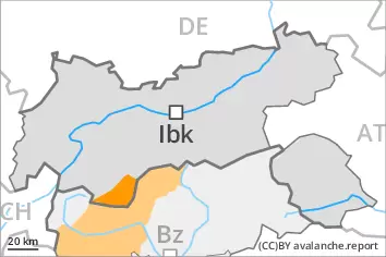
A critical avalanche situation will be encountered over a wide area. 10 to 15 cm of snow, and even more in some localities, will fall. As a consequence of new snow and strong wind there will be an increase in the avalanche danger within the current danger level. High altitudes and the high Alpine regions: New snow and wind slabs represent the main danger. Below approximately 2600 m: Wet and gliding snow require caution.
AM Danger level
2400m
Avalanche Problem
Wind slab
2400m
Gliding snow
2600m
PM Danger level
2200m
Avalanche Problem
Wind slab
2200m
Gliding snow
2600m
Increase in avalanche danger as a consequence of the precipitation.
As a consequence of new snow and a strong wind, further wind slabs will form from the middle of the day in particular on west, north and east facing slopes. These can be released easily. Caution is to be exercised in particular in gullies and bowls, and behind abrupt changes in the terrain above approximately 2200 m. The prevalence of avalanche prone locations and likelihood of triggering will increase with altitude. Mostly avalanches are medium-sized.
On steep grassy slopes medium-sized and, in isolated cases, large gliding avalanches are possible. This applies especially on steep sunny slopes below approximately 2600 m, including on steep shady slopes below approximately 2200 m. Areas with glide cracks are to be avoided.
As a consequence of the rain individual moist loose snow slides are to be expected from midday. This applies in particular on extremely steep slopes in all aspects below the tree line.
Backcountry touring calls for experience and restraint.
Snowpack
dp.6: cold, loose snow and wind dp.2: gliding snow
10 to 20 cm of snow, and even more in some localities, will fall from midday. This applies in particular above the tree line. Fresh and somewhat older wind slabs are lying on soft layers in particular on west to north to east facing aspects at elevated altitudes. The rain will give rise to a loss of strength within the snowpack.
Tendency
Up to 10 cm of snow, and even more in some localities, will fall. High altitudes and the high Alpine regions: Wind slabs represent the main danger. Below approximately 2600 m: Wet and gliding snow require caution.
Danger level
Avalanche Problem
Gliding snow
Wet and gliding snow are to be assessed with care and prudence.
As the day progresses more frequent wet and gliding avalanches are to be expected. This applies especially on steep sunny slopes in all altitude zones, and on steep shady slopes below approximately 2200 m. Avalanches can reach medium size. Areas with glide cracks are to be avoided.
Over a wide area stormy weather to low altitudes. The fresh wind slabs but can only be released in isolated cases. Such avalanche prone locations are to be found on very steep shady slopes above approximately 2400 m. Restraint should be exercised because avalanches can sweep people along and give rise to falls.
Snowpack
dp.2: gliding snow dp.10: springtime scenario
The high temperatures as the day progresses will give rise to rapid softening of the snowpack.
The wind will be violent in the vicinity of peaks. Fresh wind slabs are lying on soft layers on shady slopes at elevated altitudes.
Tendency
The weather conditions will give rise to softening of the snowpack.
Danger level
2400m
Avalanche Problem
Wind slab
2400m
Gliding snow
2600m
Fresh wind slabs are to be evaluated with care and prudence. Wet and gliding snow require caution.
As a consequence of a sometimes violent wind, further wind slabs will form. These can be released even by a single winter sport participant in particular on very steep shady slopes. Caution is to be exercised in particular in gullies and bowls, and behind abrupt changes in the terrain above approximately 2400 m. The prevalence of avalanche prone locations and likelihood of triggering will increase with altitude.
As a consequence of warming during the day more frequent wet and gliding avalanches are to be expected. This applies especially on steep sunny slopes below approximately 2600 m, including on steep shady slopes below approximately 2200 m. Areas with glide cracks are to be avoided.
Snowpack
dp.6: cold, loose snow and wind dp.10: springtime scenario
The wind will be violent at times in particular in the regions exposed to the foehn wind. Fresh and somewhat older wind slabs are lying on soft layers in particular on shady slopes at elevated altitudes.
The high temperatures as the day progresses will give rise to rapid softening of the snowpack.
Tendency
The weather conditions will give rise to softening of the snowpack. Wet and gliding snow represent the main danger. Fresh wind slabs require caution.