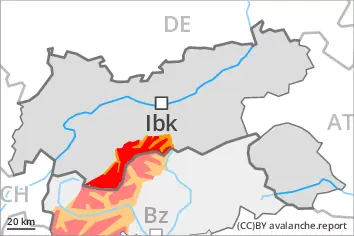
As a consequence of the heavy precipitation a large number of natural avalanches are to be expected, even large ones.
A sometimes critical avalanche situation will prevail.
The large quantity of fresh snow as well as the large wind slabs that are being formed by the storm force to violent southerly wind can be released easily or naturally in all aspects above the tree line. Large avalanches are to be expected. At intermediate altitudes these can release the wet old snow as well. The prevalence of avalanche prone locations and likelihood of triggering will increase with altitude. The peak of avalanche activity will be reached by the early morning probably. Evening: As the wind changes direction, the likelihood of natural dry avalanches being released will increase a little in particular at elevated altitudes.
On steep grassy slopes medium-sized to large gliding avalanches are possible. This applies especially on steep sunny slopes below approximately 2600 m, including on steep shady slopes below approximately 2200 m. Areas with glide cracks are to be avoided.
As a consequence of the rain moist and wet avalanches are to be expected at any time, even medium-sized ones. This applies in particular on very steep slopes in all aspects below the tree line.
Snowpack
dp.6: cold, loose snow and wind dp.2: gliding snow
30 to 40 cm of snow, and even more in some localities, will fall. A lot of snow fell in the last few days over a wide area. This applies in particular above the tree line. Fresh and somewhat older wind slabs are lying on soft layers in all aspects at elevated altitudes. The rain will give rise to a loss of strength within the snowpack.
Tendency
Slight decrease in danger of dry avalanches. High altitudes and the high Alpine regions: New snow and wind slabs represent the main danger. Below approximately 2600 m: Wet and gliding snow require caution. As a consequence of warming during the day and solar radiation a large number of wet loose snow avalanches are to be expected as the day progresses, even quite large ones.
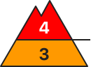
Danger level
treeline
Avalanche Problem
Wind slab
Treeline
Gliding snow
2600m
Wet snow
Treeline
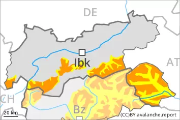
A precarious avalanche situation will prevail.
The fresh snow as well as the wind slabs that are being formed by the storm force to violent southerly wind can be released easily or naturally in all aspects above the tree line. Occasionally large avalanches are possible. At intermediate altitudes these can release the wet old snow as well. The prevalence of avalanche prone locations and likelihood of triggering will increase with altitude. The peak of avalanche activity will be reached by the early morning probably. Evening: As the wind changes direction, the likelihood of natural dry avalanches being released will increase a little in particular at elevated altitudes.
On steep grassy slopes medium-sized and, in isolated cases, large gliding avalanches are possible. This applies especially on steep sunny slopes below approximately 2600 m, including on steep shady slopes below approximately 2200 m. Areas with glide cracks are to be avoided.
As a consequence of the rain moist and wet avalanches are possible, even medium-sized ones. This applies in particular on very steep slopes in all aspects below the tree line.
Snowpack
dp.6: cold, loose snow and wind dp.2: gliding snow
15 to 30 cm of snow, and even more in some localities, will fall. This applies in particular above the tree line. Fresh and somewhat older wind slabs are lying on soft layers in all aspects at elevated altitudes. The rain will give rise to a loss of strength within the snowpack.
Tendency
Slight decrease in danger of dry avalanches. High altitudes and the high Alpine regions: Fresh wind slabs represent the main danger. Below approximately 2600 m: Wet and gliding snow require caution. As a consequence of warming during the day and solar radiation a large number of wet loose snow avalanches are to be expected as the day progresses, in particular medium-sized ones.
Danger level
Avalanche Problem
Gliding snow
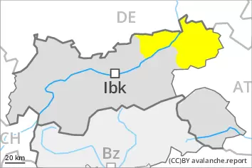
Wet and gliding snow are to be assessed with care and prudence.
As the day progresses more frequent wet and gliding avalanches are to be expected. This applies especially on steep sunny slopes in all altitude zones, and on steep shady slopes below approximately 2200 m. Avalanches can reach medium size. Areas with glide cracks are to be avoided.
Over a wide area stormy weather to low altitudes. The fresh wind slabs but can only be released in isolated cases. Such avalanche prone locations are to be found on very steep shady slopes above approximately 2200 m. Restraint should be exercised because avalanches can sweep people along and give rise to falls.
Snowpack
dp.2: gliding snow dp.10: springtime scenario
The rain will give rise as the day progresses to softening of the snowpack.
The wind will be storm force over a wide area. Fresh wind slabs are lying on soft layers on shady slopes at elevated altitudes.
Tendency
Slight decrease in danger of dry avalanches. Fresh wind slabs require caution. Wet and gliding snow require caution. As a consequence of warming during the day and solar radiation wet loose snow avalanches are possible as the day progresses, but they will be mostly small.
Danger level
2200m
Avalanche Problem
Wind slab
2200m
Gliding snow
2600m
Wet snow
2200m
Fresh wind slabs represent the main danger. Wet and gliding snow require caution.
As a consequence of a sometimes violent wind, further wind slabs will form. These can be released easily, even by a single winter sport participant, in particular on northwest to north to east facing aspects. Caution is to be exercised in particular in gullies and bowls, and behind abrupt changes in the terrain above approximately 2200 m. The prevalence of avalanche prone locations and likelihood of triggering will increase with altitude.
On steep grassy slopes medium-sized and, in isolated cases, large gliding avalanches are possible. This applies especially on steep sunny slopes below approximately 2600 m, including on steep shady slopes below approximately 2200 m. Areas with glide cracks are to be avoided.
As a consequence of the rain moist and wet avalanches are possible, even medium-sized ones. This applies in particular on very steep slopes in all aspects below approximately 2200 m.
Snowpack
dp.6: cold, loose snow and wind dp.10: springtime scenario
The wind will be storm force over a wide area. Fresh and somewhat older wind slabs are lying on soft layers in particular on northwest to north to east facing aspects at elevated altitudes.
The rain will give rise to softening of the snowpack.
Tendency
Slight decrease in danger of dry avalanches. High altitudes and the high Alpine regions: Fresh wind slabs require caution. Below approximately 2600 m: Wet and gliding snow require caution. As a consequence of warming during the day and solar radiation wet loose snow avalanches are to be expected as the day progresses, but they will be mostly small.