Danger level
 |
|  |  | |||||
|  |
| |


![]()
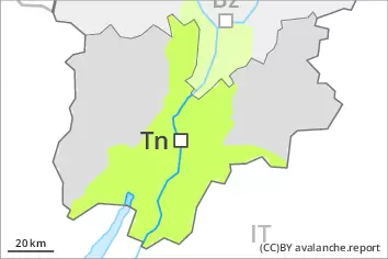
A dangerous avalanche situation will be encountered over a wide area.
The danger of wet avalanches will already exist in the early morning. As a consequence of warming during the day and the solar radiation, the likelihood of wet avalanches being released will increase appreciably. This applies on steep sunny slopes in all altitude zones, as well as on steep, rather lightly snow-covered shady slopes below approximately 2600 m. The danger of wet avalanches during the day is within the upper range of danger level 3 (considerable).
On steep grassy slopes more medium-sized and, in isolated cases, large gliding avalanches are possible below approximately 2600 m. Areas with glide cracks are to be avoided.
In isolated cases wet avalanches can release the saturated snowpack and reach large size. In steep gullies avalanches can in isolated cases reach valley bottoms at relatively high altitudes. Backcountry tours and ascents to alpine cabins should be started and concluded very early.
Snowpack
dp.10: springtime scenario
dp.2: gliding snow
The snowpack will be wet all the way through. This applies on sunny slopes in all altitude zones, as well as on shady slopes below approximately 2500 m. The weather will be very warm. Up to 3000 m rain will fall in some localities.
The surface of the snowpack will cool hardly at all during the overcast night and will already be soft in the early morning. The weather conditions as the day progresses will give rise to increasing and thorough wetting of the snowpack. This situation will give rise to a loss of strength within the snowpack, especially on steep shady slopes.
Tendency
Decrease in danger of wet avalanches as the temperature drops.