Individual avalanche prone locations for dry avalanches are to be found on shady slopes at elevated altitudes. Increase in danger of wet avalanches in the course of the day.
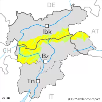
Early and late morning: Fresh wind slabs are in isolated cases prone to triggering on very steep shady slopes in high Alpine regions. The avalanche prone locations are clearly recognisable to the trained eye. Avalanches can additionally in very isolated cases be released in the old snowpack. These avalanche prone locations are to be found on extremely steep shady slopes above approximately 2600 m. Dry avalanches can reach medium size in isolated cases. Apart from the danger of being buried, restraint should be exercised in particular in view of the danger of avalanches sweeping people along and giving rise to falls.
During the day: As a consequence of warming during the day and the solar radiation, the likelihood of wet avalanches being released will increase gradually especially on extremely steep sunny slopes. Especially on extremely steep sunny slopes small to medium-sized wet loose snow avalanches are possible. This also applies in isolated cases on shady slopes below approximately 2600 m.
In addition further gliding avalanches are possible. This applies on steep grassy slopes below approximately 2600 m. Areas with glide cracks are to be avoided.
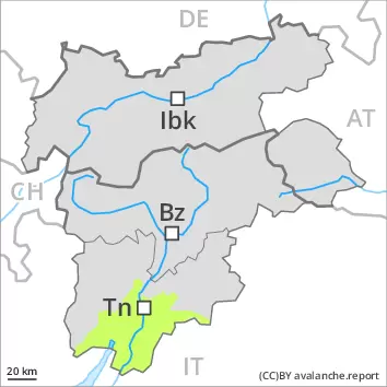
Snowpack
dp.10: springtime scenario dp.6: cold, loose snow and wind
The surface of the snowpack has frozen to form a strong crust and will soften during the day. This applies in particular on sunny slopes. The high temperatures as the day progresses will give rise to increasing softening of the snowpack also on shady slopes below approximately 2600 m.
Isolated avalanche prone weak layers exist in the top section of the snowpack on shady slopes. As a consequence of a strong wind from southerly directions, wind slabs formed in high Alpine regions. The weather effects will bring about a rapid stabilisation of the snow drift accumulations.
Tendency
The backcountry touring conditions in the morning are favourable over a wide area. The danger of wet avalanches will increase during the day.
EARLIER Danger level
2400m
Avalanche Problem
Persistent weak layer
2400m
Wet snow
LATER Danger level
3000m
Avalanche Problem
Wet snow
3000m
Persistent weak layer
2400m
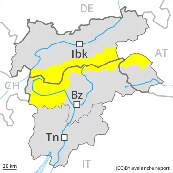
A clear night will be followed by favourable conditions over a wide area. Increase in danger of wet and gliding avalanches in the course of the day.
Especially on rocky sunny slopes small to medium-sized wet loose snow avalanches are to be expected. As the day progresses also on shady slopes there will be an increase in the danger of wet avalanches. In addition individual small and medium-sized gliding avalanches are possible. This applies on steep grassy slopes below approximately 2600 m. Areas with glide cracks are to be avoided.
Weak layers in the upper part of the snowpack can still be released in isolated cases by winter sport participants on very steep shady slopes. Shady slopes are unfavourable, in particular above approximately 2400 m. Mostly avalanches are medium-sized. The avalanche prone locations are difficult to recognise. In addition the fresh wind slabs in high Alpine regions are prone to triggering in some cases.
Snowpack
dp.10: springtime scenario
The surface of the snowpack will freeze to form a strong crust only at high altitudes. The high temperatures as the day progresses will give rise to increasing softening of the snowpack also on shady slopes at elevated altitudes. Caution is to be exercised in particular on sunny slopes below approximately 3000 m. Isolated avalanche prone weak layers exist in the top section of the snowpack especially on shady slopes. As a consequence of a sometimes strong southwesterly wind, sometimes avalanche prone wind slabs formed in the vicinity of peaks. This applies in particular at high altitude.
Tendency
The danger of wet avalanches will persist.
EARLIER Danger level
LATER Danger level
Avalanche Problem
Wet snow
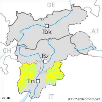
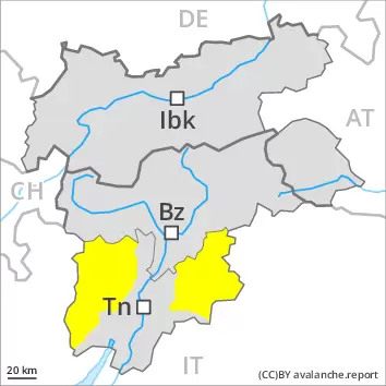
Increase in danger of wet and gliding avalanches in the course of the day.
On extremely steep slopes small to medium-sized wet loose snow avalanches are possible as a consequence of warming during the day and solar radiation. In addition further small and, in isolated cases, medium-sized gliding avalanches are possible. This applies on steep grassy slopes. Areas with glide cracks are to be avoided.
Snowpack
dp.10: springtime scenario dp.2: gliding snow
The surface of the snowpack will freeze to form a strong crust and will soften during the day. The old snowpack will be stable.
Tendency
Wet loose snow avalanches and gliding avalanches are still possible.
EARLIER Danger level
LATER Danger level
2800m
Avalanche Problem
Wet snow
2800m
A clear night will be followed by favourable conditions over a wide area, but the danger of wet avalanches will increase later.
Early and late morning: Weak layers in the upper part of the snowpack can still be released in very isolated cases. These avalanche prone locations are to be found on extremely steep shady slopes above approximately 2600 m. Mostly avalanches are small. Apart from the danger of being buried, restraint should be exercised in particular in view of the danger of avalanches sweeping people along and giving rise to falls.
During the day: As a consequence of warming during the day and the solar radiation, the likelihood of wet avalanches being released will increase gradually especially on extremely steep sunny slopes. Especially on extremely steep sunny slopes small to medium-sized wet loose snow avalanches are possible. This also applies in isolated cases on shady slopes below approximately 2600 m.
In addition further gliding avalanches are possible. This applies on steep grassy slopes below approximately 2600 m. Areas with glide cracks are to be avoided.
Snowpack
dp.10: springtime scenario dp.2: gliding snow
The surface of the snowpack has frozen to form a strong crust and will soften during the day. This applies in particular on sunny slopes. The high temperatures as the day progresses will give rise to increasing softening of the snowpack also on shady slopes below approximately 2600 m.
Isolated avalanche prone weak layers exist in the top section of the snowpack on shady slopes. As a consequence of a strong wind from southerly directions, small wind slabs formed in the vicinity of peaks, especially in high Alpine regions. The weather effects will bring about a rapid stabilisation of the snow drift accumulations.
Tendency
The backcountry touring conditions in the morning are favourable over a wide area. The danger of wet avalanches will increase during the day.
EARLIER Danger level
LATER Danger level
2800m
Avalanche Problem
Wet snow
2800m
A clear night will be followed by favourable conditions over a wide area, but the danger of wet avalanches will increase later.
Early and late morning: Weak layers in the upper part of the snowpack can still be released in very isolated cases. These avalanche prone locations are to be found on extremely steep shady slopes above approximately 2600 m. Mostly avalanches are small. Apart from the danger of being buried, restraint should be exercised in particular in view of the danger of avalanches sweeping people along and giving rise to falls.
During the day: As a consequence of warming during the day and the solar radiation, the likelihood of wet avalanches being released will increase gradually especially on extremely steep sunny slopes. Especially on extremely steep sunny slopes small to medium-sized wet loose snow avalanches are possible. This also applies in isolated cases on shady slopes below approximately 2600 m.
In addition further gliding avalanches are possible. This applies on steep grassy slopes below approximately 2600 m. Areas with glide cracks are to be avoided.
Snowpack
dp.10: springtime scenario dp.2: gliding snow
The surface of the snowpack has frozen to form a strong crust and will soften during the day. This applies in particular on sunny slopes. The high temperatures as the day progresses will give rise to increasing softening of the snowpack also on shady slopes below approximately 2600 m.
Isolated avalanche prone weak layers exist in the top section of the snowpack on shady slopes. As a consequence of a strong wind from southerly directions, mostly small wind slabs formed at elevated altitudes.
Tendency
The backcountry touring conditions in the morning are favourable over a wide area. The danger of wet avalanches will increase during the day.
EARLIER Danger level
Avalanche Problem
Wet snow
LATER Danger level
2000m
Avalanche Problem
Wet snow
2000m
Wet snow requires caution.
The danger of wet avalanches will already increase in the early morning. Especially on rocky east, south and west facing slopes mostly small wet avalanches are to be expected. As the day progresses also on shady slopes there will be an increase in the danger of wet avalanches. In addition very occasional mostly small gliding avalanches are possible. This applies on steep grassy slopes. Areas with glide cracks are to be avoided.
Snowpack
dp.10: springtime scenario
The surface of the snowpack cooled hardly at all during the overcast night and will soften quickly, especially on sunny slopes below approximately 2800 m. The high temperatures as the day progresses will give rise to increasing softening of the snowpack also on shady slopes at elevated altitudes.
At low and intermediate altitudes hardly any snow is lying.
Tendency
The danger of wet avalanches will persist.
Danger level
Avalanche Problem
Wet snow
Wet snow requires caution.
The danger of wet avalanches will increase during the day. Especially on rocky slopes mostly small wet avalanches are to be expected. In addition very occasional mostly small gliding avalanches are possible. This applies on steep grassy slopes. Areas with glide cracks are to be avoided.
Snowpack
dp.10: springtime scenario
The surface of the snowpack has frozen to form a strong crust and will soften quickly. Sunshine and high temperatures will give rise as the day progresses to increasing softening of the snowpack also on shady slopes at elevated altitudes.
At low and intermediate altitudes hardly any snow is lying.