The sometimes new snow-covered wind slabs represent the main danger. Avalanches can be released in the weakly bonded old snow.
As a consequence of new snow and a moderate wind from easterly directions, further wind slabs will form on Sunday in some cases. In the last two days sometimes easily released wind slabs formed at high altitudes and in high Alpine regions. These avalanche prone locations are sometimes covered with new snow and are therefore difficult to recognise. They are to be found in particular on steep northwest, north and southeast facing slopes above approximately 2000 m. Caution is to be exercised in particular adjacent to ridgelines and in gullies and bowls. In high Alpine regions the avalanche prone locations are more prevalent and exist in all aspects. Avalanches are rather small but can be released even by a single winter sport participant.
Additionally in isolated cases avalanches can also be released in the old snowpack and reach medium size in isolated cases, in particular on very steep northwest, north and east facing slopes above approximately 2400 m. Caution is to be exercised in particular adjacent to ridgelines and in gullies and bowls.
In the regions exposed to heavier precipitation individual small gliding avalanches are possible.
Apart from the danger of being buried, restraint should be exercised as well in view of the danger of avalanches sweeping people along and giving rise to falls. The Avalanche Warning Service currently has only a small amount of information that has been collected in the field, so that the avalanche danger should be investigated especially thoroughly in the relevant locality.
Snowpack
dp.6: cold, loose snow and wind dp.1: deep persistent weak layer
Over a wide area 15 to 30 cm of snow will fall. In some places new snow is lying on a weakly bonded old snowpack, especially on northwest, north and east facing slopes at high altitudes and in high Alpine regions. Friday: The sometimes storm force wind has transported a lot of snow. In all altitude zones only a little snow is lying. The snowpack will be subject to considerable local variations. Snow depths vary greatly, depending on the infuence of the wind.
Tendency
Wind slabs are to be evaluated with care and prudence. Caution is to be exercised in particular adjacent to ridgelines and in gullies and bowls.
Danger level
2000m
Avalanche Problem
Wind slab
2000m
The sometimes new snow-covered wind slabs represent the main danger.
In the last two days sometimes easily released wind slabs formed at high altitudes and in high Alpine regions. These avalanche prone locations are covered with new snow and are therefore difficult to recognise. They are to be found in particular on steep northwest, north and southeast facing slopes above approximately 2000 m. Caution is to be exercised in particular adjacent to ridgelines and in gullies and bowls. At elevated altitudes the avalanche prone locations are more prevalent. Avalanches are rather small but can be released even by a single winter sport participant.
Apart from the danger of being buried, restraint should be exercised as well in view of the danger of avalanches sweeping people along and giving rise to falls. The Avalanche Warning Service currently has only a small amount of information that has been collected in the field, so that the avalanche danger should be investigated especially thoroughly in the relevant locality.
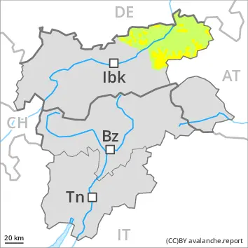
Snowpack
dp.6: cold, loose snow and wind
Over a wide area 10 to 20 cm of snow will fall. In some places new snow is lying on soft layers, especially on northwest, north and east facing slopes at elevated altitudes. Friday: The sometimes storm force wind has transported a lot of snow. In all altitude zones only a little snow is lying. The snowpack will be subject to considerable local variations. Snow depths vary greatly, depending on the infuence of the wind.
Tendency
Wind slabs are to be evaluated with care and prudence. Caution is to be exercised in particular adjacent to ridgelines and in gullies and bowls.
Danger level
2000m
Avalanche Problem
Wind slab
2000m
Persistent weak layer
2400m
The sometimes new snow-covered wind slabs represent the main danger. Avalanches can be released in the weakly bonded old snow.
In the last two days sometimes easily released wind slabs formed at high altitudes and in high Alpine regions. These avalanche prone locations are covered with new snow and are therefore difficult to recognise. They are to be found in particular on steep northwest, north and southeast facing slopes above approximately 2000 m. Caution is to be exercised in particular adjacent to ridgelines and in gullies and bowls. In high Alpine regions the avalanche prone locations are more prevalent and exist in all aspects. Avalanches are rather small but can be released even by a single winter sport participant.
Additionally in isolated cases avalanches can also be released in the old snowpack and reach medium size in isolated cases, in particular on very steep northwest, north and east facing slopes above approximately 2400 m. Caution is to be exercised in particular adjacent to ridgelines and in gullies and bowls.
Apart from the danger of being buried, restraint should be exercised as well in view of the danger of avalanches sweeping people along and giving rise to falls. The Avalanche Warning Service currently has only a small amount of information that has been collected in the field, so that the avalanche danger should be investigated especially thoroughly in the relevant locality.
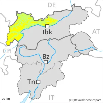
Snowpack
dp.6: cold, loose snow and wind dp.1: deep persistent weak layer
Over a wide area 10 to 20 cm of snow will fall. In some places new snow is lying on a weakly bonded old snowpack, especially on northwest, north and east facing slopes at high altitudes and in high Alpine regions. Friday: The sometimes storm force wind has transported a lot of snow. In all altitude zones only a little snow is lying. The snowpack will be subject to considerable local variations. Snow depths vary greatly, depending on the infuence of the wind.
Tendency
Wind slabs are to be evaluated with care and prudence. Caution is to be exercised in particular adjacent to ridgelines and in gullies and bowls.
Danger level
2000m
Avalanche Problem
Wind slab
2000m
Persistent weak layer
2400m
The sometimes new snow-covered wind slabs represent the main danger. Avalanches can be released in the weakly bonded old snow.
As a consequence of new snow and a moderate wind from easterly directions, further wind slabs will form on Sunday in some cases. In the last two days sometimes easily released wind slabs formed at high altitudes and in high Alpine regions. These avalanche prone locations are sometimes covered with new snow and are therefore difficult to recognise. They are to be found in particular on steep northwest, north and southeast facing slopes above approximately 2000 m. Caution is to be exercised in particular adjacent to ridgelines and in gullies and bowls. In high Alpine regions the avalanche prone locations are more prevalent and exist in all aspects. Avalanches are rather small but can be released even by a single winter sport participant.
Additionally in isolated cases avalanches can also be released in the old snowpack and reach medium size in isolated cases, in particular on very steep northwest, north and east facing slopes above approximately 2400 m. Caution is to be exercised in particular adjacent to ridgelines and in gullies and bowls.
In the regions exposed to heavier precipitation individual small gliding avalanches are possible.
Apart from the danger of being buried, restraint should be exercised as well in view of the danger of avalanches sweeping people along and giving rise to falls. The Avalanche Warning Service currently has only a small amount of information that has been collected in the field, so that the avalanche danger should be investigated especially thoroughly in the relevant locality.
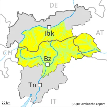
Snowpack
dp.6: cold, loose snow and wind dp.1: deep persistent weak layer
Over a wide area 15 to 30 cm of snow will fall. In some places new snow is lying on a weakly bonded old snowpack, especially on northwest, north and east facing slopes at high altitudes and in high Alpine regions. Friday: The sometimes storm force wind has transported a lot of snow. In all altitude zones only a little snow is lying. The snowpack will be subject to considerable local variations. Snow depths vary greatly, depending on the infuence of the wind.
Tendency
Wind slabs are to be evaluated with care and prudence. Caution is to be exercised in particular adjacent to ridgelines and in gullies and bowls.