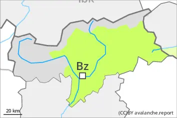
Danger level
 | treeline |
|  |
|  | ||||
| |
|  |


![]()
Increase in avalanche danger as a consequence of new snow and strong wind. Fresh wind slabs represent the main danger. Avalanches can be released in the weakly bonded old snow in isolated cases.
As a consequence of new snow and a sometimes strong wind from northerly directions, avalanche prone wind slabs will form in gullies and bowls and behind abrupt changes in the terrain. The avalanche prone locations are to be found in particular on north to northeast to east facing aspects above the tree line, but in isolated cases also in areas close to the tree line. Such avalanche prone locations are prevalent and are barely recognisable because of the poor visibility. Avalanches can reach medium size.
Additionally in isolated cases avalanches can be triggered in the old snowpack and reach large size in isolated cases, in particular on very steep northwest, north and east facing slopes above approximately 2400 m. Especially slopes adjacent to ridgelines are unfavourable. The number and size of avalanche prone locations will increase in the high Alpine regions.
Snowpack
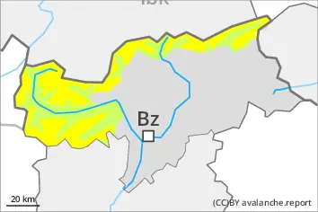
dp.6: cold, loose snow and wind
dp.1: deep persistent weak layer
Some snow will fall until the afternoon in particular along the border with Tirol. The wind will be strong in some cases. The wind will transport the fresh and old snow. The fresh wind slabs will be deposited on unfavourable layers.
Faceted weak layers exist in the centre of the old snowpack, especially on northwest, north and northeast facing slopes at high altitudes and in high Alpine regions.
In all altitude zones only a little snow is lying.
Tendency
The fresh wind slabs of the last few days remain prone to triggering. Additionally in some places avalanches can also penetrate near-ground layers of the snowpack and reach medium size.