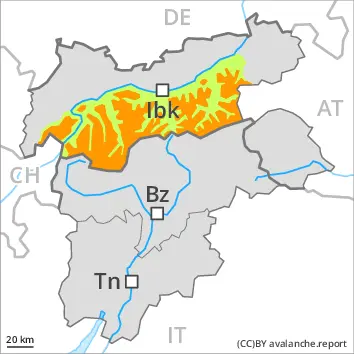
High avalanche danger will prevail. The off-piste conditions are dangerous.
The large quantity of fresh snow and the extensive wind slabs are very prone to triggering. Single winter sport participants can release avalanches in many places, including large ones. The avalanche prone locations are to be found in all aspects above the tree line. Individual avalanche prone locations are to be found also in areas close to the tree line. As a consequence of new snow and stormy weather the prevalence and size of these avalanche prone locations will increase in the afternoon. Already in the early morning, individual, then as the precipitation becomes heavier numerous natural avalanches are to be expected. They can in isolated cases penetrate near-ground layers of the snowpack. This applies in particular above approximately 2200 m.
Medium-sized gliding avalanches are possible on steep grassy slopes. They can be released at any time of day or night.
Snowpack
dp.6: cold, loose snow and wind dp.1: deep persistent weak layer
Over a wide area 30 to 60 cm of snow has fallen since Saturday. 10 to 20 cm of snow will fall until the evening. The wind will be strong to storm force adjacent to ridgelines. The various wind slabs have bonded poorly with each other and the old snowpack. Isolated avalanche prone weak layers exist in the bottom section of the old snowpack above approximately 2200 m.
Tendency
The avalanche danger will persist. As a consequence of new snow and stormy weather more large and, in isolated cases, very large natural avalanches are possible.
Danger level
treeline
Avalanche Problem
New snow
Treeline
Persistent weak layer
2200m
Gliding snow
2400m
The off-piste conditions are unfavourable.
The fresh snow and in particular the extensive wind slabs can be released very easily in all aspects above the tree line. Individual avalanche prone locations are to be found also in areas close to the tree line. Natural avalanches are possible as a consequence of the sometimes strong northwesterly wind. Mostly avalanches are medium-sized. They can in isolated cases penetrate near-ground layers of the snowpack and reach large size. This applies in particular above approximately 2200 m.
Small and medium-sized gliding avalanches are possible on steep grassy slopes. Gliding avalanches can be released at any time of day or night.
Snowpack
dp.6: cold, loose snow and wind dp.1: deep persistent weak layer
20 to 40 cm of snow has fallen since Saturday. In some regions up to 15 cm of snow will fall until the evening. The wind will be strong to storm force adjacent to ridgelines. The various wind slabs have bonded poorly with each other and the old snowpack. Faceted weak layers exist in the bottom section of the old snowpack above approximately 2200 m.
Tendency
Further increase in avalanche danger. As a consequence of new snow and stormy weather more frequent natural avalanches are to be expected.
Danger level
treeline
Avalanche Problem
Wind slab
Treeline
Persistent weak layer
2200m
As the day progresses as a consequence of new snow and wind there will be an increase in the avalanche danger. Fresh wind slabs represent the main danger. Weak layers in the lower part of the snowpack necessitate caution.
The fresh wind slabs will become increasingly prone to triggering. They can be released easily by a single winter sport participant in all aspects above the tree line. Individual, then as the day progresses more natural avalanches are to be expected. Avalanches are medium-sized. The avalanche prone locations are to be found in particular in gullies and bowls, and behind abrupt changes in the terrain. At elevated altitudes the avalanche prone locations will become more prevalent. Whumpfing sounds and the formation of shooting cracks when stepping on the snowpack can indicate the danger.
Avalanches can in some cases penetrate deep layers and reach large size in isolated cases. Caution is to be exercised in particular on very steep northwest, north and east facing slopes above approximately 2200 m.
As a consequence of the new snow more frequent loose snow avalanches are to be expected. On very steep grassy slopes individual gliding avalanches are possible, but they will be mostly small.
Snowpack
dp.6: cold, loose snow and wind dp.1: deep persistent weak layer
Up to 15 cm of snow, and even more in some localities, fell on Sunday. Over a wide area 10 to 20 cm of snow, and even more in some localities, will fall on Monday. As a consequence of a gathering storm force wind from northerly directions, easily released wind slabs will form in the course of the day over a wide area. The fresh snow as well as the wind slabs are lying on top of a weakly bonded old snowpack especially on west to north to southeast facing aspects. The snowpack will be subject to considerable local variations.
Tendency
Slight increase in avalanche danger as a consequence of new snow and wind. In some regions 10 to 20 cm of snow will fall on Tuesday. Fresh wind slabs represent the main danger. Weak layers in the old snowpack necessitate caution.
Danger level
treeline
Avalanche Problem
Wind slab
Treeline
Persistent weak layer
2200m
The off-piste conditions are unfavourable.
The extensive wind slabs can be released easily, even by a single winter sport participant, in all aspects above the tree line. Individual avalanche prone locations are to be found also in areas close to the tree line. The avalanche prone locations are to be found in particular in gullies and bowls, and behind abrupt changes in the terrain. They are numerous and are barely recognisable because of the poor visibility. Whumpfing sounds and the formation of shooting cracks when stepping on the snowpack can indicate the danger. Some medium-sized natural avalanches are possible as a consequence of the strong northwesterly wind. Avalanches can in some cases penetrate near-ground layers of the snowpack and reach large size.
On steep grassy slopes individual gliding avalanches are possible. Caution is to be exercised in areas with glide cracks.
Snowpack
dp.6: cold, loose snow and wind dp.1: deep persistent weak layer
15 to 30 cm of snow, and even more in some localities, fell on Sunday. Monday: Over a wide area 10 to 20 cm of snow will fall until the evening. As a consequence of a gathering storm force wind from northerly directions, further wind slabs will form from the middle of the day in all aspects. The new snow and wind slabs are lying on top of a weakly bonded old snowpack at high altitudes and in high Alpine regions. Released avalanches and field observations have confirmed poor snowpack stability especially above approximately 2200 m.
Tendency
Further increase in avalanche danger. Over a wide area 20 to 30 cm of snow, and even more in some localities, will fall on Monday. The wind will be strong. During the night the natural activity of avalanches will appreciably increase.
Danger level
treeline
Avalanche Problem
Wind slab
Treeline
Persistent weak layer
2200m
Increase in avalanche danger as a consequence of new snow and wind. Fresh wind slabs represent the main danger. Weak layers in the lower part of the snowpack necessitate caution.
The fresh wind slabs will become increasingly prone to triggering. They can be released easily by a single winter sport participant in all aspects above the tree line. Avalanches can also reach medium size. The avalanche prone locations are to be found in particular in gullies and bowls, and behind abrupt changes in the terrain. At elevated altitudes the avalanche danger is a little higher. Whumpfing sounds and the formation of shooting cracks when stepping on the snowpack can indicate the danger.
Avalanches can in some cases penetrate deep layers. Caution is to be exercised in particular on very steep northwest, north and east facing slopes above approximately 2200 m.
As a consequence of the new snow more frequent loose snow avalanches are to be expected. On very steep grassy slopes individual gliding avalanches are possible, but they will be mostly small.
Snowpack
dp.6: cold, loose snow and wind dp.1: deep persistent weak layer
In some regions up to 15 cm of snow fell on Sunday. Up to 15 cm of snow will fall on Monday. As a consequence of a gathering storm force wind from northerly directions, easily released wind slabs will form in the course of the day over a wide area. The fresh snow as well as the wind slabs are lying on top of a weakly bonded old snowpack especially on west to north to southeast facing aspects. The snowpack will be subject to considerable local variations.
Tendency
Fresh wind slabs represent the main danger. Weak layers in the old snowpack necessitate caution.
Danger level
treeline
Avalanche Problem
Wind slab
Treeline
Fresh wind slabs represent the main danger.
The various wind slabs of the last few days can be released by a single winter sport participant in some cases on northwest to north to southeast facing aspects. As a consequence of new snow and wind the wind slabs will increase in size additionally in the afternoon. The avalanche prone locations are to be found adjacent to ridgelines and in gullies and bowls above the tree line. Individual avalanche prone locations are to be found also in areas close to the tree line. The avalanche prone locations are barely recognisable because of the poor visibility. Avalanches can reach medium size.
Isolated small to medium-sized gliding avalanches are possible on steep grassy slopes.
Snowpack
dp.6: cold, loose snow and wind dp.2: gliding snow
10 to 15 cm of snow, and even more in some localities, fell on Sunday. Monday: Over a wide area 10 to 15 cm of snow will fall until the evening. The wind will be strong in some cases.
As a consequence of new snow and wind the wind slabs will increase in size additionally. These are lying on the unfavourable surface of an old snowpack in particular on steep north and east facing slopes above the tree line. Isolated avalanche prone weak layers exist in the bottom section of the old snowpack on shady slopes.
Tendency
Increase in avalanche danger. Over a wide area 15 to 30 cm of snow will fall on Monday. The wind will be strong in some cases.
Danger level
treeline
Avalanche Problem
Wind slab
Treeline
The amount of snow is subject to significant local variations. Fresh wind slabs are to be avoided.
The fresh wind slabs can be released easily by a single winter sport participant in particular on west to north to southeast facing aspects above the tree line. They will become increasingly prone to triggering. Mostly avalanches are rather small.
The avalanche prone locations are to be found in gullies and bowls, and behind abrupt changes in the terrain. In the regions neighbouring those that are subject to danger level 3 (considerable) and at elevated altitudes the avalanche danger is higher. Whumpfing sounds and the formation of shooting cracks when stepping on the snowpack can indicate the danger. Apart from the danger of being buried, restraint should be exercised as well in view of the danger of avalanches sweeping people along and giving rise to falls.
Snowpack
dp.6: cold, loose snow and wind
Some snow fell on Sunday. In the north in some regions up to 15 cm of snow will fall on Monday. The wind will be storm force over a wide area. The fresh wind slabs are lying on soft layers at elevated altitudes. The snowpack will be generally subject to considerable local variations. From a snow sport perspective, in most cases insufficient snow is lying.
Tendency
Fresh wind slabs must be evaluated with care and prudence.