Danger level
 | treeline |
|  |
|  | ||||
| |
|  |


![]()
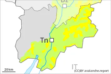
Increase in avalanche danger as a consequence of new snow and wind. Fresh wind slabs represent the main danger. Weak layers in the lower part of the snowpack necessitate caution.
The fresh wind slabs will become increasingly prone to triggering. They can be released easily by a single winter sport participant in all aspects above the tree line. Avalanches can also reach medium size.
The avalanche prone locations are to be found in particular in gullies and bowls, and behind abrupt changes in the terrain. At elevated altitudes the avalanche danger is a little higher. Whumpfing sounds and the formation of shooting cracks when stepping on the snowpack can indicate the danger.
Avalanches can in some cases penetrate deep layers. Caution is to be exercised in particular on very steep northwest, north and east facing slopes above approximately 2200 m.
As a consequence of the new snow more frequent loose snow avalanches are to be expected. On very steep grassy slopes individual gliding avalanches are possible, but they will be mostly small.
Snowpack
dp.6: cold, loose snow and wind
dp.1: deep persistent weak layer
In some regions up to 15 cm of snow fell on Sunday. Up to 15 cm of snow will fall on Monday. As a consequence of a gathering storm force wind from northerly directions, easily released wind slabs will form in the course of the day over a wide area. The fresh snow as well as the wind slabs are lying on top of a weakly bonded old snowpack especially on west to north to southeast facing aspects. The snowpack will be subject to considerable local variations.
Tendency
Fresh wind slabs represent the main danger. Weak layers in the old snowpack necessitate caution.