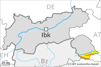
The avalanche conditions are unfavourable. Avalanches can be released very easily.
In particular on steep shady slopes avalanches can be triggered in deep layers of the snowpack and reach large size, in particular in little used terrain above approximately 2000 m. The number and size of avalanche prone locations will increase with altitude. Individual natural avalanches are possible. Avalanches can additionally be released in near-surface layers by small loads. Avalanches can penetrate near-ground layers of the snowpack. The avalanche danger along the border with Veneto and in the regions neighbouring those that are subject to danger level 4 (high) is within the upper range of danger level 3 (considerable).
More frequent small to medium-sized dry loose snow avalanches are to be expected. In the event of prolonged bright spells this applies on extremely steep slopes, in particular.
On steep grassy slopes more frequent small and, in isolated cases, medium-sized gliding avalanches are possible as a consequence of the new snow.
Snowpack
dp.1: deep persistent weak layer dp.6: cold, loose snow and wind
40 to 80 cm of snow has fallen since Wednesday. 5 to 15 cm of snow will fall on Saturday. This applies at high altitudes and in high Alpine regions. The wind will transport only a little snow. Faceted weak layers exist deeper in the old snowpack in particular on steep shady slopes. They are prone to triggering in particular on west to north to northeast facing aspects above approximately 2000 m. The various wind slabs are lying on soft layers at elevated altitudes. The old snowpack will be moist at low and intermediate altitudes.
Tendency
Wind slabs and weakly bonded old snow are to be critically assessed.
Danger level
2000m
Avalanche Problem
Persistent weak layer
2000m
Wind slab
2000m
Wind slabs and weakly bonded old snow require caution.
Weak layers in the old snowpack can be released by winter sport participants on very steep west, north and northeast facing slopes. The avalanche prone locations are to be found in particular on little used shady slopes above approximately 2000 m and on very steep west facing slopes above approximately 2400 m. Avalanches can reach medium size. Individual natural avalanches are possible. Caution is to be exercised in particular in the regions exposed to heavier precipitation. As a consequence of new snow and a moderate to strong wind from southerly directions, further wind slabs will form on Saturday. The number and size of avalanche prone locations will increase with altitude. The avalanche prone locations are barely recognisable because of the poor visibility.
Dry loose snow avalanches are to be expected, in the event of prolonged bright spells especially on extremely steep slopes.
On steep grassy slopes individual small and, in isolated cases, medium-sized gliding avalanches are possible.
Snowpack
dp.5: snowfall after a long period of cold dp.6: cold, loose snow and wind
20 to 50 cm of snow, and even more in some localities, has fallen since Wednesday. 5 to 15 cm of snow, and up to 30 cm in some localities, will fall on Saturday. This applies at high altitudes and in high Alpine regions. The wind will transport the new snow. Weak layers exist in the centre of the old snowpack in particular on little used shady slopes. They are prone to triggering in particular on west to north to northeast facing aspects. The various wind slabs are lying on soft layers at elevated altitudes. The old snowpack will be moist at low and intermediate altitudes. Only a small amount of snow is lying for the time of year.
Tendency
Wind slabs and weakly bonded old snow require caution.
Danger level
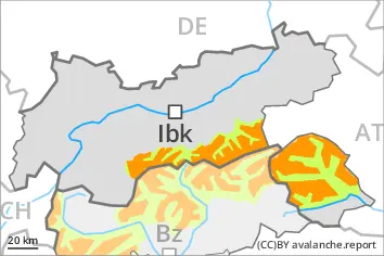
2000m
Avalanche Problem
Wind slab
2000m
Fresh wind slabs require caution. Loose snow avalanches are possible on extremely steep slopes.
Fresh wind slabs are in some cases prone to triggering. The avalanche prone locations are to be found in particular on near-ridge shady slopes. The number and size of avalanche prone locations will increase with altitude. They are sometimes covered with new snow and are barely recognisable because of the poor visibility. Avalanches can in isolated cases reach medium size.
On extremely steep slopes small to medium-sized dry loose snow avalanches are possible. In the event of prolonged bright spells this applies in all aspects, in particular.
On steep grassy slopes individual small to medium-sized gliding avalanches are possible. This applies in particular below approximately 2400 m.
Snowpack
dp.6: cold, loose snow and wind
20 to 40 cm of snow has fallen since Wednesday above approximately 2000 m. As a consequence of new snow and a moderate to strong wind from southerly directions, soft wind slabs formed especially adjacent to ridgelines and in pass areas. The wind slabs will be deposited on the unfavourable surface of an old snowpack on very steep shady slopes at elevated altitudes. Towards its base, the snowpack is largely stable. The old snowpack will be moist at low and intermediate altitudes. Only a small amount of snow is lying for the time of year.
Tendency
Fresh wind slabs represent the main danger.
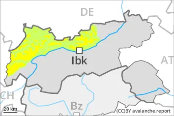
Danger level
2000m
Avalanche Problem
Wind slab
2000m
Fresh wind slabs at high altitude.
Fresh wind slabs are in some cases prone to triggering. This applies in particular on very steep shady slopes adjacent to ridgelines and in gullies and bowls at high altitudes and in high Alpine regions. The avalanche prone locations are sometimes covered with new snow and are barely recognisable because of the poor visibility. In the south the avalanche prone locations are more prevalent. Avalanches can reach medium size in isolated cases, especially in the regions exposed to heavier precipitation.
Weak layers in the old snowpack can be released in isolated cases. The avalanche prone locations are to be found in particular in little used backcountry terrain above approximately 2400 m, especially on very steep shady slopes.
Individual mostly small dry loose snow avalanches are possible. In the regions exposed to heavier precipitation this applies on extremely steep slopes.
Snowpack
dp.6: cold, loose snow and wind dp.5: snowfall after a long period of cold
Over a wide area 10 to 20 cm of snow, and even more in some localities, has fallen since Wednesday above approximately 2000 m. The wind has transported the new snow. The wind will be moderate to strong adjacent to ridgelines in particular in the south. The fresh wind slabs are lying on soft layers in particular on shady slopes at elevated altitudes.
Only a small amount of snow is lying for the time of year.
Tendency
Fresh wind slabs represent the main danger.
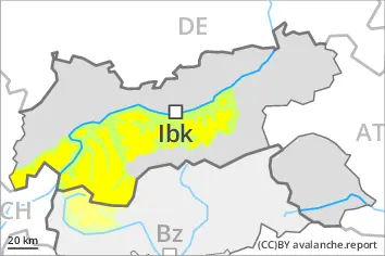
Danger level
A generally favourable avalanche situation will prevail.
Fresh wind slabs are small and can only be released in isolated cases. Individual avalanche prone locations are to be found on very steep shady slopes at elevated altitudes, in particular adjacent to ridgelines.
Individual dry loose snow avalanches are possible. In the event of prolonged bright spells this applies on extremely steep slopes, especially in the regions exposed to heavier precipitation. Mostly the avalanches are small.
Snowpack
10 to 20 cm of snow, and even more in some localities, has fallen since Wednesday. The wind was light to moderate. The snowpack is largely stable; its surface consists of loosely bonded snow. The old snowpack will be moist at low and intermediate altitudes. Only a small amount of snow is lying for the time of year.
Tendency
The avalanche conditions are generally favourable.