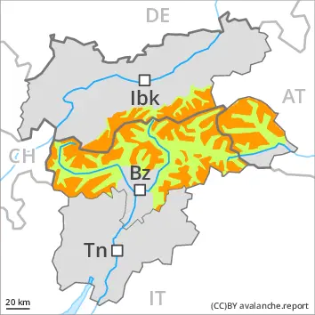
The avalanche conditions are to some extent unfavourable.
Avalanches can in some cases be released in the old snowpack and reach large size in isolated cases. The avalanche prone locations are to be found in particular on little used shady slopes above approximately 2200 m and on very steep west facing slopes above approximately 2400 m. The avalanche prone locations are barely recognisable, even to the trained eye. In some cases avalanches can release the moist old snow as well.
Fresh wind slabs can be released easily in some places in particular on very steep shady slopes above approximately 2400 m. The avalanche prone locations are to be found in particular in gullies and bowls, and behind abrupt changes in the terrain. The number and size of avalanche prone locations will increase with altitude. The wind slabs are clearly recognisable to the trained eye. Avalanches can reach medium size.
On steep grassy slopes and below approximately 2400 m small and medium-sized gliding avalanches are possible as a consequence of the new snow. This applies in the regions exposed to heavier precipitation in the south. Areas with glide cracks are to be avoided as far as possible.
Small to medium-sized loose snow avalanches are possible, in the event of solar radiation especially on extremely steep sunny slopes.
Snowpack
dp.7: snow-poor zones in snow-rich surrounding dp.6: cold, loose snow and wind
As a consequence of a sometimes strong wind from northerly directions, wind slabs will form on Monday especially in gullies and bowls and behind abrupt changes in the terrain. The fresh wind slabs will be deposited on soft layers especially on shady slopes at elevated altitudes. Avalanche prone weak layers exist deeper in the snowpack especially on little used shady slopes. The old snowpack will be moist at low and intermediate altitudes. The high humditiy gave rise to moistening of the snowpack in some cases also at high altitude.
Tendency
The weather conditions will facilitate a gradual settling of the snowpack.
Danger level
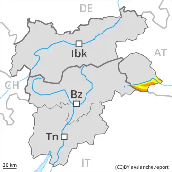
2200m
Avalanche Problem
Persistent weak layer
2200m
Wind slab
2400m
Weakly bonded old snow requires caution. Fresh wind slabs at elevated altitudes.
Weak layers in the old snowpack can still be released by individual winter sport participants. The avalanche prone locations are to be found in particular on little used shady slopes above approximately 2200 m and on very steep west facing slopes above approximately 2400 m. Whumpfing sounds and the formation of shooting cracks when stepping on the snowpack can indicate the danger. Avalanches can reach medium size.
Fresh wind slabs can be released by a single winter sport participant in particular on steep shady slopes above approximately 2400 m. The avalanche prone locations are to be found especially adjacent to ridgelines and in gullies and bowls, and behind abrupt changes in the terrain. The number and size of avalanche prone locations will increase with altitude. Individual avalanche prone locations are to be found also on sunny slopes in high Alpine regions.
Small to medium-sized loose snow avalanches are possible, in the event of prolonged bright spells especially on extremely steep slopes.
On steep grassy slopes individual small to medium-sized gliding avalanches are possible.
Snowpack
dp.5: snowfall after a long period of cold dp.6: cold, loose snow and wind
As a consequence of a sometimes strong wind from northerly directions, wind slabs will form on Monday especially in gullies and bowls and behind abrupt changes in the terrain. The fresh wind slabs will be deposited on soft layers especially on shady slopes at elevated altitudes. Avalanche prone weak layers exist in the centre of the old snowpack especially on little used shady slopes. The old snowpack will be moist at low and intermediate altitudes. The high humditiy gave rise to moistening of the snowpack in some cases also at high altitude. Only a small amount of snow is lying for the time of year.
Tendency
The weather conditions will facilitate a stabilisation of the snowpack. Wind slabs and weakly bonded old snow require caution.
Danger level
2000m
Avalanche Problem
Wind slab
2000m
New snow
Treeline
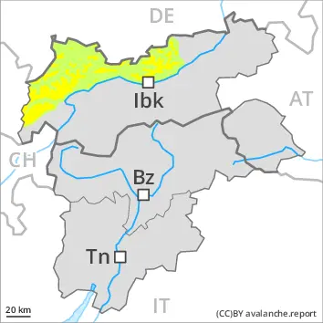
New snow and wind slabs represent the main danger.
Over a wide area 10 to 25 cm of snow, and even more in some localities, has fallen above approximately 1800 m. Gradual increase in avalanche danger as a consequence of new snow and wind. Avalanches can occur easily or triggered naturally. This applies even in case of a small load. The avalanche prone locations are to be found in all aspects above approximately 2000 m and in gullies and bowls, and behind abrupt changes in the terrain. In the regions exposed to heavier precipitation caution is to be exercised in particular at the base of rock walls. Wind-loaded slopes where weaknesses exist in the old snowpack are unfavourable. At transitions from a shallow to a deep snowpack, when entering gullies and bowls for example the avalanche prone locations are more prevalent. In the regions exposed to heavier precipitation the avalanche situation is dangerous. Medium-sized avalanches are possible. Careful route selection and spacing between individuals are recommended.
Snowpack
dp.6: cold, loose snow and wind
The new snow and wind slabs are bonding poorly with the old snowpack on steep shady slopes above approximately 2000 m. The fresh wind slabs will be covered with new snow and therefore difficult to recognise. The old snowpack will be moist at low and intermediate altitudes. Only a small amount of snow is lying for the time of year.
Tendency
The prevalence of avalanche prone locations and likelihood of triggering will increase with altitude.
Danger level
2400m
Avalanche Problem
Wind slab
2400m
Gliding snow
2400m
Wind slabs and gliding snow require caution.
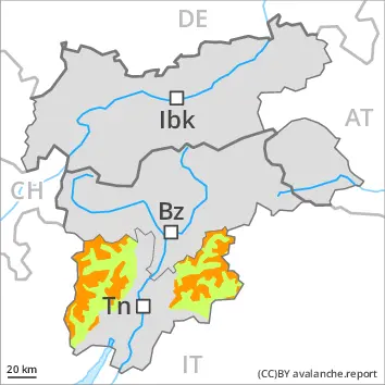
Fresh wind slabs are in some cases prone to triggering. The avalanche prone locations are to be found in particular on near-ridge north and west facing slopes above approximately 2400 m. Their prevalence will increase with altitude. Avalanches can in isolated cases reach medium size.
On steep grassy slopes small to medium-sized gliding avalanches are possible. This applies in particular below approximately 2400 m.
On extremely steep slopes individual small to medium-sized moist loose snow avalanches are possible. In the event of prolonged bright spells this applies in all aspects, in particular.
Snowpack
dp.6: cold, loose snow and wind dp.2: gliding snow
As a consequence of a moderate wind from easterly directions, mostly small wind slabs will form on Monday especially adjacent to ridgelines. Fresh wind slabs are lying on unfavourable layers on steep shady slopes at elevated altitudes. Towards its base, the snowpack is largely stable. The old snowpack will be moist at low and intermediate altitudes. The high humditiy gave rise to moistening of the snowpack in some cases also at high altitude.
Tendency
The weather conditions will facilitate a gradual stabilisation of the snow drift accumulations.
Danger level
2000m
Avalanche Problem
Wind slab
2000m
Fresh wind slabs require caution.
Fresh wind slabs are in some cases prone to triggering. Caution is to be exercised in particular on very steep shady slopes adjacent to ridgelines and in gullies and bowls above approximately 2000 m. In very isolated cases avalanches are medium-sized.
The avalanche prone locations are to be found in particular in little used backcountry terrain.
Individual loose snow avalanches are possible. In the event of prolonged bright spells this applies on extremely steep slopes.
Snowpack
dp.6: cold, loose snow and wind
In some regions up to 20 cm of snow, and even more in some localities, fell in the last few days above approximately 2000 m.
In the last few days the wind was moderate to strong at times. The wind has transported the new snow. The fresh wind slabs are lying on soft layers in particular on shady slopes at elevated altitudes.
The snowpack will be moist at low and intermediate altitudes. Only a small amount of snow is lying for the time of year.
Tendency
The weather conditions will facilitate a stabilisation of the snowpack.
Danger level
2400m
Avalanche Problem
Wind slab
2400m
Fresh wind slabs at high altitude.
The fresh and somewhat older wind slabs are in some cases prone to triggering. This applies in particular on very steep north and west facing slopes adjacent to ridgelines and in pass areas above approximately 2400 m. Avalanches can reach medium size in isolated cases. At elevated altitudes and in the regions neighbouring those that are subject to danger level 3 (considerable) the avalanche prone locations are more prevalent.
Weak layers in the old snowpack can still be released in very isolated cases. The avalanche prone locations are to be found in little used backcountry terrain above approximately 2200 m, especially on very steep shady slopes.
Only isolated mostly small loose snow avalanches are possible. In the event of prolonged bright spells this applies on extremely steep slopes.
Snowpack
dp.6: cold, loose snow and wind dp.5: snowfall after a long period of cold
As a consequence of a moderate wind from easterly directions, mostly small wind slabs will form on Monday especially adjacent to ridgelines. Fresh and somewhat older wind slabs are lying on unfavourable layers on steep shady slopes at elevated altitudes. Faceted weak layers exist deeper in the old snowpack on little used shady slopes. The old snowpack will be moist at low and intermediate altitudes. The high humditiy gave rise to moistening of the snowpack in some cases also at high altitude.
Only a small amount of snow is lying for the time of year.
Tendency
The weather conditions will facilitate a gradual stabilisation of the snow drift accumulations.
Danger level
A generally favourable avalanche situation will prevail.
Fresh wind slabs are small and can only be released in isolated cases. Individual avalanche prone locations are to be found on extremely steep shady slopes at elevated altitudes, in particular adjacent to ridgelines.
Individual small gliding avalanches and moist snow slides are possible. In the event of prolonged bright spells this applies on extremely steep slopes.
Snowpack
As a consequence of a moderate wind from easterly directions, small wind slabs will form on Monday adjacent to ridgelines. The snowpack is largely stable. The old snowpack will be wet all the way through at intermediate altitudes. The high humditiy gave rise to moistening of the snowpack in some cases also in the vicinity of peaks.
Tendency
The avalanche conditions are generally favourable.