Danger level
 | 2200m |
|  |
|  | ||||
|  |
|  |


![]()
Weak layers in the old snowpack represent the main danger. Slight increase in danger of wet avalanches.
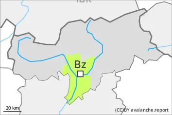
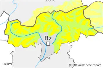
Weak layers in the old snowpack can still be released in some places by individual winter sport participants. The avalanche prone locations are to be found in particular on steep, little used shady slopes above approximately 2200 m. Individual avalanche prone locations are to be found also on sunny slopes in high Alpine regions.
Mostly avalanches are medium-sized. In isolated cases avalanches can also release deeper layers of the snowpack and reach large size.
The avalanche prone locations are barely recognisable, even to the trained eye. The current avalanche situation calls for meticulous route selection.
On very steep slopes small and, in isolated cases, medium-sized wet loose snow avalanches are possible.
Snowpack
dp.5: snowfall after a long period of cold
dp.10: springtime scenario
In some regions up to 10 cm of snow will fall. Up to 1800 m and above rain will fall in some regions.
The new snow and wind slabs of last week are lying on the unfavourable surface of an old snowpack in particular on shady slopes at elevated altitudes.
Avalanche prone weak layers exist in the old snowpack especially on little used shady slopes. The somewhat older wind slabs are now only very rarely prone to triggering.
Sunny slopes:
As a consequence of mild temperatures and very cloudy skies no crust will develop on the surface during the course of the night. The spring-like weather conditions will give rise to increasing softening of the snowpack. Below the tree line only a little snow is now lying.
Tendency
Some snow will fall. Weakly bonded old snow and wet snow require caution. The surface of the snowpack will cool hardly at all during the overcast night and will soften quickly.