Fresh wind slabs at elevated altitudes. Slight increase in danger of wet avalanches as a consequence of warming during the day.
As a consequence of a sometimes strong southerly foehn wind, avalanche prone wind slabs will form in some cases. Such avalanche prone locations for dry avalanches are to be found on very steep shady slopes at elevated altitudes, in particular adjacent to ridgelines, as well as at the base of rock walls and behind abrupt changes in the terrain. In regions exposed to the foehn wind these avalanche prone locations are a little more prevalent.
As a consequence of warming during the day, the likelihood of wet loose snow avalanches being released will increase. On very steep slopes individual mostly small wet loose snow avalanches are possible from late morning. An increasing number of small and, in isolated cases, medium-sized gliding avalanches are possible as the penetration by moisture increases.
Snowpack
dp.6: cold, loose snow and wind dp.10: springtime scenario
As a consequence of a sometimes strong southerly foehn wind, small wind slabs will form in the regions exposed to the foehn wind. Faceted weak layers exist deeper in the old snowpack on little used shady slopes.
Sunshine and high temperatures will give rise as the day progresses to increasing softening of the snowpack. Below the tree line only a little snow is now lying.
Tendency
As a consequence of mild temperatures the snow drift accumulations will stabilise during the next few days. Some rain will fall in some regions.
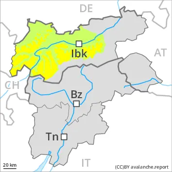
Danger level
2200m
Avalanche Problem
Persistent weak layer
2200m
Wind slab
2600m
Wet snow
2200m
Weak layers in the old snowpack represent the main danger. Fresh wind slabs in high Alpine regions.
Weak layers in the old snowpack can still be released in some places by individual winter sport participants. The avalanche prone locations are to be found in particular on steep, little used shady slopes above approximately 2200 m. Individual avalanche prone locations are to be found also on sunny slopes in high Alpine regions. Mostly avalanches are medium-sized. In isolated cases avalanches can also release deeper layers of the snowpack and reach large size.
In addition the fresh wind slabs should be taken into account, in particular on steep shady slopes adjacent to ridgelines at elevated altitudes.
On very steep slopes small and, in isolated cases, medium-sized wet loose snow avalanches are possible below approximately 2200 m, in the regions exposed to rain especially.
Snowpack
dp.5: snowfall after a long period of cold dp.10: springtime scenario
Up to 10 cm of snow will fall. Up to 2000 m rain will fall in some regions.
Avalanche prone weak layers exist in the old snowpack especially on little used shady slopes. As a consequence of new snow and a moderate to strong southwesterly wind, mostly small wind slabs will form adjacent to ridgelines.
As a consequence of mild temperatures and very cloudy skies no crust will develop on the surface during the course of the night. The weather conditions will give rise to increasing softening of the snowpack at low and intermediate altitudes. Below the tree line only a little snow is now lying.
Tendency
Weakly bonded old snow and wet snow require caution. The surface of the snowpack will cool hardly at all during the overcast night and will soften quickly.
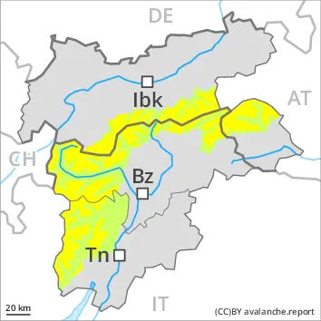
Danger level
2200m
Avalanche Problem
Persistent weak layer
2200m
Wet snow
2200m
Weak layers in the old snowpack represent the main danger. Wet small and medium sized avalanches are possible in isolated cases.
Weak layers in the old snowpack can still be released in some places by individual winter sport participants. The avalanche prone locations are to be found in particular on steep, little used shady slopes above approximately 2200 m. Individual avalanche prone locations are to be found also on sunny slopes in high Alpine regions. Mostly avalanches are medium-sized. In isolated cases avalanches can also release deeper layers of the snowpack and reach large size.
In addition the mostly small wind slabs should be taken into account, in particular on steep shady slopes at elevated altitudes.
On very steep slopes small and, in isolated cases, medium-sized gliding avalanches and wet snow slides are possible below approximately 2200 m, in the regions exposed to rain especially.
Snowpack
dp.5: snowfall after a long period of cold dp.10: springtime scenario
Up to 10 cm of snow will fall. Up to 2000 m rain will fall in some regions.
Avalanche prone weak layers exist in the old snowpack especially on little used shady slopes. As a consequence of new snow and a moderate to strong southwesterly wind, mostly small wind slabs will form adjacent to ridgelines.
As a consequence of mild temperatures and very cloudy skies no crust will develop on the surface during the course of the night. The weather conditions will give rise to increasing softening of the snowpack at low and intermediate altitudes. Below the tree line only a little snow is now lying.
Tendency
Weakly bonded old snow and wet snow require caution. The surface of the snowpack will cool hardly at all during the overcast night and will soften quickly.
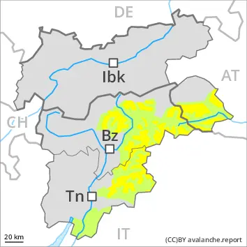
Danger level
Avalanche Problem
Wet snow
Slight increase in danger of wet avalanches as a consequence of warming during the day. Fresh wind slabs at elevated altitudes.
As a consequence of warming during the day, the likelihood of wet loose snow avalanches being released will increase. On very steep slopes individual small and, in isolated cases, medium-sized wet loose snow avalanches are possible. This applies in particular in the regions with a lot of snow. In addition individual gliding avalanches are possible.
Snowpack
dp.10: springtime scenario
The somewhat older wind slabs have bonded well with the old snowpack.
Sunshine and high temperatures will give rise as the day progresses to increasing softening of the snowpack. Below the tree line only a little snow is now lying.
Tendency
As a consequence of mild temperatures the snow drift accumulations will stabilise during the next few days. Some rain will fall in some regions.
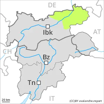
Danger level
Avalanche Problem
Wet snow
Persistent weak layer
2000m
Weakly bonded old snow and wet snow require caution.
On very steep slopes individual mostly small wet loose snow avalanches are possible.
Shady slopes: Avalanches can in very isolated cases be released by a single winter sport participant. The avalanche prone locations are to be found in particular on steep, little used shady slopes above approximately 2000 m. Mostly avalanches are small.
Snowpack
dp.3: rain
Up to 1800 m and above rain will fall.
Isolated avalanche prone weak layers exist in the old snowpack especially on little used shady slopes.
As a consequence of mild temperatures and very cloudy skies no crust will develop on the surface during the course of the night. The weather conditions will give rise to increasing moistening of the snowpack. Below the tree line only a little snow is now lying.
Tendency
Some snow will fall. Weakly bonded old snow and wet snow require caution. The surface of the snowpack will cool hardly at all during the overcast night and will already be soft in the early morning.