Wind slabs represent the main danger. Weak layers in the old snowpack are treacherous. Moist and wet avalanches require caution.
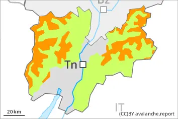
Several medium-sized and, in isolated cases, large slab avalanches are possible in particular on wind-loaded slopes. Weak layers in the old snowpack can still be released in some places by individual winter sport participants. From early morning the likelihood of natural moist avalanches being released will increase gradually below approximately 2600 m. The avalanche prone locations are to be found in particular on steep, little used slopes above approximately 1700 m. The avalanche prone locations are barely recognisable, even to the trained eye. The current avalanche situation calls for great caution and restraint.
Snowpack
dp.5: snowfall after a long period of cold dp.10: springtime scenario
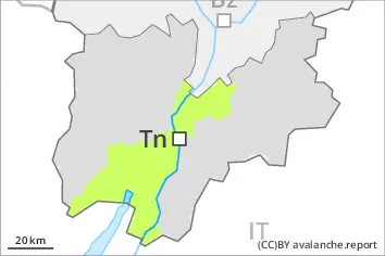
The wind slabs of last week are poorly bonded with the old snowpack. Precarious weak layers exist deep in the old snowpack on little used shady slopes. In addition the danger of moist and wet avalanches will increase as the day progresses.
Tendency
Thursday: The avalanche danger will persist.
EARLIER Danger level
2200m
Avalanche Problem
Wet snow
2200m
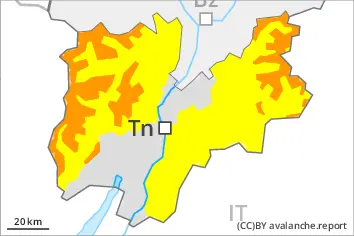
LATER Danger level
1700m
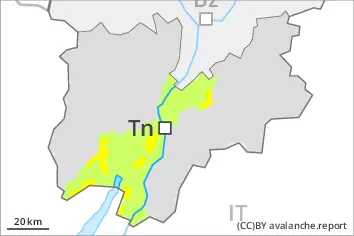
Avalanche Problem
Wet snow
1700m
Moist and wet avalanches require caution. Weak layers in the old snowpack are treacherous.
From early morning the likelihood of natural moist avalanches being released will increase gradually in all altitude zones. Weak layers in the old snowpack can still be released in some places by individual winter sport participants. The avalanche prone locations are to be found in particular on steep, little used slopes above approximately 1700 m. The current avalanche situation calls for careful route selection.
Snowpack
dp.10: springtime scenario
As a consequence of warming during the day and solar radiation there will be an increase in the danger of moist and wet avalanches to level 2 (moderate). Precarious weak layers exist deep in the old snowpack on little used shady slopes.