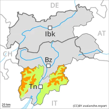
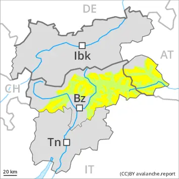
Wind slabs represent the main danger. Weak layers in the old snowpack are treacherous. Moist and wet avalanches require caution.
Several medium-sized and, in isolated cases, large slab avalanches are possible in particular on wind-loaded slopes. Weak layers in the old snowpack can still be released in some places by individual winter sport participants. From early morning the likelihood of natural moist avalanches being released will increase gradually below approximately 2600 m. The avalanche prone locations are to be found especially at the base of rock walls and behind abrupt changes in the terrain, and in gullies and bowls. The avalanche prone locations are difficult to recognise. The current avalanche situation calls for great caution and restraint.
Snowpack
dp.1: deep persistent weak layer dp.10: springtime scenario
The wind slabs of recent weeks are poorly bonded with the old snowpack. Precarious weak layers exist deep in the old snowpack on little used shady slopes. In addition the danger of moist and wet avalanches will increase as the day progresses.
Tendency
Friday: The avalanche danger will decrease.
Danger level
2800m
Avalanche Problem
Wet snow
2800m
Persistent weak layer
2200m
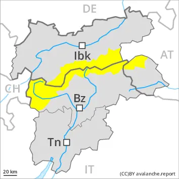
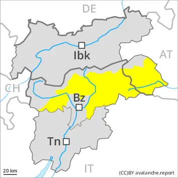
Weakly bonded old snow and wet snow require caution. Wind slabs in high Alpine regions.
Small and medium-sized wet and gliding avalanches are possible as the penetration by moisture increases. This applies in particular on steep north and east facing slopes below approximately 2400 m, and elsewhere below approximately 2800 m.
Weak layers in the old snowpack can still be released in some places by individual winter sport participants. The avalanche prone locations are to be found in particular on steep, little used west, north and east facing slopes above approximately 2200 m. Mostly avalanches are medium-sized. In isolated cases avalanches can also release deeper layers of the snowpack and reach large size.
In addition the mostly small wind slabs should be taken into account, in particular on very steep shady slopes adjacent to ridgelines in high Alpine regions. Restraint should be exercised because avalanches can sweep people along and give rise to falls.
Snowpack
dp.10: springtime scenario dp.5: snowfall after a long period of cold
The surface of the snowpack will cool hardly at all during the overcast night and will soften quickly. The weather conditions will give rise to increasing and thorough wetting of the snowpack at intermediate and high altitudes.
Avalanche prone weak layers exist in the old snowpack especially on little used west, north and east facing slopes. The mostly small wind slabs are lying on soft layers in particular on very steep shady slopes in high Alpine regions.
The snowpack will be generally subject to considerable local variations. Below the tree line only a little snow is now lying.
Tendency
Moderate avalanche danger will prevail. Weakly bonded old snow and wet snow require caution.
Danger level
Avalanche Problem
Wet snow
Wet and gliding avalanches require caution.
On extremely steep slopes individual small and, in isolated cases, medium-sized wet loose snow avalanches are possible. In addition individual gliding avalanches are possible. This applies in particular in the regions with a lot of snow.
Snowpack
dp.10: springtime scenario
The surface of the snowpack will cool hardly at all during the overcast night and will soften quickly. The weather conditions as the day progresses will give rise to increasing and thorough wetting of the snowpack.
The snowpack will be generally subject to considerable local variations. Below the tree line only a little snow is now lying.
Tendency
Sunshine and high temperatures will give rise as the day progresses to softening of the snowpack.
EARLIER Danger level
2200m
Avalanche Problem
Wet snow
2200m
Persistent weak layer
2200m
LATER Danger level
2600m
Avalanche Problem
Wet snow
2600m
Persistent weak layer
2200m
Increase in danger of wet avalanches as a consequence of warming during the day and solar radiation. Weakly bonded old snow requires caution.
An increasing number of small and medium-sized wet and gliding avalanches are possible as a consequence of warming during the day and solar radiation. This applies in particular on steep north and east facing slopes below approximately 2200 m, and elsewhere below approximately 2600 m.
Weak layers in the old snowpack can still be released in some places by individual winter sport participants. The avalanche prone locations are to be found in particular on steep, little used west, north and east facing slopes above approximately 2200 m. Mostly avalanches are medium-sized. In isolated cases avalanches can also release deeper layers of the snowpack and reach large size.
In addition the mostly small wind slabs should be taken into account, in particular on very steep shady slopes adjacent to ridgelines in high Alpine regions. Restraint should be exercised because avalanches can sweep people along and give rise to falls.
Snowpack
dp.10: springtime scenario dp.5: snowfall after a long period of cold
The surface of the snowpack will freeze to form a strong crust. Sunshine and high temperatures will give rise as the day progresses to increasing softening of the snowpack at intermediate and high altitudes.
Avalanche prone weak layers exist in the old snowpack especially on little used west, north and east facing slopes. The mostly small wind slabs are lying on soft layers in particular on very steep shady slopes in high Alpine regions.
The snowpack will be generally subject to considerable local variations. Below the tree line only a little snow is now lying.
Tendency
Moderate avalanche danger will prevail. Weakly bonded old snow and wet snow require caution.
Danger level
2800m
Avalanche Problem
Wet snow
2800m
Gliding snow
2600m
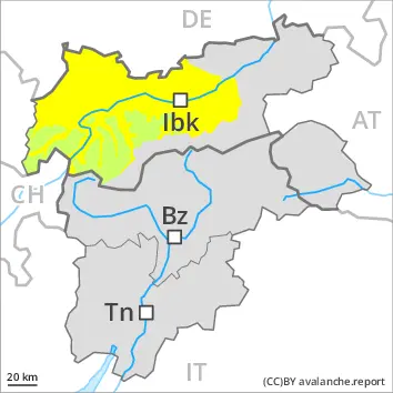
Wet and gliding avalanches require caution.
Small and medium-sized wet and gliding avalanches are possible as the penetration by moisture increases. This applies in particular on steep north and east facing slopes below approximately 2400 m, and elsewhere below approximately 2800 m.
In addition the mostly small wind slabs adjacent to ridgelines on north facing slopes are capable of being triggered in very isolated cases still, in particular in high Alpine regions. Restraint should be exercised because avalanches can sweep people along and give rise to falls.
Snowpack
dp.10: springtime scenario dp.6: cold, loose snow and wind
The surface of the snowpack will cool hardly at all during the overcast night and will soften quickly. The weather conditions will give rise to increasing and thorough wetting of the snowpack at intermediate and high altitudes.
The somewhat older wind slabs are lying on soft layers in particular on very steep shady slopes at elevated altitudes. Faceted weak layers exist deeper in the old snowpack on little used shady slopes.
The snowpack will be generally subject to considerable local variations. Below the tree line only a little snow is now lying.
Tendency
Sunshine and high temperatures will give rise as the day progresses to increasing softening of the snowpack. Wet snow requires caution.
EARLIER Danger level
Avalanche Problem
Wet snow
LATER Danger level
1700m
Avalanche Problem
Wet snow
1700m
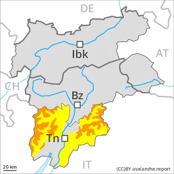
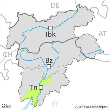
Moist and wet avalanches require caution. Weak layers in the old snowpack are treacherous.
From early morning the likelihood of moist and wet avalanches being released will increase gradually in all altitude zones. Weak layers in the old snowpack can still be released in some places by individual winter sport participants. The avalanche prone locations are to be found in particular on steep, little used slopes above approximately 1700 m. The current avalanche situation calls for careful route selection.
Snowpack
dp.10: springtime scenario
As a consequence of warming during the day and solar radiation there will be an increase in the danger of moist and wet avalanches to level 2 (moderate). Precarious weak layers exist deep in the old snowpack on little used shady slopes.
Tendency
Friday: The avalanche danger will persist.
Danger level
Avalanche Problem
Wet snow
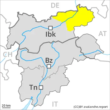
Low avalanche danger will prevail.
On very steep slopes individual mostly small wet loose snow avalanches are possible. Avalanches can in very isolated cases be released by a single winter sport participant. The avalanche prone locations are to be found in particular on very steep shady slopes above approximately 2200 m. Mostly avalanches are small.
Snowpack
At intermediate and high altitudes the snowpack will only just freeze. The weather conditions will give rise to increasing moistening of the snowpack. Isolated avalanche prone weak layers exist in the old snowpack especially on steep shady slopes.
Only a little snow is now lying.
Tendency
Low avalanche danger will prevail. The surface of the snowpack will only just freeze and will soften during the day.