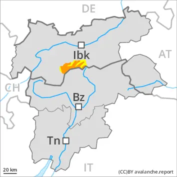
Wind slabs and weakly bonded old snow require caution.
As a consequence of new snow and a strong to storm force wind from northerly directions, avalanche prone wind slabs formed. These are covered with new snow and therefore difficult to recognise. New snow and wind slabs can over a wide area be released by a single winter sport participant. Mostly avalanches are medium-sized. Caution is to be exercised in particular adjacent to ridgelines and in gullies and bowls at high altitudes and in high Alpine regions. Whumpfing sounds and the formation of shooting cracks when stepping on the snowpack can indicate the danger. Wherever the sun appears, the likelihood of natural avalanches being released will increase.
Weak layers in the old snowpack can be released in isolated cases by individual winter sport participants. These avalanche prone locations are to be found in particular on steep, little used shady slopes above approximately 2200 m and on steep, little used west and east facing slopes above approximately 2600 m. Mostly avalanches are medium-sized.
Snowpack
dp.6: cold, loose snow and wind dp.9: graupel blanketed with snow
20 to 40 cm of snow has fallen since Saturday. The fresh snow and the wind slabs formed during the snowfall are lying on soft layers in all aspects above approximately 2000 m. West, south and east facing slopes below approximately 2400 m: The new snow is lying on a crust.
Avalanche prone weak layers exist in the old snowpack especially on little used west, north and east facing slopes. This applies on shady slopes above approximately 2200 m, as well as on west and east facing slopes above approximately 2600 m.
Tendency
Gradual decrease in avalanche danger.
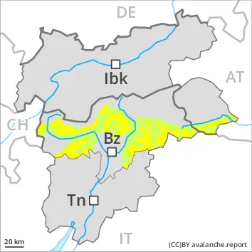
Danger level
2200m
Avalanche Problem
Persistent weak layer
2200m
New snow
2000m
Gliding snow
2400m
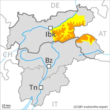
New snow and weakly bonded old snow represent the main danger.
The large quantity of fresh snow as well as the widespread extensive wind slabs can be released easily, even by a single winter sport participant,. These are covered with new snow in some cases and therefore difficult to recognise. Remotely triggered and natural avalanches are possible in isolated cases. Additionally avalanches can also release deeper layers of the snowpack and reach large size. This applies in particular on steep, little used shady slopes above approximately 2200 m, as well as on steep, little used west and east facing slopes above approximately 2600 m.
Gliding avalanches can also occur. This applies on grassy slopes below approximately 2400 m, in the regions exposed to a lot of precipitation especially.
Snowpack
dp.6: cold, loose snow and wind dp.9: graupel blanketed with snow
50 to 80 cm of snow, and up to 100 cm in some localities, fell in the last few days, in particular at high altitudes and in high Alpine regions. The fresh snow and the extensive wind slabs formed during the snowfall are lying on soft layers in all aspects above approximately 2000 m. West, south and east facing slopes below approximately 2400 m: The new snow is lying on a crust.
Avalanche prone weak layers exist in the old snowpack especially on little used west, north and east facing slopes. This applies on shady slopes above approximately 2200 m, as well as on west and east facing slopes above approximately 2600 m.
Tendency
Gradual decrease in avalanche danger.
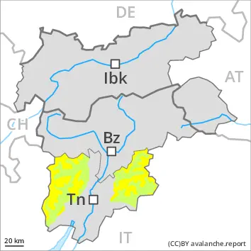
Danger level
2000m
Avalanche Problem
New snow
2000m
Gliding snow
2400m
New snow and wind slabs are to be critically assessed.
As a consequence of new snow and a strong to storm force wind from northerly directions, avalanche prone wind slabs formed. These are covered with new snow and therefore difficult to recognise. New snow and wind slabs can over a wide area be released by a single winter sport participant. Mostly avalanches are medium-sized. Caution is to be exercised in particular adjacent to ridgelines and in gullies and bowls at high altitudes and in high Alpine regions. Whumpfing sounds and the formation of shooting cracks when stepping on the snowpack can indicate the danger. Remotely triggered avalanches are possible in isolated cases. Wherever the sun appears, the likelihood of natural avalanches being released will increase.
Gliding avalanches are also to be expected. This applies on grassy slopes below approximately 2400 m, in the regions exposed to a lot of precipitation especially.
Snowpack
dp.6: cold, loose snow and wind dp.9: graupel blanketed with snow
30 to 50 cm of snow has fallen since Saturday. The fresh snow and the wind slabs formed during the snowfall are lying on soft layers in all aspects above approximately 2000 m. West, south and east facing slopes below approximately 2400 m: The new snow is lying on a crust.
Tendency
Gradual decrease in avalanche danger.
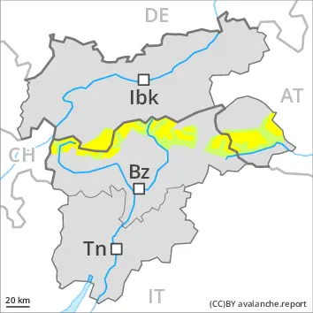
Danger level
treeline
Avalanche Problem
Wind slab
Treeline
Persistent weak layer
2200m
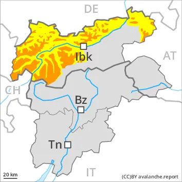
Wind slabs and weakly bonded old snow represent the main danger.
As a consequence of new snow and a sometimes storm force wind from northerly directions, avalanche prone wind slabs formed since Saturday in particular adjacent to ridgelines and in gullies and bowls. These can be released by a single winter sport participant. Caution is to be exercised in particular on steep slopes above the tree line. Weak layers in the upper part of the snowpack can be released by individual winter sport participants. These avalanche prone locations are to be found in particular on steep, little used shady slopes above approximately 2200 m and on steep, little used west and east facing slopes above approximately 2600 m. In isolated cases avalanches can also release deeper layers of the snowpack. Mostly avalanches are medium-sized.
Individual gliding avalanches can also occur. This applies on steep grassy slopes below approximately 2400 m.
Snowpack
dp.6: cold, loose snow and wind dp.9: graupel blanketed with snow
In some regions up to 40 cm of snow has fallen. As a consequence of new snow and strong wind the wind slabs have increased in size additionally. The new snow and wind slabs are lying on soft layers in particular on steep shady slopes above approximately 2200 m.
Avalanche prone weak layers exist in the old snowpack especially on little used west, north and east facing slopes. This applies on shady slopes above approximately 2200 m, as well as on west and east facing slopes above approximately 2600 m.
Tendency
Gradual decrease in avalanche danger.
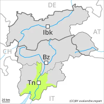
Danger level
2200m
Avalanche Problem
Wind slab
2200m
Persistent weak layer
2200m
Wind slabs and weakly bonded old snow require caution.
More recent wind slabs are to be evaluated with care and prudence in particular on steep west, north and east facing slopes above approximately 2200 m, especially adjacent to ridgelines. Restraint should be exercised because avalanches can sweep people along and give rise to falls.
Weak layers in the old snowpack can still be released in isolated cases by individual winter sport participants. The avalanche prone locations are to be found in particular on steep, little used shady slopes above approximately 2200 m and on steep, little used west and east facing slopes above approximately 2600 m. Mostly avalanches are medium-sized.
Snowpack
dp.6: cold, loose snow and wind
As a consequence of a storm force wind from northerly directions, mostly small wind slabs formed since Saturday especially adjacent to ridgelines. The fresh wind slabs are lying on soft layers.
Avalanche prone weak layers exist in the old snowpack especially on little used west, north and east facing slopes. This applies on shady slopes above approximately 2200 m, as well as on west and east facing slopes above approximately 2600 m.
Tendency
Hardly any change in avalanche danger.
Danger level
1900m
Avalanche Problem
Wind slab
1900m
Persistent weak layer
2200m
Wind slabs and weakly bonded old snow require caution.
Wind slabs can in some places be released by a single winter sport participant. Caution is to be exercised in particular adjacent to ridgelines above approximately 1900 m. Avalanches can in some cases reach medium size. Restraint should be exercised because avalanches can sweep people along and give rise to falls.
Weak layers in the old snowpack can be released in isolated cases by individual winter sport participants. The avalanche prone locations are to be found in particular on steep, little used shady slopes above approximately 2200 m. Mostly avalanches are medium-sized. In isolated cases avalanches can also release deeper layers of the snowpack and reach medium size.
Snowpack
dp.6: cold, loose snow and wind
As a consequence of a storm force wind from northerly directions, mostly small wind slabs formed in the last few days especially adjacent to ridgelines. As a consequence of the strong wind the wind slabs will increase in size moderately as the day progresses. The fresh wind slabs are lying on soft layers. Avalanche prone weak layers exist in the old snowpack especially on little used west, north and east facing slopes. This applies on shady slopes above approximately 2200 m. The snowpack will be subject to considerable local variations at intermediate altitudes. Below the tree line a little snow is lying.
Tendency
Thus far the wind has been strong over a wide area. The weather will be sunny at times. The avalanche danger will persist.
Danger level
2200m
Avalanche Problem
Wind slab
2200m
Persistent weak layer
2200m
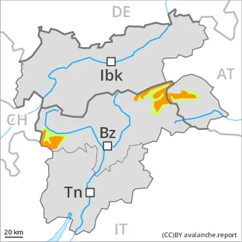
Wind slabs and weakly bonded old snow require caution.
As a consequence of new snow and a storm force wind from northerly directions, avalanche prone wind slabs formed in the last few days especially adjacent to ridgelines. The fresh wind slabs can in some places be released by a single winter sport participant. Caution is to be exercised in particular on steep slopes above approximately 2200 m.
Weak layers in the old snowpack can be released in isolated cases by individual winter sport participants. These avalanche prone locations are to be found in particular on steep, little used shady slopes above approximately 2200 m and on steep, little used west and east facing slopes above approximately 2600 m. Mostly avalanches are medium-sized.
Snowpack
dp.6: cold, loose snow and wind dp.9: graupel blanketed with snow
In some regions up to 20 cm of snow, and even more in some localities, fell in the last few days. The wind was strong to storm force in some regions. The new snow and wind slabs are lying on soft layers in particular on steep shady slopes above approximately 2200 m.
Avalanche prone weak layers exist in the old snowpack especially on little used west, north and east facing slopes. This applies on shady slopes above approximately 2200 m, as well as on west and east facing slopes above approximately 2600 m.
Tendency
Hardly any change in avalanche danger.
Danger level
Low avalanche danger will prevail.
Avalanches can in very isolated cases be released by a single winter sport participant. The avalanche prone locations are to be found in particular on very steep shady slopes above approximately 1900 m. Mostly avalanches are small.
Snowpack
Isolated avalanche prone weak layers exist in the old snowpack especially on steep shady slopes. The snowpack will be generally subject to considerable local variations. Below the tree line a little snow is lying.
Tendency
On Tuesday the wind was strong over a wide area. The weather will be sunny at times. The avalanche danger will persist.
Danger level
Low avalanche danger will prevail.
Avalanches can in very isolated cases be released by a single winter sport participant. The avalanche prone locations are to be found in particular on very steep shady slopes and at elevated altitudes. Mostly avalanches are small.
Snowpack
The surface of the snowpack will only just freeze and will soften quickly. Isolated avalanche prone weak layers exist in the old snowpack especially on steep shady slopes.
The snowpack will be generally subject to considerable local variations. Only a little snow is now lying.