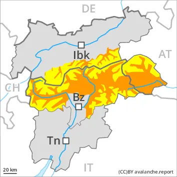
Wet snow represents the main danger. Natural avalanches are to be expected. Fresh wind slabs in the high Alpine regions.
The conditions are unfavourable for backcountry touring. During the course of the night as a consequence of the rain there will be an additional increase in the danger of wet avalanches. This applies in particular below approximately 2800 m. The avalanche danger in particular in the regions exposed to heavier precipitation is within the uppermost range of danger level 3 (considerable). Especially on very steep west, north and east facing slopes and below approximately 2600 m more frequent wet slab avalanches are to be expected as the penetration by moisture increases. These can release the saturated snowpack and reach large size in the regions with a lot of snow. In some cases, the avalanches can reach areas without any snow cover in steep gullies.
Fresh wind slabs can be released by a single winter sport participant in some cases in particular on very steep shady slopes above approximately 2800 m. Such avalanche prone locations are to be found adjacent to ridgelines and in gullies and bowls.
Snowpack
dp.3: rain dp.6: cold, loose snow and wind
The rain will give rise to increasing and thorough wetting of the snowpack at high altitude. This situation will give rise to a loss of strength within the snowpack especially on west, north and east facing slopes.
High Alpine regions: 10 to 30 cm of snow, and even more in some localities, will fall. As a consequence of new snow and a sometimes strong southerly wind, rather small wind slabs will form. These are lying on soft layers on very steep shady slopes.
Tendency
Slight decrease in danger of wet avalanches as a consequence of the ceasing of precipitation. The surface of the snowpack will cool hardly at all during the overcast night will already be soft in the early morning. Wet snow represents the main danger.
Danger level
2800m
Avalanche Problem
Wet snow
2800m
Gliding snow
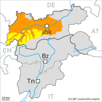
Wet snow represents the main danger. Natural avalanches are possible.
During the night as a consequence of the moist air there will be an additional increase in the danger of wet avalanches. The avalanche prone locations are to be found on sunny slopes below approximately 2800 m and on shady slopes below approximately 2600 m. Especially on very steep west, north and east facing slopes wet slab avalanches are possible as the penetration by moisture increases. These can release the saturated snowpack and reach large size especially in the regions with a lot of snow. In some cases, the avalanches can reach areas without any snow cover in steep gullies.
In addition individual small to medium-sized gliding avalanches are to be expected. This applies in particular on very steep grassy slopes. Areas with glide cracks are to be avoided as far as possible.
Snowpack
dp.10: springtime scenario dp.3: rain
Outgoing longwave radiation during the night will be barely evident. Up to 2600 m and above rain will fall in some regions. The weather conditions will give rise to increasing and thorough wetting of the snowpack below approximately 2800 m. This situation will give rise to a loss of strength within the snowpack especially on west, north and east facing slopes.
Tendency
Outgoing longwave radiation during the night will be quite good. The weather conditions during the night will give rise to slight consolidation of the snowpack.
Danger level
Avalanche Problem
Wet snow
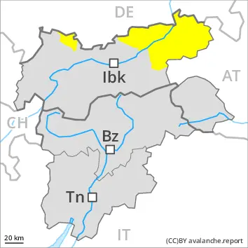
Wet and gliding snow represent the main danger.
Wet avalanches can in some places be released, even by a single winter sport participant or triggered naturally. The avalanche prone locations are to be found on very steep shady slopes below approximately 2600 m and on very steep sunny slopes in all altitude zones. Avalanches can release the saturated snowpack and reach medium size.
Gliding avalanches can also occur at any time. Such avalanche prone locations for gliding avalanches are to be found in particular on very steep grassy slopes.
Snowpack
dp.10: springtime scenario dp.2: gliding snow
Outgoing longwave radiation during the night will be barely evident. Some rain will fall in some regions. The spring-like weather conditions will give rise to increasing and thorough wetting of the snowpack in all aspects.
Tendency
Wet snow represents the main danger.
Danger level
1800m
Avalanche Problem
Wet snow
2800m
1800m
Wind slab
2800m
Wet snow represents the main danger. Wet loose snow avalanches are possible. Fresh wind slabs in the high Alpine regions.
The conditions are unfavourable for backcountry touring. During the course of the night as a consequence of the rain there will be an increase in the danger of wet avalanches. This applies in particular below approximately 2800 m. The avalanche danger in particular in the regions exposed to heavier precipitation is within the uppermost range of danger level 2 (moderate). Especially on very steep west, north and east facing slopes and below approximately 2600 m medium-sized and, in isolated cases, large wet avalanches are to be expected as the penetration by moisture increases. In isolated cases, the avalanches can reach areas without any snow cover in steep gullies.
Fresh wind slabs can be released by a single winter sport participant in some cases in particular on very steep shady slopes above approximately 2800 m. Such avalanche prone locations are to be found adjacent to ridgelines and in gullies and bowls.
Snowpack
dp.3: rain dp.6: cold, loose snow and wind
The rain will give rise to increasing and thorough wetting of the snowpack at high altitude. This situation will give rise to a loss of strength within the snowpack especially on west, north and east facing slopes.
High Alpine regions: 20 to 30 cm of snow, and even more in some localities, will fall. As a consequence of new snow and a sometimes strong southerly wind, rather small wind slabs will form. These are lying on soft layers on very steep shady slopes.
Tendency
Slight decrease in danger of wet avalanches as a consequence of the ceasing of precipitation. The surface of the snowpack will cool hardly at all during the overcast night will already be soft in the early morning. Wet snow represents the main danger.
Danger level
1800m
Avalanche Problem
Wet snow
1800m
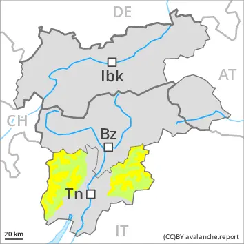
Wet snow represents the main danger.
As a consequence of the precipitation individual wet avalanches are possible, but they will be mostly small. In particular in the Vallarsa medium-sized wet loose snow avalanches are possible in particular above approximately 1800 m.
Snowpack
Outgoing longwave radiation during the night will be severely restricted. The surface of the snowpack will freeze very little and will already be soft in the early morning. The rain will give rise to increasing and thorough wetting of the snowpack. Below approximately 1800 m a little snow is lying.
Tendency
Wet snow requires caution.
Danger level
Avalanche Problem
Wet snow
Wet snow represents the main danger.
As a consequence of the precipitation individual wet avalanches are possible, but they will be mostly small.
Snowpack
Outgoing longwave radiation during the night will be severely restricted. The surface of the snowpack will freeze very little and will already be soft in the early morning. The rain will give rise to increasing and thorough wetting of the snowpack. Only a little snow is now lying.