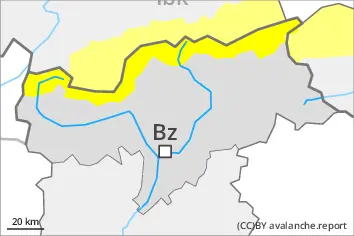
Wet snow represents the main danger. Wind slabs in the high Alpine regions.
Wet avalanches can as before be released by a single winter sport participant. The avalanche prone locations are to be found especially on very steep west, north and east facing slopes below approximately 2800 m. Avalanches can release the saturated snowpack and reach medium size. As a consequence of warming during the day there will be only a slight increase in the danger of wet avalanches. Some rain will fall in the afternoon in some regions. As a consequence of the rain, the likelihood of avalanches being released will increase.
The wind slabs can be released by a single winter sport participant in isolated cases in particular on very steep shady slopes in high Alpine regions. Such avalanche prone locations are to be found adjacent to ridgelines.
Snowpack
dp.10: springtime scenario dp.6: cold, loose snow and wind
The surface of the snowpack will cool hardly at all during the overcast night and will already be soft in the early morning. The snowpack will be wet all the way through. This applies on shady slopes below approximately 2600 m, as well as on sunny slopes below approximately 3000 m. Sunshine and high temperatures will give rise as the day progresses to increasing softening of the snowpack. Up to high altitudes rain will fall in the afternoon in some regions. On steep sunny slopes as well as at low and intermediate altitudes only a little snow is now lying.
High Alpine regions: As a consequence of a strong wind from southeasterly directions, wind slabs formed. These are lying on soft layers on steep shady slopes. The weather effects will foster a rapid strengthening of the snow drift accumulations.
Tendency
The surface of the snowpack will freeze, but a strong crust will not form and will soften during the day. Wet snow requires caution.
EARLIER Danger level
2800m
Avalanche Problem
Wet snow
2800m
Wind slab
2800m
LATER Danger level
2800m
Avalanche Problem
Wet snow
2800m
Wind slab
2800m
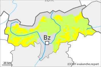
Wet snow represents the main danger. Wind slabs in the high Alpine regions.
As a consequence of warming during the day there will be a gradual increase in the danger of wet avalanches. Some rain will fall in the afternoon in some regions. Wet avalanches can as before be released by a single winter sport participant. As a consequence of the rain, the likelihood of avalanches being released will increase. The avalanche prone locations are to be found especially on very steep west, north and east facing slopes below approximately 2800 m. Avalanches can release the saturated snowpack and reach medium size.
The wind slabs can be released by a single winter sport participant in isolated cases in particular on very steep shady slopes in high Alpine regions. Such avalanche prone locations are to be found in gullies and bowls, and behind abrupt changes in the terrain.
Snowpack
dp.10: springtime scenario dp.6: cold, loose snow and wind
The surface of the snowpack will freeze to form a strong crust and will soften during the day. The snowpack will be wet all the way through. This applies on shady slopes below approximately 2600 m, as well as on sunny slopes below approximately 3000 m. Sunshine and high temperatures will give rise as the day progresses to increasing softening of the snowpack. Up to high altitudes rain will fall in the afternoon in some regions. On steep sunny slopes as well as at low and intermediate altitudes only a little snow is now lying.
High Alpine regions: As a consequence of a strong wind from southeasterly directions, wind slabs formed. These are lying on soft layers on steep shady slopes. The weather effects will foster a rapid strengthening of the snow drift accumulations.
Tendency
The surface of the snowpack will freeze, but a strong crust will not form and will soften during the day. Wet snow requires caution.
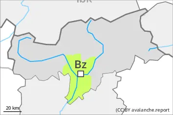
Danger level
Low avalanche danger will prevail.
Only isolated wet avalanches are possible.
Snowpack
Outgoing longwave radiation during the night will be severely restricted. The surface of the snowpack will cool hardly at all during the overcast night and will already be soft in the early morning. The snowpack will be wet all the way through. Only a little snow is now lying.