Backcountry tours should be started and concluded early. The danger of wet avalanches will increase significantly during the day.
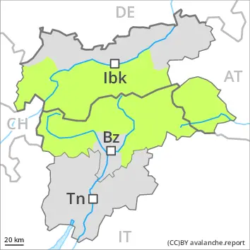
A clear night will be followed in the early morning by favourable conditions, but the danger of wet avalanches will increase later. The avalanche prone locations are to be found on very steep west, north and east facing slopes below approximately 3200 m. Mostly avalanches are only small.
More recent wind slabs can be released in isolated cases, but mostly only by large additional loads,. Individual avalanche prone locations are to be found in particular on very steep shady slopes in high Alpine regions and adjacent to ridgelines and in gullies and bowls. Mostly avalanches are only small.
Backcountry touring calls for experience in the assessment of avalanche danger. Backcountry tours and off-piste skiing should be started and concluded early.
This is the final hazard map for the winter 2024/25. Current information and announcements are posted on our blog. We wish all users of the Euregio Avalanche Report an accident-free summer season.
Snowpack
dp.10: springtime scenario
A clear night. The surface of the snowpack has frozen to form a strong crust only at high altitudes and will soften quickly.
The old snowpack is wet. This applies on shady slopes at intermediate and high altitudes, as well as on sunny slopes in high Alpine regions.
Tendency
Over a wide area a clear night. The surface of the snowpack will freeze to form a strong crust only at high altitudes and will soften during the day.
The weather will be very mild. The conditions remain spring-like.
EARLIER Danger level
LATER Danger level
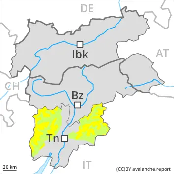
3000m
Avalanche Problem
Wet snow
3000m
Rapid increase in danger of wet avalanches as a consequence of warming during the day and solar radiation.
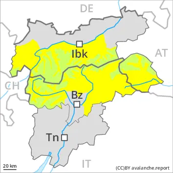
A clear night will be followed in the early morning by favourable conditions generally.
As a consequence of warming during the day and the solar radiation, the likelihood of wet avalanches being released will increase quickly. Mostly they are only small but can be released even by a single winter sport participant. The avalanche prone locations are to be found especially on very steep west, north and east facing slopes below approximately 3000 m and on very steep south facing slopes above approximately 3000 m.
Somewhat older wind slabs are now only very rarely prone to triggering. Very isolated avalanche prone locations are to be found in particular on extremely steep shady slopes in high Alpine regions and adjacent to ridgelines. Mostly avalanches are only small.
The Avalanche Warning Service currently has only a small amount of information that has been collected in the field, so that the avalanche danger should be investigated especially thoroughly in the relevant locality.
This is the final hazard map for the winter 2024/25. Current information and announcements are posted on our blog. We wish all users of the Euregio Avalanche Report an accident-free summer season.
Snowpack
dp.10: springtime scenario
Over a wide area a clear night. The surface of the snowpack will freeze to form a strong crust and will already soften in the late morning. In steep terrain there is a danger of falling on the hard crust. The old snowpack is wet. This applies on shady slopes at intermediate and high altitudes, as well as on sunny slopes in high Alpine regions. In all altitude zones only a little snow is now lying.
Tendency
A clear night will be followed in the early morning by favourable conditions generally, but the danger of wet avalanches will increase later.
Danger level
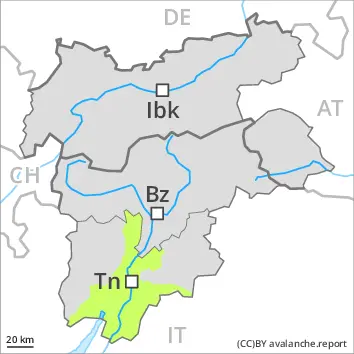
Low avalanche danger will prevail.
Only isolated wet avalanches are possible.
This is the final hazard map for the winter 2024/25. Current information and announcements are posted on our blog. We wish all users of the Euregio Avalanche Report an accident-free summer season.
Snowpack
The surface of the snowpack will soften quickly. The snowpack will be wet all the way through.
A little snow is lying.
Tendency
The weather will be very mild. The conditions remain spring-like.
Danger level
Low avalanche danger will prevail.
Hardly any more avalanches are possible.
Snowpack
A partly clear night. The surface of the snowpack will freeze very little and will soften quickly. The old snowpack will be wet all the way through. A little snow is lying.
Tendency
Hardly any more avalanches are possible.
Danger level
Gradual increase in danger of wet avalanches as a consequence of warming during the day and solar radiation.
A clear night will be followed in the early morning by favourable conditions generally.
The danger of wet avalanches will increase a little during the day. Wet avalanches can in very isolated cases be released by a single winter sport participant. The avalanche prone locations are to be found especially on very steep west, north and east facing slopes at high altitudes and in high Alpine regions. Mostly avalanches are only small.
The Avalanche Warning Service currently has only a small amount of information that has been collected in the field, so that the avalanche danger should be investigated especially thoroughly in the relevant locality.
This is the final hazard map for the winter 2024/25. Current information and announcements are posted on our blog. We wish all users of the Euregio Avalanche Report an accident-free summer season.
Snowpack
dp.10: springtime scenario
Over a wide area a clear night. The surface of the snowpack will freeze to form a strong crust and will already soften in the late morning. In steep terrain there is a danger of falling on the hard crust. The old snowpack is wet.
Tendency
A clear night will be followed in the early morning by favourable conditions generally, but the danger of wet avalanches will increase later.