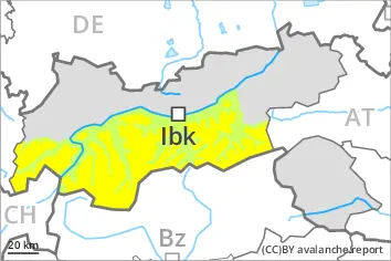
Weakly bonded old snow represents the main danger.
Weak layers in the old snowpack can be released in isolated cases by individual winter sport participants. The avalanche prone locations are to be found on very steep west, north and east facing slopes above approximately 2400 m. As the snowfall level rises the avalanche prone locations will become more prevalent in the afternoon. This applies in particular below approximately 2500 m. Avalanches can reach medium size.
In addition the fresh wind slabs in particular adjacent to ridgelines and in gullies and bowls as well as at high altitudes are prone to triggering. Avalanches are small. Apart from the danger of being buried, restraint should be exercised as well in view of the danger of avalanches sweeping people along and giving rise to falls.
Snowpack
dp.1: deep persistent weak layer dp.6: cold, loose snow and wind
Some snow will fall in the afternoon in some regions.
Faceted weak layers exist in the bottom section of the old snowpack. This applies especially on west, north and east facing slopes at elevated altitudes, in particular in shady places that are protected from the wind.
As a consequence of a moderate wind from westerly directions, mostly small wind slabs will form at high altitudes and in high Alpine regions. The wind slabs are lying on soft layers on shady slopes. They are lying on surface hoar in some places.
Tendency
Increase in avalanche danger as the precipitation becomes more intense. Weakly bonded old snow represents the main danger.
EARLIER Danger level
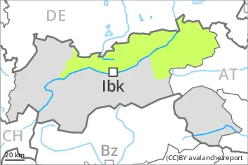
2400m
Avalanche Problem
Wind slab
2400m
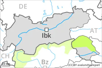
LATER Danger level
2400m
Avalanche Problem
Wind slab
2400m
Slight increase in avalanche danger in the course of the day. Fresh wind slabs represent the main danger.
The fresh wind slabs are mostly small but can in some cases be released easily. The somewhat older wind slabs can be released in isolated cases on very steep shady slopes at elevated altitudes. The avalanche prone locations are to be found adjacent to ridgelines and in gullies and bowls and on very steep shady slopes above approximately 2400 m. The mostly small wind slabs are to be avoided in particular in terrain where there is a danger of falling.
Afternoon: Slight increase in danger of gliding avalanches and snow slides as the snowfall level rises.
Snowpack
dp.6: cold, loose snow and wind dp.2: gliding snow
Up to 2200 m rain will fall in the afternoon in some regions. As a consequence of a moderate to strong wind from westerly directions, sometimes avalanche prone wind slabs will form at high altitudes and in high Alpine regions. The wind slabs are lying on soft layers on shady slopes. They are lying on surface hoar in some places.
Tendency
Further increase in avalanche danger as the precipitation becomes more intense.
Danger level
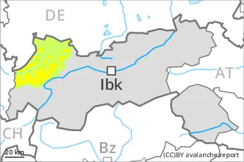
The avalanche prone locations are rare.
The wind slabs can be released in isolated cases in particular on extremely steep shady slopes at elevated altitudes. This applies in gullies and bowls. Such avalanche prone locations are rare. Avalanches are small.
Apart from the danger of being buried, restraint should be exercised in particular in view of the danger of avalanches sweeping people along and giving rise to falls.
Snowpack
The snowpack will be subject to considerable local variations. From a snow sport perspective, in most cases insufficient snow is lying.
Steep shady slopes: In isolated cases wind slabs are lying on a weakly bonded old snowpack.
Tendency
The weather will be mild. A little snow is lying. Low avalanche danger will persist.
Danger level
Wind slabs and gliding snow require caution. Thus far only a little snow is lying.
The fresh and older wind slabs can be released in isolated cases on very steep shady slopes at elevated altitudes. The avalanche prone locations are to be found adjacent to ridgelines and in gullies and bowls. The small wind slabs are to be avoided in particular in terrain where there is a danger of falling.
Afternoon: Slight increase in danger of gliding avalanches and snow slides as the snowfall level rises.
Snowpack
dp.6: cold, loose snow and wind dp.2: gliding snow
Up to 2200 m rain will fall in the afternoon in some regions.
As a consequence of a moderate wind from westerly directions, mostly small wind slabs will form at high altitudes and in high Alpine regions. The wind slabs are lying on soft layers on shady slopes at elevated altitudes. They are lying on surface hoar in some places.
Tendency
Slight increase in avalanche danger as a consequence of the precipitation.
Danger level
2400m
Avalanche Problem
Wind slab
2400m
Individual avalanche prone locations are to be found on very steep shady slopes at elevated altitudes.
The fresh and older wind slabs can be released in isolated cases on very steep shady slopes. Such avalanche prone locations are to be found in gullies and bowls, and behind abrupt changes in the terrain above approximately 2400 m. Avalanches can reach medium size in isolated cases. Apart from the danger of being buried, restraint should be exercised as well in view of the danger of avalanches sweeping people along and giving rise to falls.
Snowpack
dp.6: cold, loose snow and wind dp.1: deep persistent weak layer
Some snow will fall in some regions. As a consequence of a moderate wind from westerly directions, small wind slabs will form. In some cases various wind slab layers are lying on a weakly bonded old snowpack. This applies in particular on shady slopes at elevated altitudes. They are in isolated cases prone to triggering.
The snowpack will be subject to considerable local variations. From a snow sport perspective, in most cases insufficient snow is lying.