A sometimes unfavourable avalanche situation will prevail. Weakly bonded old snow and gliding snow represent the main danger.
Dry avalanches can in some places be released by a single winter sport participant and reach medium size. This applies in particular on very steep west, north and east facing slopes above approximately 2400 m.
More frequent gliding avalanches are possible, even medium-sized ones. Caution is to be exercised in particular on steep grassy slopes below approximately 2400 m.
As a consequence of warming during the day and solar radiation more mostly small wet loose snow avalanches are possible, in particular on extremely steep sunny slopes.
Snowpack
dp.1: deep persistent weak layer dp.2: gliding snow
Below approximately 2600 m: Towards its surface, the snowpack is moist. Below approximately 2000 m: The snowpack is wet all the way through.
Faceted weak layers exist in the bottom section of the old snowpack. This applies especially on west, north and east facing slopes at elevated altitudes, especially in shady places that are protected from the wind.
Tendency
Further decrease in avalanche danger. Weakly bonded old snow represents the main danger.
Danger level
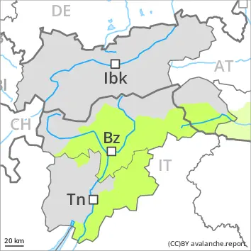
2400m
Avalanche Problem
Persistent weak layer
2400m
Gliding snow
2400m
Weakly bonded old snow and gliding snow represent the main danger.
Dry avalanches can in some places be released by a single winter sport participant and reach medium size. This applies in particular on very steep west, north and east facing slopes above approximately 2400 m.
More frequent gliding avalanches are possible, even medium-sized ones. Caution is to be exercised in particular on steep grassy slopes below approximately 2400 m.
As a consequence of warming during the day and solar radiation more mostly small wet loose snow avalanches are possible, in particular on extremely steep sunny slopes.
Snowpack
dp.1: deep persistent weak layer dp.2: gliding snow
Below approximately 2600 m: Towards its surface, the snowpack is moist. Below approximately 2000 m: The snowpack is wet all the way through.
Faceted weak layers exist in the bottom section of the old snowpack. This applies especially on west, north and east facing slopes at elevated altitudes, especially in shady places that are protected from the wind.
The somewhat older wind slabs are lying on surface hoar in some places on shady slopes at elevated altitudes. This applies especially in the west.
Tendency
Further decrease in avalanche danger. Weakly bonded old snow represents the main danger.
Danger level
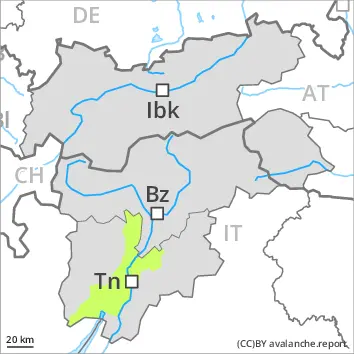
2400m
Avalanche Problem
Persistent weak layer
2400m
Wet snow
2600m
Weakly bonded old snow and wet snow require caution.
In some places avalanches can be triggered in the weakly bonded old snow. Such avalanche prone locations are to be found in particular on very steep west, north and east facing slopes above approximately 2400 m and in gullies and bowls, and behind abrupt changes in the terrain. Mostly avalanches are small. Apart from the danger of being buried, restraint should be exercised as well in view of the danger of avalanches sweeping people along and giving rise to falls.
As a consequence of warming during the day and solar radiation small wet loose snow avalanches are to be expected below approximately 2600 m, in particular on extremely steep sunny slopes.
In addition further small to medium-sized gliding avalanches are possible. Caution is to be exercised in particular on steep grassy slopes.
Snowpack
dp.1: deep persistent weak layer dp.10: springtime scenario
Below approximately 2600 m: Steep sunny slopes: The high temperatures will give rise to increasing moistening of the snowpack.
Avalanche prone weak layers exist deeper in the old snowpack in particular on steep shady slopes.
The snowpack will be subject to considerable local variations. From a snow sport perspective, in most cases insufficient snow is lying.
Tendency
Decrease in avalanche danger. The weather will be mild.
Danger level
2400m
Avalanche Problem
Wind slab
2400m
Persistent weak layer
2400m
Wind slabs represent the main danger.
The wind slabs must be evaluated with care and prudence especially on very steep west, north and east facing slopes. The avalanche prone locations are to be found in particular in gullies and bowls, and behind abrupt changes in the terrain above approximately 2400 m. Avalanches can in isolated cases reach medium size. Apart from the danger of being buried, restraint should be exercised as well in view of the danger of avalanches sweeping people along and giving rise to falls. Avalanches can additionally in very isolated cases be released in near-ground layers on very steep shady slopes.
Snowpack
dp.1: deep persistent weak layer dp.6: cold, loose snow and wind
The snowpack will be subject to considerable local variations. The wind slabs are lying on top of a weakly bonded old snowpack on west, north and east facing slopes at elevated altitudes. Faceted weak layers exist in the bottom section of the old snowpack in shady places that are protected from the wind. Steep sunny slopes: The solar radiation will give rise as the day progresses to increasing moistening of the snowpack.
Tendency
Tuesday: The avalanche danger will persist. Until Friday the weather will be very mild.
Danger level
Avalanche Problem
Gliding snow
Wet snow
Wet and gliding snow require caution. Thus far only a little snow is lying.
As a consequence of warming during the day and solar radiation more mostly small wet loose snow avalanches are possible, in particular on extremely steep sunny slopes.
In addition further mostly small gliding avalanches are possible. Caution is to be exercised in particular on steep grassy slopes.
Snowpack
dp.2: gliding snow dp.10: springtime scenario
The snowpack will be in most cases wet all the way through. Only a little snow is now lying.
Tendency
Further decrease in avalanche danger.
Danger level
Moist avalanches can be released by people, but they will be small in most cases.
As a consequence of warming, the likelihood of moist snow slides during the day being released will increase a little, in particular on extremely steep sunny slopes, and at the base of rock walls. Avalanches can additionally in very isolated cases be released on extremely steep shady slopes. This applies in particular in gullies and bowls at elevated altitudes. Avalanches are small.
Apart from the danger of being buried, restraint should be exercised in particular in view of the danger of avalanches sweeping people along and giving rise to falls.
Snowpack
Steep sunny slopes: The high temperatures will give rise to rapid moistening of the snowpack.
Steep shady slopes: In isolated cases various wind slab layers are lying on a weakly bonded old snowpack.
The snowpack will be subject to considerable local variations. From a snow sport perspective, in most cases insufficient snow is lying.
Tendency
The weather will be warm. A little snow is lying.
Danger level
Wind slabs represent the main danger.
The wind slabs can be released in isolated cases in particular on very steep shady slopes. Individual avalanche prone locations are to be found in gullies and bowls, and behind abrupt changes in the terrain. Apart from the danger of being buried, restraint should be exercised as well in view of the danger of avalanches sweeping people along and giving rise to falls.
Snowpack
Wind slabs are lying on top of a weakly bonded old snowpack especially on steep shady slopes. The snowpack will be subject to considerable local variations. In addition, from a snow sport perspective, insufficient snow is lying. Especially sunny slopes: The solar radiation will give rise to rapid moistening of the snowpack.
Tendency
Tuesday: The avalanche danger will persist. Until Friday the weather will be very mild.