As a consequence of new snow and a strong wind from easterly directions, wind slabs will form from the middle of the day in gullies and bowls and behind abrupt changes in the terrain. These can in some cases be released, even by a single winter sport participant, but they will be small in most cases. Caution is to be exercised in particular on shady slopes above the tree line in the regions exposed to heavier precipitation. As a consequence of the wind the wind slabs will increase in size in the afternoon.
Snowpack
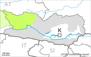
dp.6: cold, loose snow and wind
In particular along the border with Italy 5 to 10 cm of snow will fall. The wind will be strong for a temporary period in some regions. The fresh wind slabs will be deposited on the unfavourable surface of an old snowpack on wind-protected shady slopes. The old snowpack will be subject to considerable local variations.
Tendency
The conditions will foster a rapid stabilisation of the snowpack.
Danger level
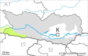
2600m
Avalanche Problem
Persistent weak layer
2600m
Slight increase in avalanche danger as a consequence of the new snow.
As a consequence of new snow and a gusty wind, sometimes avalanche prone wind slabs will form in particular on northwest, north and northeast facing slopes. Caution is to be exercised adjacent to ridgelines and in gullies and bowls at elevated altitudes.
In isolated cases avalanches can be triggered in the weakly bonded old snow. Such avalanche prone locations are to be found in particular on extremely steep shady slopes above approximately 2600 m. Mostly avalanches are small.
Apart from the danger of being buried, restraint should be exercised in particular in view of the danger of avalanches sweeping people along and giving rise to falls.
Snowpack
dp.1: deep persistent weak layer
2 to 5 cm of snow will fall.
Shady slopes above approximately 2600 m: Faceted weak layers exist in the bottom section of the snowpack.
Below approximately 2600 m: The snowpack is largely stable. Hardly any snow is lying on south facing slopes.
The snowpack will be generally subject to considerable local variations. Less snow than usual is lying in all altitude zones.
Tendency
Low avalanche danger will prevail.
EARLIER Danger level
LATER Danger level
treeline
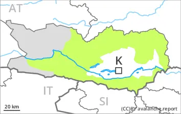
Avalanche Problem
Wind slab
Treeline
Fresh wind slabs require caution.
As a consequence of new snow and a gusty wind from easterly directions, sometimes avalanche prone wind slabs will form from the middle of the day in gullies and bowls and behind abrupt changes in the terrain. These can be released, even by a single winter sport participant, but they will be small in most cases. Caution is to be exercised in particular on northwest, north and northeast facing slopes above the tree line in the regions exposed to heavier precipitation. As a consequence of the wind the wind slabs will increase in size in the afternoon. In addition individual small loose snow avalanches are possible.
Snowpack
dp.6: cold, loose snow and wind dp.1: deep persistent weak layer
In some regions 10 to 20 cm of snow, and even more in some localities, will fall. The wind will be strong at times in particular from the Koralpe West via the Packalpe to the Saualpe South. The fresh wind slabs will be deposited on the unfavourable surface of an old snowpack on wind-protected northwest, north and northeast facing slopes. The old snowpack will be subject to considerable local variations.
Tendency
As a consequence of the snowfall, the likelihood of small avalanches being released will increase a little.