In isolated cases avalanches can be triggered in the weakly bonded old snow. Such avalanche prone locations are to be found in particular on extremely steep shady slopes above approximately 2600 m.
As a consequence of new snow and a strong wind from easterly directions, wind slabs will form from the middle of the day in gullies and bowls and behind abrupt changes in the terrain. These can in some cases be released, even by a single winter sport participant, but they will be small in most cases. Caution is to be exercised in particular on shady slopes above the tree line in the regions exposed to heavier precipitation. Avalanches can in isolated cases penetrate deep layers and reach medium size, especially at elevated altitudes.
Snowpack
dp.6: cold, loose snow and wind dp.1: deep persistent weak layer
In some regions up to 15 cm of snow will fall. The wind will be strong for a temporary period in some regions. The fresh wind slabs will be deposited on the unfavourable surface of an old snowpack on wind-protected shady slopes. The old snowpack will be subject to considerable local variations.
Tendency
The conditions will foster a gradual stabilisation of the snow drift accumulations.
EARLIER Danger level
LATER Danger level
treeline
Avalanche Problem
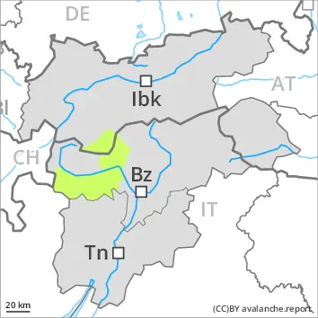
Wind slab
Treeline
Fresh wind slabs represent the main danger.
As a consequence of new snow and a strong wind from easterly directions, wind slabs will form from the middle of the day in gullies and bowls and behind abrupt changes in the terrain. These can in some cases be released, even by a single winter sport participant, but they will be small in most cases. Caution is to be exercised in particular on shady slopes above the tree line in the regions exposed to heavier precipitation. As a consequence of the wind the wind slabs will increase in size in the afternoon.
Snowpack
dp.6: cold, loose snow and wind
In particular along the border with Italy 5 to 10 cm of snow will fall. The wind will be strong for a temporary period in some regions. The fresh wind slabs will be deposited on the unfavourable surface of an old snowpack on wind-protected shady slopes. The old snowpack will be subject to considerable local variations.
Tendency
The conditions will foster a rapid stabilisation of the snowpack.
EARLIER Danger level
2400m
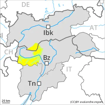
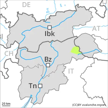
Avalanche Problem
Persistent weak layer
2400m
LATER Danger level
treeline
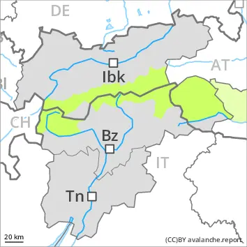
Avalanche Problem
Wind slab
Treeline
Persistent weak layer
2400m
As the day progresses as a consequence of new snow and wind there will be only a slight increase in the avalanche danger.
The avalanche danger will increase during the day, reaching danger level 2 (moderate). Especially in the regions with a lot of snow avalanches can be triggered in the weakly bonded old snow. This applies especially on steep shady slopes above the tree line. Avalanches can in isolated cases reach medium size. Mostly the avalanches are otherwise small. As a consequence of new snow and a moderate to strong wind from easterly directions, sometimes avalanche prone wind slabs will form in particular adjacent to ridgelines and in gullies and bowls. Apart from the danger of being buried, restraint should be exercised as well in view of the danger of avalanches sweeping people along and giving rise to falls.
Snowpack
Over a wide area up to 20 cm of snow, and even more in some localities, will fall above approximately 1200 m. The new snow will be deposited on the unfavourable surface of an old snowpack. Shady slopes above approximately 2400 m: Faceted weak layers exist in the bottom section of the snowpack.
Below approximately 2400 m: The snowpack is largely stable. Hardly any snow is lying on south facing slopes.
The snowpack will be generally subject to considerable local variations. Only a small amount of snow is lying for the time of year in all altitude zones.
Tendency
The conditions will foster a gradual stabilisation of the snow drift accumulations.
EARLIER Danger level
LATER Danger level
treeline
Avalanche Problem
Wind slab
Treeline
As a consequence of new snow and wind a moderate avalanche danger will be encountered in some regions.
Avalanches can in isolated cases be released. The avalanche prone locations are to be found in particular on very steep shady slopes at elevated altitudes. As a consequence of new snow and a sometimes strong wind from easterly directions, sometimes avalanche prone wind slabs will form in particular adjacent to ridgelines and in gullies and bowls. Apart from the danger of being buried, restraint should be exercised in particular in view of the danger of avalanches sweeping people along and giving rise to falls.
Snowpack
Above approximately 1000 m snow will fall in particular in the Prealps. In some cases new snow and wind slabs are lying on soft layers. The fresh wind slabs are in isolated cases prone to triggering.
Only a small amount of snow is lying for the time of year.
Tendency
The conditions will foster a gradual stabilisation of the snow drift accumulations.
Danger level
Individual avalanche prone locations are to be found on shady slopes at elevated altitudes.
As a consequence of new snow and a gusty wind, sometimes avalanche prone wind slabs will form in isolated cases. Caution is to be exercised adjacent to ridgelines and in gullies and bowls at elevated altitudes.
In isolated cases avalanches can be triggered in the weakly bonded old snow. Such avalanche prone locations are to be found in particular on extremely steep shady slopes above approximately 2600 m. Mostly avalanches are small.
Apart from the danger of being buried, restraint should be exercised as well in view of the danger of avalanches sweeping people along and giving rise to falls.
Snowpack
Some snow will fall. Shady slopes above approximately 2600 m: Faceted weak layers exist in the bottom section of the snowpack.
Below approximately 2600 m: The snowpack is largely stable. Hardly any snow is lying on south facing slopes.
The snowpack will be generally subject to considerable local variations. Less snow than usual is lying in all altitude zones.
Tendency
Low avalanche danger will prevail.
Danger level
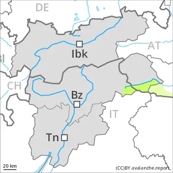
2600m
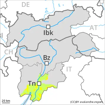
Avalanche Problem
Persistent weak layer
2600m
Slight increase in avalanche danger as a consequence of the new snow.
As a consequence of new snow and a gusty wind, sometimes avalanche prone wind slabs will form in particular on northwest, north and northeast facing slopes. Caution is to be exercised adjacent to ridgelines and in gullies and bowls at elevated altitudes.
In isolated cases avalanches can be triggered in the weakly bonded old snow. Such avalanche prone locations are to be found in particular on extremely steep shady slopes above approximately 2600 m. Mostly avalanches are small.
Apart from the danger of being buried, restraint should be exercised in particular in view of the danger of avalanches sweeping people along and giving rise to falls.
Snowpack
dp.1: deep persistent weak layer
2 to 5 cm of snow will fall.
Shady slopes above approximately 2600 m: Faceted weak layers exist in the bottom section of the snowpack.
Below approximately 2600 m: The snowpack is largely stable. Hardly any snow is lying on south facing slopes.
The snowpack will be generally subject to considerable local variations. Less snow than usual is lying in all altitude zones.
Tendency
Low avalanche danger will prevail.
Danger level
treeline
Avalanche Problem
Wind slab
Treeline
Low avalanche danger will prevail.
Avalanches can in isolated cases be released. The avalanche prone locations are to be found in particular on very steep shady slopes at elevated altitudes. Avalanches are small.
Apart from the danger of being buried, restraint should be exercised in particular in view of the danger of avalanches sweeping people along and giving rise to falls.
Snowpack
Some snow will fall. In some cases new snow and wind slabs are lying on soft layers. The fresh wind slabs are in isolated cases prone to triggering.
Only a little snow is lying.
Tendency
Low avalanche danger will prevail.
Danger level
Low avalanche danger will prevail.
Avalanches can scarcely be released. Very isolated avalanche prone locations are to be found on very steep shady slopes at elevated altitudes.
Apart from the danger of being buried, restraint should be exercised in particular in view of the danger of avalanches sweeping people along and giving rise to falls.
Snowpack
Little snow will fall.
Faceted weak layers exist in the bottom section of the snowpack on shady slopes, in particular above approximately 2600 m.
The snowpack will be subject to considerable local variations. Less snow than usual is lying in all altitude zones.
Tendency
Low avalanche danger will prevail.
Danger level
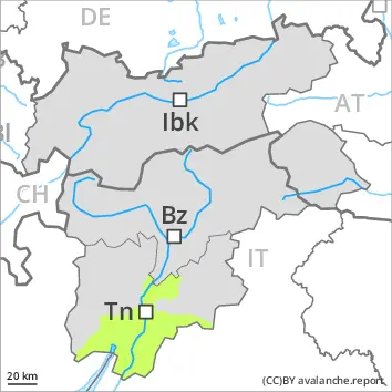
2600m
Avalanche Problem
Persistent weak layer
2600m
Individual avalanche prone locations are to be found on shady slopes at elevated altitudes.
In isolated cases avalanches can be triggered in the weakly bonded old snow. Such avalanche prone locations are to be found in particular on extremely steep shady slopes above approximately 2600 m. Mostly avalanches are small.
As a consequence of a sometimes strong wind from southerly directions, small wind slabs formed in particular adjacent to ridgelines on west, north and east facing slopes. Caution is to be exercised adjacent to ridgelines and in gullies and bowls at elevated altitudes.
Apart from the danger of being buried, restraint should be exercised in particular in view of the danger of avalanches sweeping people along and giving rise to falls.
Snowpack
Shady slopes above approximately 2600 m: Faceted weak layers exist in the bottom section of the snowpack.
Below approximately 2600 m: The snowpack is largely stable. Hardly any snow is lying on south facing slopes.
The snowpack will be generally subject to considerable local variations. Less snow than usual is lying in all altitude zones.