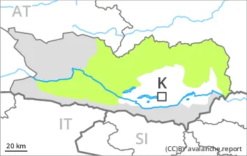
Increase in avalanche danger as a consequence of the new snow.
From midday as the snowfall becomes more intense there will be an appreciable increase in the avalanche danger to level 3 (considerable). The fresh snow as well as the wind slabs that are forming during the snowfall will be deposited on a weakly bonded old snowpack in particular on west, north and east facing slopes above approximately 2000 m. Especially here avalanches can be triggered in the faceted old snow and reach medium size. Caution is to be exercised in particular in gullies and bowls, and behind abrupt changes in the terrain, as well as in places that are protected from the wind. The avalanche prone locations are barely recognisable. The number and size of avalanche prone locations will increase with altitude. Individual natural avalanches are not ruled out.
Snowpack
dp.6: cold, loose snow and wind
Up to 5 cm of snow has fallen since Saturday. 10 to 20 cm of snow, and even more in some localities, will fall above approximately 1500 m. As a consequence of a gusty wind from southerly directions, soft wind slabs will form. These will be deposited on a weakly bonded old snowpack above approximately 2000 m. The old snowpack is faceted and weak; its surface consists of faceted crystals. This applies especially in shady places that are protected from the wind. The old snowpack will be subject to considerable local variations.
Tendency
The new snow and wind slabs remain prone to triggering.
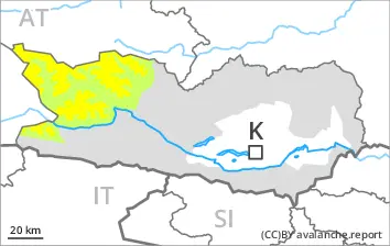
EARLIER Danger level
treeline
Avalanche Problem
Persistent weak layer
Treeline
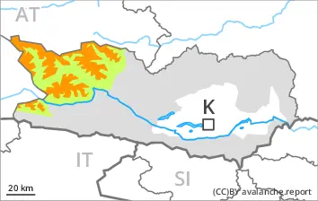
LATER Danger level
treeline
Avalanche Problem
Persistent weak layer
Treeline
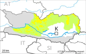
Increase in avalanche danger as a consequence of the new snow.
From midday as the snowfall becomes more intense there will be an appreciable increase in the avalanche danger to level 3 (considerable). The fresh snow as well as the wind slabs that are forming during the snowfall will be deposited on a weakly bonded old snowpack in particular on west, north and east facing slopes above the tree line. Especially here avalanches can be triggered in the faceted old snow and reach medium size. With the onset of the intense snowfall, the natural avalanche activity will increase. Especially in places where the wind is stronger the avalanche danger is greater. The number and size of avalanche prone locations will increase with altitude.
Snowpack
dp.5: snowfall after a long period of cold dp.6: cold, loose snow and wind
Up to 10 cm of snow has fallen since Saturday. 15 to 30 cm of snow, and even more in some localities, will fall above approximately 1500 m. As a consequence of a gusty wind from southerly directions, soft wind slabs will form. These will be deposited on a weakly bonded old snowpack above the tree line. The old snowpack is faceted and weak; its surface consists of faceted crystals. This applies especially in shady places that are protected from the wind. The old snowpack will be subject to considerable local variations.
Tendency
The new snow and wind slabs remain prone to triggering.
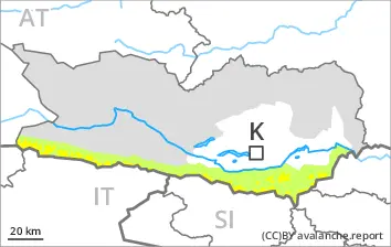
EARLIER Danger level
treeline
Avalanche Problem
Persistent weak layer
Treeline
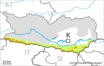
LATER Danger level
treeline
Avalanche Problem
Persistent weak layer
Treeline
Increase in avalanche danger in the course of the day. Wind slabs are to be avoided.
From midday as the snowfall becomes more intense there will be an increase in the avalanche danger to level 2 (moderate). The fresh snow as well as the wind slabs that are forming during the snowfall will be deposited on a weakly bonded old snowpack in particular on west, north and east facing slopes above the tree line. Especially here avalanches can be triggered in the faceted old snow. This applies even in case of a single winter sport participant. In isolated cases avalanches are medium-sized. Caution is to be exercised in particular in gullies and bowls, and behind abrupt changes in the terrain, as well as in places that are protected from the wind. The avalanche prone locations are barely recognisable.
Snowpack
dp.5: snowfall after a long period of cold dp.6: cold, loose snow and wind
5 to 15 cm of snow, and even more in some localities, will fall above approximately 1500 m. As a consequence of a gusty wind from southerly directions, soft wind slabs will form. These will be deposited on a weakly bonded old snowpack above the tree line. The old snowpack is faceted and weak. This applies especially in shady places that are protected from the wind. The old snowpack will be subject to considerable local variations.
Tendency
The new snow and wind slabs remain prone to triggering.