Increase in avalanche danger as a consequence of the new snow.
From midday as the snowfall becomes more intense there will be an increase in the avalanche danger to level 3 (considerable). The fresh snow as well as the wind slabs that are forming during the snowfall will be deposited on a weakly bonded old snowpack in particular on west, north and east facing slopes above approximately 2000 m. Especially here avalanches can be triggered in the faceted old snow and reach medium size. Caution is to be exercised in particular in gullies and bowls, and behind abrupt changes in the terrain, as well as in places that are protected from the wind. The avalanche prone locations are barely recognisable. The number and size of avalanche prone locations will increase with altitude. Individual natural avalanches are not ruled out.
Snowpack
dp.6: cold, loose snow and wind
Up to 5 cm of snow has fallen since Saturday. 10 to 20 cm of snow, and even more in some localities, will fall above approximately 1500 m. As a consequence of a gusty wind from southerly directions, soft wind slabs will form. These will be deposited on a weakly bonded old snowpack above approximately 2000 m. The old snowpack is faceted and weak; its surface consists of faceted crystals. This applies especially in shady places that are protected from the wind. The old snowpack will be subject to considerable local variations.
Tendency
The new snow and wind slabs remain prone to triggering.
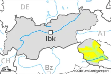
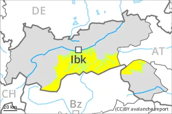
EARLIER Danger level
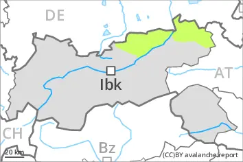
treeline
Avalanche Problem
Persistent weak layer
Treeline
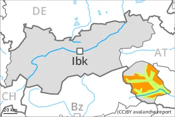
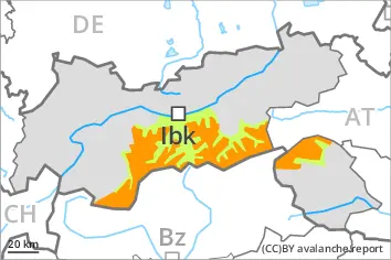
LATER Danger level
treeline
Avalanche Problem
Persistent weak layer
Treeline
Increase in avalanche danger as a consequence of the new snow.
From midday as the snowfall becomes more intense there will be an appreciable increase in the avalanche danger to level 3 (considerable). The fresh snow as well as the wind slabs that are forming during the snowfall will be deposited on a weakly bonded old snowpack in particular on west, north and east facing slopes above the tree line. Especially here avalanches can be triggered in the faceted old snow and reach medium size. With the onset of the intense snowfall, the natural avalanche activity will increase. Especially in places where the wind is stronger the avalanche danger is greater. The number and size of avalanche prone locations will increase with altitude.
Snowpack
dp.5: snowfall after a long period of cold dp.6: cold, loose snow and wind
Up to 10 cm of snow has fallen since Saturday. 15 to 30 cm of snow, and even more in some localities, will fall above approximately 1500 m. As a consequence of a gusty wind from southerly directions, soft wind slabs will form. These will be deposited on a weakly bonded old snowpack above the tree line. The old snowpack is faceted and weak; its surface consists of faceted crystals. This applies especially in shady places that are protected from the wind. The old snowpack will be subject to considerable local variations.
Tendency
The new snow and wind slabs remain prone to triggering.
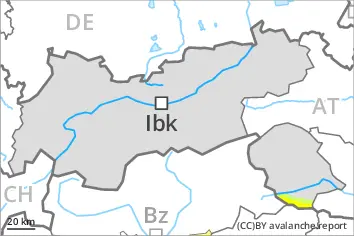
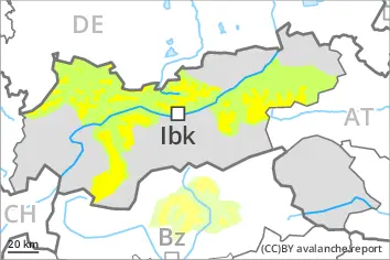
EARLIER Danger level
2200m
Avalanche Problem
Persistent weak layer
2200m
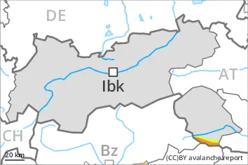
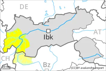
LATER Danger level
2000m
Avalanche Problem
Persistent weak layer
2000m
Increase in avalanche danger as a consequence of the new snow.
From midday as the snowfall becomes more intense there will be an appreciable increase in the avalanche danger to level 3 (considerable). The fresh snow as well as the wind slabs that are forming during the snowfall will be deposited on a weakly bonded old snowpack in particular on west, north and east facing slopes above approximately 2000 m. Especially here avalanches can be triggered in the faceted old snow and reach medium size. Caution is to be exercised in particular in gullies and bowls, and behind abrupt changes in the terrain, as well as in places that are protected from the wind. The avalanche prone locations are barely recognisable. The number and size of avalanche prone locations will increase with altitude. Individual natural avalanches are not ruled out.
Snowpack
dp.6: cold, loose snow and wind
Up to 5 cm of snow has fallen since Saturday. 10 to 20 cm of snow, and up to 30 cm in some localities, will fall above approximately 1500 m. As a consequence of a gusty wind from southerly directions, soft wind slabs will form. These will be deposited on a weakly bonded old snowpack above approximately 2000 m. The old snowpack is faceted and weak; its surface consists of faceted crystals. This applies especially in shady places that are protected from the wind. The old snowpack will be subject to considerable local variations.
Tendency
The new snow and wind slabs remain prone to triggering.
Danger level
2200m
Avalanche Problem
Persistent weak layer
2200m
Weakly bonded old snow represents the main danger.
Fresh and older wind slabs are prone to triggering. These can be released in the weakly bonded old snow, even by a single winter sport participant. Avalanches can reach medium size. The avalanche prone locations are to be found in particular on west to north to east facing aspects above approximately 2200 m. Individual avalanche prone locations are to be found also on steep south facing slopes above approximately 2600 m. Caution is to be exercised in particular in gullies and bowls, and behind abrupt changes in the terrain, as well as on wind-loaded slopes. The avalanche prone locations are barely recognisable.
Reports filed by observers and stability tests confirm a sometimes treacherous avalanche situation.
Apart from the danger of being buried, restraint should be exercised as well in view of the danger of avalanches sweeping people along and giving rise to falls.
Snowpack
dp.5: snowfall after a long period of cold dp.6: cold, loose snow and wind
Some snow will fall, especially in the south. As a consequence of new snow and a moderate southerly wind, mostly small wind slabs will form. The fresh and older wind slabs are lying on top of a weakly bonded old snowpack. They are bonding only slowly with the old snowpack. Distinct weak layers exist in the old snowpack. The old snowpack consists of faceted crystals.
The snowpack will be generally subject to considerable local variations. Steep sunny slopes: As a consequence of solar radiation a crust formed on the surface during the last few days. Only a small amount of snow is lying for the time of year in all altitude zones.
Tendency
Some snow will fall. Slight increase in avalanche danger. The fresh and older wind slabs can be released by a single winter sport participant.
Danger level
2000m
Avalanche Problem
Persistent weak layer
2000m
Weakly bonded old snow is to be evaluated with care and prudence.
The fresh and somewhat older wind slabs are lying on top of a weakly bonded old snowpack. Especially here avalanches can be triggered in the weakly bonded old snow, this applies even in case of a single winter sport participant. Mostly they are medium-sized.
Caution is to be exercised in particular in gullies and bowls, and behind abrupt changes in the terrain, as well as on wind-loaded slopes. The avalanche prone locations are to be found in particular on very steep west, north and southeast facing slopes above approximately 2000 m and on south facing slopes above approximately 2600 m. These places are barely recognisable, even to the trained eye.
Reports filed by observers and stability tests confirm a sometimes treacherous avalanche situation. Experience and restraint are advisable.
Snowpack
dp.5: snowfall after a long period of cold
Some snow will fall in some regions. Distinct weak layers exist in the old snowpack. This applies in particular on west, north and southeast facing slopes above approximately 2000 m, as well as on south facing slopes above approximately 2600 m. Older wind slabs are bonding only slowly with the old snowpack. The old snowpack is faceted.
Steep sunny slopes: As a consequence of solar radiation a crust formed on the surface during the last few days.
Tendency
Avalanches can as before be released by a single winter sport participant and reach medium size.
Danger level
2200m
Avalanche Problem
Wind slab
2200m
Wind slabs require caution.
The somewhat older wind slabs can be released by a single winter sport participant in some cases. The avalanche prone locations are to be found in particular on west to north to east facing aspects above approximately 2200 m. Caution is to be exercised in particular in gullies and bowls, as well as adjacent to ridgelines. Such avalanche prone locations are easy to recognise. Mostly the avalanches are small.
Apart from the danger of being buried, restraint should be exercised as well in view of the danger of avalanches sweeping people along and giving rise to falls.
Snowpack
The old snowpack consists of faceted crystals. The mostly small wind slabs of the last few days are lying on top of a weakly bonded old snowpack in particular on shady slopes.
The snowpack will be generally subject to considerable local variations. Only a small amount of snow is lying for the time of year in all altitude zones.