Afternoon: Increase in avalanche danger. Wind slabs and weakly bonded old snow represent the main danger.
The fresh snow and the wind slabs that are forming during the snowfall will be deposited on a weakly bonded old snowpack on west, north and east facing slopes above approximately 2000 m. Especially here avalanches can be triggered in the faceted old snow. This applies even in case of a small load. Mostly avalanches are medium-sized. Remotely triggered avalanches are possible in isolated cases.
The avalanche prone locations are covered with new snow and are barely recognisable. Whumpfing sounds and the formation of shooting cracks when stepping on the snowpack serve as an alarm indicating the danger.
Snowpack
dp.5: snowfall after a long period of cold dp.6: cold, loose snow and wind
Up to 20 cm of snow has fallen since Saturday. In some regions 15 cm of snow, and even more in some localities, will fall.
As a consequence of a moderate wind from southerly directions, further wind slabs will form. These are lying on top of a weakly bonded old snowpack in particular on shady slopes above approximately 2000 m.
The old snowpack is faceted and weak. This applies especially in shady places that are protected from the wind. The old snowpack will be subject to considerable local variations.
Tendency
The current avalanche situation calls for caution and restraint. The new snow and wind slabs remain prone to triggering.
Danger level
treeline
Avalanche Problem
Persistent weak layer
Treeline
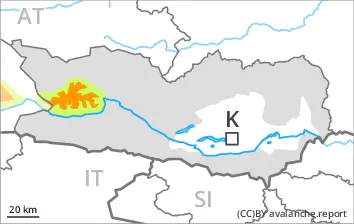
Afternoon: The avalanche danger is within the uppermost range of danger level 3 (considerable). A precarious avalanche situation will prevail.
As the day progresses as a consequence of new snow and wind there will be an increase in the avalanche danger.
The fresh snow and the wind slabs that are forming during the snowfall will be deposited on a weakly bonded old snowpack on west, north and east facing slopes above the tree line. This also applies in isolated cases on south facing slopes at elevated altitudes. Especially here avalanches can be triggered in the faceted old snow. This applies even in case of a small load. Mostly avalanches are medium-sized. Remotely triggered avalanches are possible. With the onset of the snowfall, the natural avalanche activity will increase.
The avalanche prone locations are widespread and are barely recognisable. The number and size of avalanche prone locations will increase with altitude. Individual avalanche prone locations are to be found also in areas close to the tree line. Natural avalanches and whumpfing sounds and the formation of shooting cracks when stepping on the snowpack serve as an alarm indicating the danger.
The current avalanche situation calls for caution and restraint.
Snowpack
dp.5: snowfall after a long period of cold dp.6: cold, loose snow and wind
Up to 40 cm of snow has fallen since Saturday. 25 cm of snow, and even more in some localities, will fall.
As a consequence of a gusty wind from southerly directions, further wind slabs will form. These are lying on top of a weakly bonded old snowpack above the tree line.
The old snowpack is faceted and weak. This applies especially in shady places that are protected from the wind. The old snowpack will be subject to considerable local variations.
Tendency
Further increase in avalanche danger as a consequence of new snow and wind.
Danger level
treeline
Avalanche Problem
Persistent weak layer
Treeline
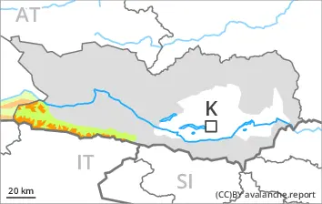
Afternoon: Increase in avalanche danger. A precarious avalanche situation will prevail.
The fresh snow and the wind slabs that are forming during the snowfall will be deposited on a weakly bonded old snowpack on west, north and east facing slopes above the tree line. Especially here avalanches can be triggered in the faceted old snow. This applies even in case of a small load. Mostly avalanches are medium-sized. Remotely triggered avalanches are possible.
The avalanche prone locations are widespread and are barely recognisable. The number and size of avalanche prone locations will increase with altitude. Whumpfing sounds and the formation of shooting cracks when stepping on the snowpack serve as an alarm indicating the danger.
The current avalanche situation calls for caution and restraint.
Snowpack
dp.5: snowfall after a long period of cold dp.6: cold, loose snow and wind
30 cm of snow has fallen since Saturday. In some regions 15 cm of snow, and even more in some localities, will fall above approximately 1500 m.
As a consequence of a gusty wind from southerly directions, further wind slabs will form. These are lying on top of a weakly bonded old snowpack above the tree line.
The old snowpack is faceted and weak. This applies especially in shady places that are protected from the wind. The old snowpack will be subject to considerable local variations.
Tendency
The current avalanche situation calls for caution and restraint. The new snow and wind slabs remain prone to triggering.
Danger level
treeline
Avalanche Problem
Persistent weak layer
Treeline
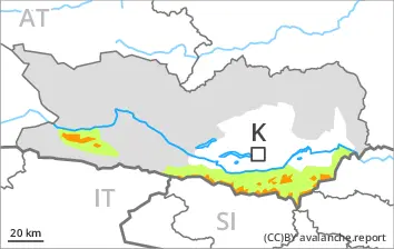
Wind slabs and weakly bonded old snow represent the main danger.
The small quantity of fresh snow and in particular the wind slabs formed during the snowfall are lying on top of a weakly bonded old snowpack on west, north and east facing slopes above the tree line. Especially here avalanches can be triggered in the faceted old snow. This applies even in case of a single winter sport participant. In isolated cases avalanches are medium-sized. Caution is to be exercised in particular in gullies and bowls. The avalanche prone locations are sometimes covered with new snow.
As a consequence of warming during the day and solar radiation loose snow avalanches are possible.
Snowpack
dp.5: snowfall after a long period of cold dp.6: cold, loose snow and wind
5 to 15 cm of snow has fallen since Saturday above approximately 1500 m. In some regions 10 cm of snow will fall.
As a consequence of a gusty wind from southerly directions, further wind slabs will form. These are lying on top of a weakly bonded old snowpack above the tree line.
The old snowpack is faceted and weak. This applies especially in shady places that are protected from the wind. The old snowpack will be subject to considerable local variations.
Tendency
The new snow and wind slabs remain prone to triggering. In some regions increase in avalanche danger as a consequence of new snow and wind.
Danger level
2200m
Avalanche Problem
Persistent weak layer
2200m
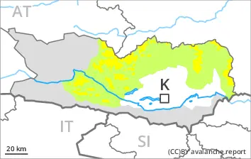
Wind slabs and weakly bonded old snow are to be assessed with care and prudence.
The fresh snow and the wind slabs formed during the snowfall are lying on top of a weakly bonded old snowpack on west, north and east facing slopes above approximately 2200 m. Especially here avalanches can be triggered in the faceted old snow. This applies even in case of a small load. Mostly avalanches are medium-sized. The avalanche prone locations are covered with new snow and are barely recognisable.
Snowpack
dp.5: snowfall after a long period of cold dp.6: cold, loose snow and wind
Some snow will fall. As a consequence of new snow and a moderate southerly wind, further wind slabs will form. The fresh and older wind slabs are lying on top of a weakly bonded old snowpack. They are bonding only slowly with the old snowpack. Distinct weak layers exist in the old snowpack. The old snowpack consists of faceted crystals.
The snowpack will be generally subject to considerable local variations.
Tendency
The fresh and older wind slabs can be released by a single winter sport participant.