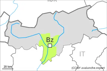
Danger level
 | 1800m |
|  |
|  | ||||
| |
|  |


![]()
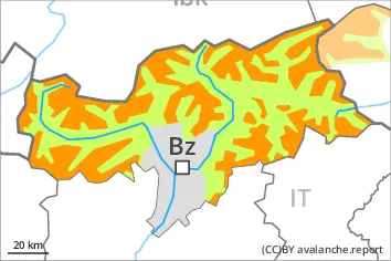
Outside marked and open pistes a precarious avalanche situation will prevail.
As a consequence of snowfall and the strong to storm force southwesterly wind, the snow drift accumulations have increased in size on Wednesday. The wind slabs are covered with new snow and therefore difficult to recognise. In particular on steep west, north and east facing slopes avalanches can be triggered in the weakly bonded old snow and reach medium size. This applies even in case of a single winter sport participant.
Caution is to be exercised in particular in gullies and bowls, and behind abrupt changes in the terrain, as well as in places that are protected from the wind. The number and size of avalanche prone locations will increase with altitude.
Whumpfing sounds and the formation of shooting cracks when stepping on the snowpack serve as an alarm indicating the danger. Remotely triggered avalanches are possible in isolated cases. Restraint is advisable.
Snowpack
dp.6: cold, loose snow and wind
dp.5: snowfall after a long period of cold
Up to 20 cm of snow, and even more in some localities, has fallen. This applies in particular in the south. The new snow and wind slabs are lying on surface hoar in some places in particular on shady slopes above approximately 1800 m. As a consequence of a strong to storm force wind from southerly directions, sometimes large wind slabs formed. These are lying on top of a weakly bonded old snowpack above approximately 1800 m. The old snowpack is faceted and weak. This applies especially in shady places that are protected from the wind.
Tendency
Hardly any decrease in avalanche danger. The current avalanche situation calls for caution and restraint.