Outside marked and open pistes a very dangerous avalanche situation will prevail. The danger exists in particular in alpine snow sports terrain.
The fresh snow and the wind slabs that are being formed by the strong westerly wind can be released easily or naturally in all aspects above the tree line. The avalanche prone locations are to be found also in areas close to the tree line. Remotely triggered avalanches are possible.
Avalanches can in some cases penetrate deep layers and reach large size. This applies on west, north and east facing slopes. Caution is to be exercised in particular in leeward starting zones that have retained the snow thus far.
On very steep slopes small and, in isolated cases, medium-sized loose snow avalanches are possible.
Snowpack
dp.1: deep persistent weak layer dp.6: cold, loose snow and wind
15 to 30 cm of snow has fallen since Sunday. 15 to 20 cm of snow, and even more in some localities, will fall until Wednesday. The wind will be strong to storm force.
The fresh snow and in particular the extensive wind slabs will be deposited on a weakly bonded old snowpack in particular on west, north and east facing slopes above the tree line. In some places various wind slab layers are lying on surface hoar. Faceted weak layers exist in the bottom section of the snowpack.
Tendency
The conditions are very dangerous for backcountry touring and other off-piste activities. As a consequence of the strong westerly wind more natural avalanches are possible.
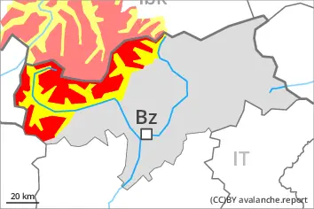
Danger level
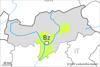
1800m
Avalanche Problem
Persistent weak layer
1800m
Wind slab
2000m
Distinct weak layers in the old snowpack necessitate caution.
Distinct weak layers in the old snowpack can be released even by individual winter sport participants. Mostly avalanches are medium-sized. Caution is to be exercised in particular on steep west, north and east facing slopes above approximately 1800 m. The avalanche prone locations are difficult to recognise. Isolated whumpfing sounds can indicate the danger.
In addition the mostly small wind slabs in particular adjacent to ridgelines and in gullies and bowls are prone to triggering. This applies in particular above approximately 2000 m. They are clearly recognisable to the trained eye.
Snowpack
dp.1: deep persistent weak layer dp.8: surface hoar blanketed with snow
Some snow will fall. As a consequence of a strong wind from northwesterly directions, avalanche prone wind slabs will form especially in gullies and bowls. Somewhat older wind slabs are lying on surface hoar in some places.
Above approximately 1800 m: The snowpack will be prone to triggering. Distinct weak layers exist in the old snowpack. This applies in particular on west, north and east facing slopes.
Tendency
Weak layers in the old snowpack represent the main danger.
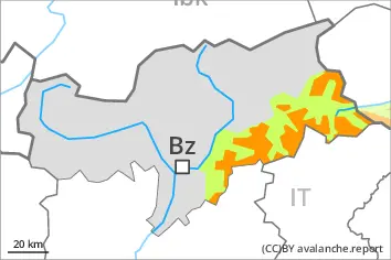
Danger level
treeline
Avalanche Problem
Persistent weak layer
Treeline
Wind slab
Treeline
Individual natural avalanches are to be expected.
The off-piste conditions are dangerous. Wind slabs and weakly bonded old snow require caution.
Distinct weak layers in the old snowpack can be released easily by individual winter sport participants especially in little used terrain. Caution is to be exercised in particular on steep west, north and east facing slopes above the tree line. Individual avalanche prone locations are to be found also in areas close to the tree line. The avalanche prone locations are difficult to recognise. Whumpfing sounds and the formation of shooting cracks when stepping on the snowpack and fresh avalanches serve as an alarm indicating the danger. Remotely triggered avalanches are possible. Mostly avalanches are medium-sized.
As a consequence of new snow and a strong northwesterly wind, easily released wind slabs will form in particular above the tree line, in particular in gullies and bowls, and behind abrupt changes in the terrain. Individual natural avalanches are to be expected.
In the regions neighbouring those that are subject to danger level 4 (high) the avalanche situation is more dangerous. Restraint is advisable.
Snowpack
dp.1: deep persistent weak layer dp.8: surface hoar blanketed with snow
5 to 15 cm of snow, and even more in some localities, has fallen since Sunday. 5 to 15 cm of snow, and even more in some localities, will fall until Wednesday. As a consequence of new snow and strong wind the wind slabs will increase in size additionally. Somewhat older wind slabs are lying on surface hoar in some places. Distinct weak layers exist in the old snowpack. This applies in particular on west, north and east facing slopes above the tree line.
Tendency
The conditions remain unfavourable. Weak layers in the old snowpack represent the main danger. Caution and restraint are recommended.
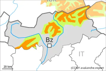
Danger level
treeline
Avalanche Problem
Persistent weak layer
Treeline
Wind slab
Treeline
Wind slabs and weakly bonded old snow require caution.
Avalanches can be released by a single winter sport participant. This applies especially on steep shady slopes adjacent to ridgelines and in gullies and bowls above the tree line. As a consequence of the strong northerly wind, fresh snow drift accumulations will form. These are in some cases prone to triggering. In some cases avalanches are medium-sized.
Backcountry touring calls for caution and restraint. Only a small amount of snow is lying for the time of year.
Snowpack
dp.6: cold, loose snow and wind
Some snow will fall. Faceted weak layers exist in the old snowpack. The fresh and older wind slabs are lying on the unfavourable surface of an old snowpack at elevated altitudes.
Low and intermediate altitudes: The snowpack is moist and its surface has a melt-freeze crust that is barely capable of bearing a load.