The conditions are very dangerous for winter sport activities outside marked and open pistes. Natural avalanches are to be expected in the second half of the day.
Weak layers in the old snowpack can be released very easily. Fresh wind slabs are to be evaluated critically.
The fresh snow and the sometimes large wind slabs that are forming in all aspects can be released very easily above the tree line. Such avalanche prone locations are to be found also in areas close to the tree line. Whumpfing sounds and the formation of shooting cracks when stepping on the snowpack and fresh avalanches serve as an alarm indicating the danger. Remotely triggered avalanches are possible.
The prevalence of the avalanche prone locations will increase from midday. As a consequence of new snow and strong wind more frequent natural avalanches are to be expected. Avalanches can in some cases penetrate deep layers and reach large size, especially on steep west, north and east facing slopes.
On very steep slopes small and, in isolated cases, medium-sized loose snow avalanches are possible, in the event of rain this also applies at low and intermediate altitudes.
Snowpack
dp.1: deep persistent weak layer dp.6: cold, loose snow and wind
Over a wide area 20 to 40 cm of snow, and even more in some localities, has fallen since Sunday. 15 to 30 cm of snow, and even more in some localities, will fall on Thursday. The wind will be strong in some cases. The wind will transport the new snow. Further wind slabs will form.
The snowpack will be prone to triggering over a wide area. The meteorological conditions will bring about a substantial weakening of the snowpack in the afternoon. The new snow and wind slabs are lying on top of a weakly bonded old snowpack. Somewhat older wind slabs are lying on surface hoar. Distinct weak layers exist in the bottom section of the old snowpack. This applies in particular on west, north and east facing slopes above the tree line.
Tendency
The off-piste conditions are very dangerous. Weak layers in the old snowpack represent the main danger.
10 to 20 cm of snow, and even more in some localities, will fall during the night. This applies in particular in the north.
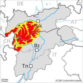
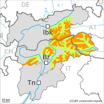
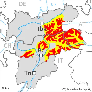
Danger level
treeline
Avalanche Problem
Wind slab
Treeline
Persistent weak layer
Treeline
New snow
Treeline
A lot of snow will fall from early morning in some regions. Backcountry touring and other off-piste activities call for great restraint.
The new snow and wind slabs represent the main danger. Outside marked and open pistes a very precarious avalanche situation will be encountered over a wide area.
In some localities over a wide area 30 to 50 cm of snow, and even more in some localities, will fall. The new snow and wind slabs will be deposited on a weakly bonded old snowpack in particular on steep shady slopes above the tree line. The sometimes storm force wind will transport the new snow, especially at intermediate and high altitudes, as well as in gullies and bowls, and behind abrupt changes in the terrain at elevated altitudes. On very steep slopes natural avalanches must be expected. Mostly the avalanches are medium-sized and easily released. They can be released by small loads. In some places the avalanches can penetrate down to the ground and reach large size. Remotely triggered avalanches are possible. Whumpfing sounds and the formation of shooting cracks when stepping on the snowpack serve as an alarm indicating the danger. The avalanche prone locations are prevalent and are barely recognisable, even to the trained eye. Backcountry touring calls for meticulous route selection.
Snowpack
dp.6: cold, loose snow and wind dp.1: deep persistent weak layer
Over a wide area over a wide area 30 to 50 cm of snow, and even more in some localities, will fall. The sometimes storm force wind will transport the new snow. In all aspects wind slabs will form. The new snow and wind slabs are lying on top of a weakly bonded old snowpack. Distinct weak layers exist in the bottom section of the old snowpack. This applies in particular on west, north and east facing slopes above the tree line. The snowpack remains generally prone to triggering.
Tendency
The snowpack remains unstable over a wide area. The avalanche danger will persist.
Danger level
treeline
Avalanche Problem
Persistent weak layer
Treeline
Wind slab
Treeline
Gliding snow
2400m
Outside marked and open pistes a very dangerous avalanche situation will prevail. Natural avalanches are to be expected in the second half of the day.
Distinct weak layers in the old snowpack represent the main danger. Fresh wind slabs require caution.
Avalanches can be released in deep layers and reach large size. This applies on west, north and east facing slopes above the tree line. Such avalanche prone locations are prevalent barely recognisable, even to the trained eye. Fresh avalanches and whumpfing sounds and the formation of shooting cracks when stepping on the snowpack are a clear indication of a weakly bonded snowpack.
The extensive wind slabs of the last few days can be released easily by a single winter sport participant in all aspects above the tree line. Caution is to be exercised in particular in gullies and bowls, and behind abrupt changes in the terrain. The prevalence of the avalanche prone locations will increase from midday. As a consequence of new snow and wind natural avalanches are to be expected.
Avalanches triggered by explosives and reports filed by observers show a very dangerous avalanche situation. Snow sport participants with little experience in the assessment of avalanche danger should remain on the open pistes.
Snowpack
dp.1: deep persistent weak layer dp.6: cold, loose snow and wind
Over a wide area 40 to 60 cm of snow, and even more in some localities, has fallen since Sunday. 15 to 30 cm of snow, and even more in some localities, will fall on Thursday. The wind will be strong in some cases.
The snowpack will be prone to triggering. Large quantities of fresh snow and the wind-drifted snow are bonding only slowly with the old snowpack. The various wind slabs have bonded insufficiently with each other and the old snowpack. Avalanche prone weak layers exist in the bottom section of the snowpack on west, north and east facing slopes.
Tendency
Wind slabs and weakly bonded old snow represent the main danger. Backcountry touring and other off-piste activities call for caution and restraint.
EARLIER Danger level
treeline
Avalanche Problem
Persistent weak layer
Treeline
Wind slab
Treeline
LATER Danger level
treeline
Avalanche Problem
Persistent weak layer
Treeline
Wind slab
Treeline
New snow
Increase in avalanche danger as a consequence of new snow and strong wind. Natural avalanches are to be expected.
Outside marked and open pistes a very dangerous avalanche situation will prevail. The danger exists in particular in alpine snow sports terrain.
The fresh snow and the sometimes large wind slabs that are forming in all aspects can be released very easily above the tree line. Such avalanche prone locations are to be found also in areas close to the tree line. Whumpfing sounds and the formation of shooting cracks when stepping on the snowpack and fresh avalanches serve as an alarm indicating the danger. Remotely triggered avalanches are possible.
The number and size of avalanche prone locations will increase from midday. As a consequence of new snow and strong wind more frequent natural avalanches are to be expected. Avalanches can in some cases penetrate deep layers and reach large size, especially on steep west, north and east facing slopes.
On very steep slopes small and, in isolated cases, medium-sized loose snow avalanches are possible, in the event of rain this also applies at low and intermediate altitudes.
Snowpack
dp.1: deep persistent weak layer dp.6: cold, loose snow and wind
15 to 30 cm of snow, and even more in some localities, will fall on Thursday. The wind will be strong in some cases. The wind will transport the new snow. Further wind slabs will form.
The snowpack will be prone to triggering over a wide area. The meteorological conditions will bring about a substantial weakening of the snowpack in the afternoon. The new snow and wind slabs are lying on top of a weakly bonded old snowpack. Somewhat older wind slabs are lying on surface hoar. Distinct weak layers exist in the bottom section of the old snowpack. This applies in particular on west, north and east facing slopes above the tree line.
Tendency
The off-piste conditions are very dangerous. Weak layers in the old snowpack represent the main danger.
10 to 20 cm of snow will fall during the night. This applies in particular in the north, in the Tuxer Alps, in the Zillertal Alps and in the High Tauern.
EARLIER Danger level
1800m
Avalanche Problem
Persistent weak layer
1800m
LATER Danger level
treeline
Avalanche Problem
Wind slab
Treeline
Persistent weak layer
Treeline
New snow
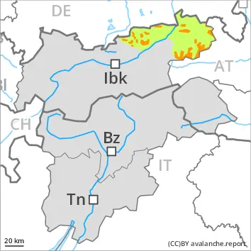
Remotely triggered and natural avalanches are to be expected.
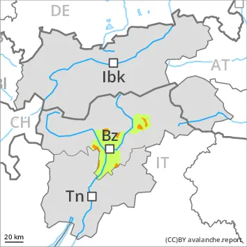
From the middle of the day a precarious avalanche situation will prevail. The avalanche danger in the regions exposed to heavier precipitation is within the upper range of danger level 3 (considerable).
Late morning: In particular on wind-loaded slopes avalanches can be triggered in the faceted old snow and reach medium size. This applies even in case of a single winter sport participant in some cases. Caution is to be exercised in particular on west, north and east facing slopes above approximately 1800 m.
Increase in avalanche danger from the middle of the day. As a consequence of new snow and a moderate to strong wind from variable directions, precarious wind slabs will form from the middle of the day. These can be released in near-surface layers of the snowpack. Avalanches can also penetrate near-ground layers of the snowpack and reach quite a large size on west, north and east facing slopes. Natural avalanches are to be expected. The runout zones are to be avoided. The emptied starting zones will be replenished as a consequence of snowfall and wind. In addition an appreciable danger of loose snow avalanches exists.
Snowpack
dp.1: deep persistent weak layer dp.8: surface hoar blanketed with snow
20 to 40 cm of snow, and even more in some localities, will fall from midday. The sometimes strong wind will transport the new snow. The snowpack will become increasingly prone to triggering. Somewhat older wind slabs are lying on surface hoar in some places. Over a wide area further wind slabs will form. Distinct weak layers exist in the old snowpack in particular on west, north and east facing slopes.
Tendency
During the course of the night as a consequence of new snow and wind there will be an additional increase in the avalanche danger. The snowpack will be prone to triggering over a wide area.
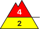
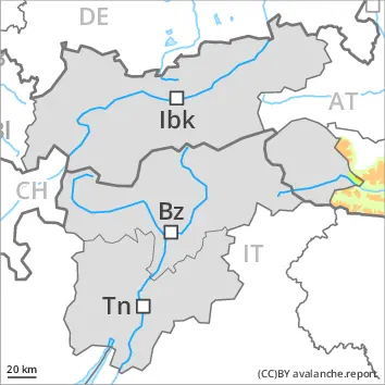
Danger level
treeline
Avalanche Problem
Persistent weak layer
Treeline
Wind slab
Treeline
Fresh wind slabs are to be evaluated critically. Weak layers in the old snowpack can be released in isolated cases.
Weak layers in the old snowpack can be released in isolated cases by individual winter sport participants especially in little used terrain. Caution is to be exercised in particular on steep west, north and east facing slopes above the tree line. The avalanche prone locations are difficult to recognise. Mostly avalanches are medium-sized.
In addition the wind slabs in gullies and bowls, and behind abrupt changes in the terrain are prone to triggering in some cases still. Such avalanche prone locations are to be found on north, east and southeast facing slopes above the tree line.
Restraint is advisable.
Snowpack
dp.1: deep persistent weak layer dp.8: surface hoar blanketed with snow
20 to 30 cm of snow, and even more in some localities, will fall from midday. The wind will be strong to storm force in some localities. The sometimes storm force wind will transport the new snow. Sometimes avalanche prone wind slabs will form.
The snowpack will be in some cases prone to triggering. The new snow and wind slabs are lying on top of a weakly bonded old snowpack. This applies in particular on west, north and east facing slopes above the tree line.
Tendency
Weak layers in the old snowpack represent the main danger.
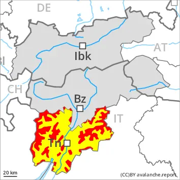
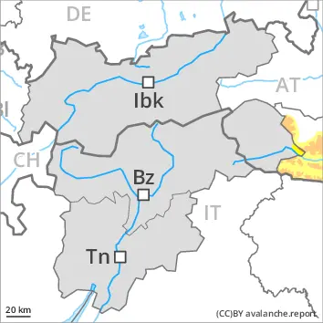
Danger level
treeline
Avalanche Problem
Wind slab
Treeline
Persistent weak layer
Treeline
Wind slabs and weakly bonded old snow require caution.
Avalanches can in some places be released by a single winter sport participant and reach medium size. The avalanche prone locations are to be found in gullies and bowls, and behind abrupt changes in the terrain, especially on steep north and east facing slopes above the tree line, but in isolated cases also in areas close to the tree line. The prevalence of the avalanche prone locations will increase from midday. Avalanches can in isolated cases be released in the weakly bonded old snow in particular in shady places that are protected from the wind. Whumpfing sounds and shooting cracks when stepping on the snowpack can indicate the danger.
Snowpack
dp.6: cold, loose snow and wind dp.1: deep persistent weak layer
15 to 30 cm of snow, and up to 40 cm in some localities, has fallen since Sunday. 10 to 20 cm of snow will fall on Thursday. The wind will be strong at times.
The fresh wind slabs are lying on soft layers. They are lying on surface hoar in some places. Faceted weak layers exist in the bottom section of the old snowpack in particular on west, north and east facing slopes.
Tendency
Over a wide area 5 to 15 cm of snow, and even more in some localities, will fall. Wind slabs and weakly bonded old snow require caution.