The conditions are very dangerous for winter sport activities outside marked and open pistes. Natural avalanches are to be expected in the second half of the day.
Weak layers in the old snowpack can be released very easily. Fresh wind slabs are to be evaluated critically.
The fresh snow and the sometimes large wind slabs that are forming in all aspects can be released very easily above the tree line. Such avalanche prone locations are to be found also in areas close to the tree line. Whumpfing sounds and the formation of shooting cracks when stepping on the snowpack and fresh avalanches serve as an alarm indicating the danger. Remotely triggered avalanches are possible.
The prevalence of the avalanche prone locations will increase from midday. As a consequence of new snow and strong wind more frequent natural avalanches are to be expected. Avalanches can in some cases penetrate deep layers and reach large size, especially on steep west, north and east facing slopes.
On very steep slopes small and, in isolated cases, medium-sized loose snow avalanches are possible, in the event of rain this also applies at low and intermediate altitudes.
Snowpack
dp.1: deep persistent weak layer dp.6: cold, loose snow and wind
Over a wide area 20 to 40 cm of snow, and even more in some localities, has fallen since Sunday. 15 to 30 cm of snow, and even more in some localities, will fall on Thursday. The wind will be strong in some cases. The wind will transport the new snow. Further wind slabs will form.
The snowpack will be prone to triggering over a wide area. The meteorological conditions will bring about a substantial weakening of the snowpack in the afternoon. The new snow and wind slabs are lying on top of a weakly bonded old snowpack. Somewhat older wind slabs are lying on surface hoar. Distinct weak layers exist in the bottom section of the old snowpack. This applies in particular on west, north and east facing slopes above the tree line.
Tendency
The off-piste conditions are very dangerous. Weak layers in the old snowpack represent the main danger.
10 to 20 cm of snow, and even more in some localities, will fall during the night. This applies in particular in the north.
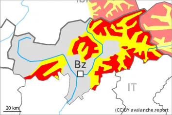
EARLIER Danger level
treeline
Avalanche Problem
Persistent weak layer
Treeline
Wind slab
Treeline
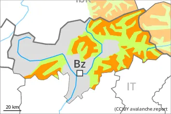
LATER Danger level
treeline
Avalanche Problem
Persistent weak layer
Treeline
Wind slab
Treeline
New snow
Increase in avalanche danger as a consequence of new snow and strong wind. Natural avalanches are to be expected.
Outside marked and open pistes a very dangerous avalanche situation will prevail. The danger exists in particular in alpine snow sports terrain.
The fresh snow and the sometimes large wind slabs that are forming in all aspects can be released very easily above the tree line. Such avalanche prone locations are to be found also in areas close to the tree line. Whumpfing sounds and the formation of shooting cracks when stepping on the snowpack and fresh avalanches serve as an alarm indicating the danger. Remotely triggered avalanches are possible.
The number and size of avalanche prone locations will increase from midday. As a consequence of new snow and strong wind more frequent natural avalanches are to be expected. Avalanches can in some cases penetrate deep layers and reach large size, especially on steep west, north and east facing slopes.
On very steep slopes small and, in isolated cases, medium-sized loose snow avalanches are possible, in the event of rain this also applies at low and intermediate altitudes.
Snowpack
dp.1: deep persistent weak layer dp.6: cold, loose snow and wind
15 to 30 cm of snow, and even more in some localities, will fall on Thursday. The wind will be strong in some cases. The wind will transport the new snow. Further wind slabs will form.
The snowpack will be prone to triggering over a wide area. The meteorological conditions will bring about a substantial weakening of the snowpack in the afternoon. The new snow and wind slabs are lying on top of a weakly bonded old snowpack. Somewhat older wind slabs are lying on surface hoar. Distinct weak layers exist in the bottom section of the old snowpack. This applies in particular on west, north and east facing slopes above the tree line.
Tendency
The off-piste conditions are very dangerous. Weak layers in the old snowpack represent the main danger.
10 to 20 cm of snow will fall during the night. This applies in particular in the north, in the Tuxer Alps, in the Zillertal Alps and in the High Tauern.
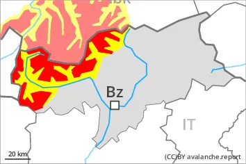
Danger level
treeline
Avalanche Problem
Persistent weak layer
Treeline
Wind slab
Treeline
Fresh wind slabs are to be evaluated critically. Weak layers in the old snowpack can be released in isolated cases.
Weak layers in the old snowpack can be released in isolated cases by individual winter sport participants especially in little used terrain. Caution is to be exercised in particular on steep west, north and east facing slopes above the tree line. The avalanche prone locations are difficult to recognise. Mostly avalanches are medium-sized.
In addition the wind slabs in gullies and bowls, and behind abrupt changes in the terrain are prone to triggering in some cases still. Such avalanche prone locations are to be found on north, east and southeast facing slopes above the tree line.
Restraint is advisable.
Snowpack
dp.1: deep persistent weak layer dp.8: surface hoar blanketed with snow
20 to 30 cm of snow, and even more in some localities, will fall from midday. The wind will be strong to storm force in some localities. The sometimes storm force wind will transport the new snow. Sometimes avalanche prone wind slabs will form.
The snowpack will be in some cases prone to triggering. The new snow and wind slabs are lying on top of a weakly bonded old snowpack. This applies in particular on west, north and east facing slopes above the tree line.
Tendency
Weak layers in the old snowpack represent the main danger.