A lot of snow will fall from early morning in some regions. Backcountry touring and other off-piste activities call for great restraint.
The new snow and wind slabs represent the main danger. Outside marked and open pistes a very precarious avalanche situation will be encountered over a wide area.
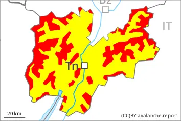
In some localities over a wide area 30 to 50 cm of snow, and even more in some localities, will fall. The new snow and wind slabs will be deposited on a weakly bonded old snowpack in particular on steep shady slopes above the tree line. The sometimes storm force wind will transport the new snow, especially at intermediate and high altitudes, as well as in gullies and bowls, and behind abrupt changes in the terrain at elevated altitudes. On very steep slopes natural avalanches must be expected. Mostly the avalanches are medium-sized and easily released. They can be released by small loads. In some places the avalanches can penetrate down to the ground and reach large size. Remotely triggered avalanches are possible. Whumpfing sounds and the formation of shooting cracks when stepping on the snowpack serve as an alarm indicating the danger. The avalanche prone locations are prevalent and are barely recognisable, even to the trained eye. Backcountry touring calls for meticulous route selection.
Snowpack
dp.6: cold, loose snow and wind dp.1: deep persistent weak layer
Over a wide area over a wide area 30 to 50 cm of snow, and even more in some localities, will fall. The sometimes storm force wind will transport the new snow. In all aspects wind slabs will form. The new snow and wind slabs are lying on top of a weakly bonded old snowpack. Distinct weak layers exist in the bottom section of the old snowpack. This applies in particular on west, north and east facing slopes above the tree line. The snowpack remains generally prone to triggering.
Tendency
The snowpack remains unstable over a wide area. The avalanche danger will persist.