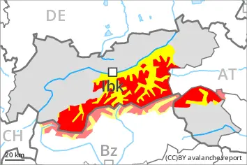
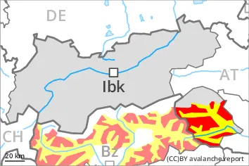
A very dangerous avalanche situation will prevail. The danger exists in particular in alpine snow sports terrain.
The large quantity of fresh snow and the extensive wind slabs that are being formed by the strong westerly wind are very prone to triggering in all aspects above the tree line. Such avalanche prone locations are to be found also in areas close to the tree line.
As a consequence of new snow and wind natural avalanches are to be expected until late in the night. Avalanches can in some cases penetrate deep layers and reach large size. This applies on west, north and east facing slopes.
With the end of the snowfall, the natural avalanche activity will slowly decrease. In particular in the regions exposed to the foehn wind more natural avalanches are possible as a consequence of the strong to storm force northwesterly wind. Caution is to be exercised in particular in leeward starting zones.
Snowpack
dp.1: deep persistent weak layer dp.6: cold, loose snow and wind
In some regions 10 to 20 cm of snow will fall until late morning. The wind will be moderate to strong. The wind will be storm force at times in particular in the Southern Zillertal Alps and High Tauern and along the border with South Tyrol. The wind will transport the new snow. Further wind slabs will form.
The snowpack will be prone to triggering over a wide area. The new snow and wind slabs are lying on top of a weakly bonded old snowpack. Somewhat older wind slabs are lying on surface hoar. Distinct weak layers exist in the bottom section of the old snowpack. This applies in particular on west, north and east facing slopes above the tree line.
Tendency
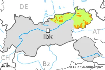
Some snow will fall in some regions. The rain will give rise to softening of the snowpack at low and intermediate altitudes. As a consequence of a sometimes storm force wind from westerly directions, further wind slabs will form on Saturday. The snow sport conditions outside marked and open pistes remain very dangerous. Avalanches can be released very easily. More natural avalanches are possible.
Danger level
treeline
Avalanche Problem
Persistent weak layer
Treeline
New snow
Treeline
Gliding snow
2400m
Natural avalanches are to be expected.
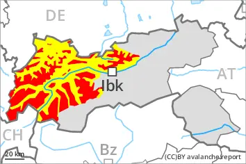
A very dangerous avalanche situation will persist.
The new snow and wind slabs are lying on top of a weakly bonded old snowpack. The large quantity of fresh snow and the extensive wind slabs that are being formed by the strong westerly wind are very prone to triggering in all aspects above the tree line. Such avalanche prone locations are to be found also in areas close to the tree line.
As a consequence of new snow and wind natural avalanches are to be expected during the course of the night. Avalanches can in some cases penetrate deep layers and reach large size. This applies on west, north and east facing slopes. Caution is to be exercised in particular in leeward starting zones that have retained the snow thus far. Avalanches can in very isolated cases reach very large size. Exposed transportation routes can be endangered occasionally.
With the end of the snowfall, the natural avalanche activity will gradually decrease.
Snowpack
dp.1: deep persistent weak layer dp.6: cold, loose snow and wind
Over a wide area 15 to 30 cm of snow will fall until late morning. The wind will be strong in some cases.
The snowpack will be prone to triggering. Large quantities of fresh snow and the wind-drifted snow are bonding only slowly with the old snowpack. The various wind slabs have bonded insufficiently with each other and the old snowpack. Avalanche prone weak layers exist in the bottom section of the snowpack on west, north and east facing slopes.
Released avalanches and reports filed by observers have confirmed poor snowpack stability.
Tendency
Some snow will fall in some regions. As a consequence of a sometimes storm force wind from westerly directions, further wind slabs will form on Saturday. The rain will give rise to softening of the snowpack at low and intermediate altitudes.
The snow sport conditions outside marked and open pistes remain very dangerous. Avalanches can be released very easily. Natural avalanches are possible.
Danger level
treeline
Avalanche Problem
Persistent weak layer
Treeline
Wind slab
Treeline
New snow
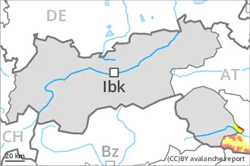
The conditions are very dangerous for winter sport activities outside marked and open pistes. Remotely triggered and natural avalanches are to be expected.
The conditions are very dangerous for winter sport activities outside marked and open pistes. Remotely triggered and natural avalanches are to be expected.
Wind slabs are very prone to triggering in all aspects. These can be released in near-surface layers of the snowpack. Avalanches can also penetrate near-ground layers of the snowpack and reach large size on west, north and east facing slopes. Natural avalanches are to be expected. This applies especially at the base of rock walls and behind abrupt changes in the terrain. Caution is to be exercised, including in areas close to the tree line. The runout zones are to be avoided.
In addition an appreciable danger of loose snow avalanches exists.
Snowpack
dp.1: deep persistent weak layer dp.8: surface hoar blanketed with snow
30 to 50 cm of snow, and even more in some localities, has fallen since Thursday. The northwesterly wind will transport the new snow. Over a wide area further wind slabs will form. Somewhat older wind slabs are lying on surface hoar in some places. The snowpack will become increasingly prone to triggering. Distinct weak layers exist in the old snowpack in particular on west, north and east facing slopes.
Tendency
The snowpack remains prone to triggering. As a consequence of warming, the likelihood of avalanches being released will increase.
Danger level
treeline
Avalanche Problem
Persistent weak layer
Treeline
Wind slab
Treeline
New snow
Treeline
The conditions are very dangerous for winter sport activities outside marked and open pistes. Remotely triggered and natural avalanches are to be expected.
Outside marked and open pistes a very dangerous avalanche situation will prevail. The danger exists in particular in alpine snow sports terrain.
Wind slabs are very prone to triggering in all aspects above the tree line, caution is to be exercised, including in areas close to the tree line. Avalanches can be released in near-surface layers of the snowpack. Additionally avalanches can also penetrate near-ground layers of the snowpack and reach large size on west, north and east facing slopes. Whumpfing sounds and the formation of shooting cracks when stepping on the snowpack and fresh avalanches serve as an alarm indicating the danger. Remotely triggered avalanches are possible.
As a consequence of the strong to storm force foehn wind from the north more natural avalanches are to be expected. This applies in case of releases originating from very steep leeward starting zones, in particular at the base of rock walls and behind abrupt changes in the terrain.
On very steep slopes small and medium-sized loose snow avalanches are possible.
Snowpack
dp.1: deep persistent weak layer dp.6: cold, loose snow and wind
20 to 40 cm of snow has fallen since Thursday. On Friday the wind will be strong to storm force. The wind will transport the new snow. Further wind slabs will form.
The snowpack will be prone to triggering over a wide area. The new snow and wind slabs are lying on top of a weakly bonded old snowpack. Somewhat older wind slabs are lying on surface hoar. Distinct weak layers exist in the bottom section of the old snowpack. This applies in particular on west, north and east facing slopes above the tree line.
Tendency
The off-piste conditions are very dangerous. Weak layers in the old snowpack represent the main danger.
Danger level
treeline
Avalanche Problem
Wind slab
Treeline
Persistent weak layer
Treeline
Wind slabs and weakly bonded old snow require caution. The avalanche prone locations are to be found in areas close to the tree line and above the tree line.
The fresh wind slabs can in some places be released very easily and reach medium size. The avalanche prone locations are to be found in gullies and bowls, and behind abrupt changes in the terrain, caution is to be exercised in areas close to the tree line, and above the tree line. The wind slabs will be covered with new snow in some cases and therefore difficult to recognise. Avalanches can additionally be released in the weakly bonded old snow in particular in shady places that are protected from the wind. Whumpfing sounds and shooting cracks when stepping on the snowpack can indicate the danger.
Snowpack
dp.6: cold, loose snow and wind dp.1: deep persistent weak layer
5 to 15 cm of snow will fall during the night. The wind will be moderate.
The fresh wind slabs are lying on soft layers. They are lying on surface hoar in some places. Faceted weak layers exist in the bottom section of the old snowpack in particular on west, north and east facing slopes.
Tendency
Some snow will fall. The rain will give rise to softening of the snowpack at low and intermediate altitudes. Wind slabs and weakly bonded old snow require caution.