Even single freeriders can release avalanches very easily.
A dangerous avalanche situation will prevail. The danger exists in particular in alpine snow sports terrain.
The new snow and wind slabs of the last few days are lying on top of a weakly bonded old snowpack. The fresh snow of Saturday and the wind slabs formed by the strong to storm force westerly wind remain prone to triggering in all aspects above the tree line. Winter sport participants can release avalanches easily. Avalanches can in some cases penetrate deep layers and reach large size. This applies on west, north and east facing slopes. The avalanche prone locations are numerous, especially in areas close to the tree line, as well as above the tree line. Very isolated natural avalanches are further not entirely ruled out.
In addition some wet and gliding avalanches are possible. This applies especially on cut and grassy slopes below approximately 1800 m.
Snowpack
dp.1: deep persistent weak layer dp.6: cold, loose snow and wind
A lot of snow fell in the last few days in some regions. Some snow will fall on Monday. The wind will be strong in some cases. The wind will transport the new snow. Further wind slabs will form. Up to intermediate altitudes rain has fallen.
The snowpack will be prone to triggering over a wide area. The new snow and wind slabs are lying on top of a weakly bonded old snowpack. Somewhat older wind slabs are lying on surface hoar. Distinct weak layers exist in the bottom section of the old snowpack. This applies in particular on west, north and east facing slopes above the tree line.
The weather conditions as the day progresses will give rise to gradual and thorough wetting of the snowpack at low and intermediate altitudes, especially on steep sunny slopes.
Tendency
Gradual decrease in avalanche danger.
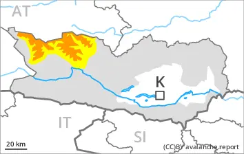
Danger level
1800m
Avalanche Problem
Persistent weak layer
1800m
Wet snow
Increase in danger of wet avalanches as a consequence of warming.
As a consequence of warming during the day and solar radiation small and, in isolated cases, medium-sized wet loose snow avalanches are possible. In addition especially at the base of rock walls, individual small and medium-sized wet avalanches are possible. This applies in particular on very steep sunny slopes. The runout zones are to be treated with caution.
Avalanches can be released in the old snowpack and reach medium size on west, north and east facing slopes. This applies even in case of a single winter sport participant in some cases, especially above approximately 1800 m on northwest, north and northeast facing slopes. In their paths avalanches can entrain the wet snow. This extends the avalanche runout distances.
Snowpack
dp.10: springtime scenario dp.1: deep persistent weak layer
30 to 50 cm of snow, and even more in some localities, fell in the last few days. Outgoing longwave radiation during the night will be reduced. The weather conditions as the day progresses will give rise to gradual and thorough wetting of the snowpack. This applies in particular on very steep sunny slopes. Distinct weak layers exist in the old snowpack in particular on west, north and east facing slopes.
Tendency
The activity of wet avalanches will gradually increase.
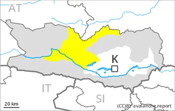
Danger level
treeline
Avalanche Problem
Persistent weak layer
Treeline
Wet snow
2200m
Shady slopes: Weakly bonded old snow requires caution. Very steep sunny slopes: Increase in danger of wet avalanches as a consequence of warming.
Avalanches can be released in the old snowpack and reach large size in isolated cases on west, north and east facing slopes. This applies in case of a single winter sport participant. The avalanche prone locations are to be found in particular above the tree line. In their paths avalanches can entrain the wet snow. This extends the avalanche runout distances.
As a consequence of warming during the day and solar radiation small and medium-sized wet avalanches are possible. This applies in particular on very steep sunny slopes below approximately 2200 m. The runout zones are to be treated with caution.
Snowpack
dp.1: deep persistent weak layer dp.10: springtime scenario
20 to 40 cm of snow, and up to 60 cm in some localities, fell in the last few days. Distinct weak layers exist in the old snowpack in particular on west, north and east facing slopes. Outgoing longwave radiation during the night will be reduced. The weather conditions as the day progresses will give rise to gradual and thorough wetting of the snowpack. This applies on very steep sunny slopes below approximately 2200 m.
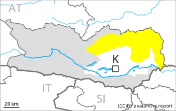
Tendency
The activity of wet avalanches will gradually increase.
Danger level
treeline
Avalanche Problem
Persistent weak layer
Treeline
Wind slab
2200m
Wet snow
2200m
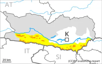
Outside marked and open pistes a precarious avalanche situation will prevail. Weakly bonded old snow requires caution.
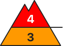
Wind slabs are very prone to triggering in all aspects above approximately 2000 m. These can in many cases be released in near-surface layers of the snowpack. Avalanches can also penetrate near-ground layers of the snowpack and reach large size on west, north and east facing slopes. As a consequence of the strong foehn wind from the north individual natural avalanches are possible. The runout zones are to be avoided. Remotely triggered avalanches are possible.
In the regions neighbouring those that are subject to danger level 4 (high) the avalanche prone locations are larger.
As a consequence of warming during the day small and, in isolated cases, medium-sized wet loose snow avalanches are possible. In addition a latent danger of gliding avalanches exists.
Snowpack
dp.1: deep persistent weak layer dp.6: cold, loose snow and wind
30 to 50 cm of snow, and even more in some localities, has fallen since Thursday. As a consequence of new snow and strong wind the wind slabs will increase in size once again. Somewhat older wind slabs are lying on surface hoar in some places. Distinct weak layers exist in the old snowpack in particular on west, north and east facing slopes. Avalanches triggered by explosives and natural avalanches have confirmed the existence of a weak snowack.
Outgoing longwave radiation during the night will be reduced. The weather conditions as the day progresses will give rise to gradual and thorough wetting of the snowpack. This applies on very steep sunny slopes below approximately 2200 m.
Tendency
The snowpack remains prone to triggering. As a consequence of warming, the likelihood of moist avalanches being released will increase.
Danger level
1800m
Avalanche Problem
Persistent weak layer
1800m
Wet snow
Shady slopes: Weakly bonded old snow requires caution. Very steep sunny slopes: Increase in danger of wet avalanches as a consequence of warming.
Avalanches can be released in the old snowpack and reach medium size on west, north and east facing slopes. This applies in case of a single winter sport participant, especially above approximately 1800 m. In their paths avalanches can entrain the wet snow. This extends the avalanche runout distances.
As a consequence of warming during the day and solar radiation small and, in isolated cases, medium-sized wet loose snow avalanches are possible. In addition especially at the base of rock walls, individual small and medium-sized wet avalanches are possible. The runout zones are to be treated with caution.
Snowpack
dp.1: deep persistent weak layer dp.10: springtime scenario
15 to 25 cm of snow, and even more in some localities, fell in the last few days. Distinct weak layers exist in the old snowpack in particular on west, north and east facing slopes. Outgoing longwave radiation during the night will be reduced. The weather conditions as the day progresses will give rise to gradual and thorough wetting of the snowpack. This applies in particular on very steep sunny slopes.
Tendency
The activity of wet avalanches will gradually increase.
Danger level
Avalanche Problem
Wet snow
Wet snow requires caution.
As a consequence of warming during the day and solar radiation mostly small wet loose snow avalanches are possible. In addition especially in the vicinity of peaks, individual small and medium-sized wet avalanches are possible. The runout zones are to be treated with caution. In addition a latent danger of gliding avalanches exists.
Snowpack
dp.10: springtime scenario dp.1: deep persistent weak layer
20 to 40 cm of snow fell in the last few days. Outgoing longwave radiation during the night will be reduced. The weather conditions as the day progresses will give rise to gradual and thorough wetting of the snowpack. Distinct weak layers exist in the old snowpack in particular on west, north and east facing slopes.
Tendency
The activity of wet avalanches will gradually increase.