Even single freeriders can release avalanches easily.
For those venturing off piste a dangerous avalanche situation will persist.
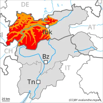
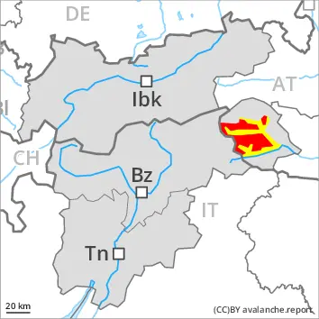
Large quantities of fresh snow and the wind-drifted snow of the last few days are lying on top of a weakly bonded old snowpack. Areas close to the tree line as well as above the tree line: Winter sport participants can release avalanches easily. Avalanches can in some cases penetrate deep layers and reach large size, in particular on west, north and east facing slopes. The avalanche prone locations are numerous. Individual avalanche prone locations are to be found also on southeast, south and southwest facing slopes above approximately 2600 m. Caution is to be exercised in particular in little used terrain, as well as at transitions from a shallow to a deep snowpack, when entering gullies and bowls for example. Remotely triggered avalanches are possible.
As a consequence of the rain, the likelihood of wet slab avalanches being released will increase in all aspects below approximately 2000 m. In particular on very steep west, north and east facing slopes the wet avalanches can penetrate even deep layers and reach large size in isolated cases.
In addition gliding avalanches are possible. This applies especially on cut and grassy slopes below approximately 2000 m.
Snowpack
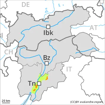
dp.7: snow-poor zones in snow-rich surrounding dp.3: rain
Tuesday: Up to 15 cm of snow, and even more in some localities, will fall above approximately 2000 m. Up to intermediate altitudes rain will fall. The wind will be strong to storm force in some cases.
The snowpack will be prone to triggering. Large quantities of fresh snow and the wind-drifted snow of the last few days are bonding only slowly with the old snowpack. The various wind slabs have bonded insufficiently with each other and the old snowpack. Avalanche prone weak layers exist in the bottom section of the snowpack on west, north and east facing slopes.
The rain gave rise to softening of the snowpack at low and intermediate altitudes.
Tendency
Hardly any decrease in danger of dry avalanches. Gradual increase in danger of wet avalanches as a consequence of warming.
Danger level
treeline
Avalanche Problem
Persistent weak layer
Treeline
Wind slab
Treeline
Wet snow
2200m
Outside marked and open pistes a dangerous avalanche situation will prevail.
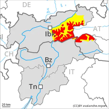
Wind slabs remain prone to triggering. Caution is to be exercised in particular on west, north and east facing slopes in areas close to the tree line, as well as above the tree line. Individual avalanche prone locations are to be found also on southeast, south and southwest facing slopes above approximately 2400 m. Avalanches can be released in near-surface layers of the snowpack. Additionally avalanches can also be released in deep layers and reach large size on west, north and east facing slopes. Whumpfing sounds and the formation of shooting cracks when stepping on the snowpack and fresh avalanches serve as an alarm indicating the danger. Remotely triggered avalanches are possible.
As a consequence of warming during the day and solar radiation wet loose snow avalanches are possible. This applies especially on very steep sunny slopes below approximately 2200 m.
Snowpack
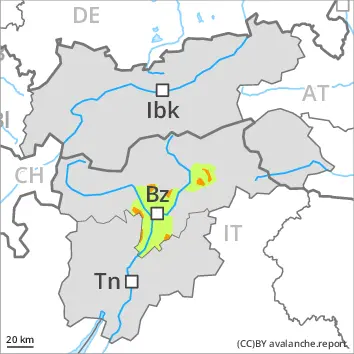
dp.1: deep persistent weak layer
5 to 10 cm of snow, and even more in some localities, will fall. The sometimes storm force wind will transport the snow. Further wind slabs will form.
The snowpack will be prone to triggering over a wide area. The new snow and wind slabs are lying on the unfavourable surface of an old snowpack. Distinct weak layers exist in the bottom section of the old snowpack. This applies in particular on west, north and east facing slopes in areas close to the tree line, and above the tree line.
The weather conditions as the day progresses will give rise to thorough wetting of the snowpack. This applies especially on very steep sunny slopes below approximately 2200 m.
Tendency
Gradual decrease in danger of dry avalanches. Increase in danger of wet avalanches as a consequence of warming.
Danger level
treeline
Avalanche Problem
Persistent weak layer
Treeline
Wind slab
Treeline
Wet snow
2200m
Outside marked and open pistes a dangerous avalanche situation will prevail.
Wind slabs remain prone to triggering. Caution is to be exercised in particular on west, north and east facing slopes in areas close to the tree line, as well as above the tree line. Individual avalanche prone locations are to be found also on southeast, south and southwest facing slopes above approximately 2400 m. Avalanches can be released in near-surface layers of the snowpack. Additionally avalanches can also be released in deep layers and reach large size on west, north and east facing slopes. Whumpfing sounds and the formation of shooting cracks when stepping on the snowpack and fresh avalanches serve as an alarm indicating the danger. Remotely triggered avalanches are possible.
As a consequence of warming during the day and solar radiation wet loose snow avalanches are possible. This applies especially on very steep sunny slopes below approximately 2200 m.
Snowpack
dp.1: deep persistent weak layer
5 to 10 cm of snow, and even more in some localities, will fall. The sometimes storm force wind will transport the snow. Further wind slabs will form.
The snowpack will be prone to triggering over a wide area. The new snow and wind slabs are lying on the unfavourable surface of an old snowpack. Distinct weak layers exist in the bottom section of the old snowpack. This applies in particular on west, north and east facing slopes in areas close to the tree line, and above the tree line.
The weather conditions as the day progresses will give rise to thorough wetting of the snowpack. This applies especially on very steep sunny slopes below approximately 2200 m.
Tendency
Gradual decrease in danger of dry avalanches. Increase in danger of wet avalanches as a consequence of warming.
Danger level
treeline
Avalanche Problem
Persistent weak layer
Treeline
Wind slab
Treeline
Wet snow
1800m
Even single winter sport participants can release avalanches easily.
In little used terrain a dangerous avalanche situation will prevail.
As a consequence of new snow and a strong to storm force northwesterly wind, further wind slabs will form in gullies and bowls and behind abrupt changes in the terrain. The new snow and wind slabs of the last few days are lying on top of a weakly bonded old snowpack. This applies on west, north and east facing slopes. The avalanche prone locations are numerous, especially in areas close to the tree line, as well as above the tree line. Winter sport participants can release avalanches easily, including large ones. Natural avalanches are still even now possible.
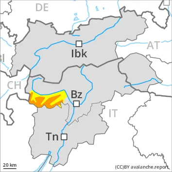
In addition wet and gliding avalanches are possible. This applies especially on cut and grassy slopes below approximately 1800 m. In places where a lot of rain falls the avalanche danger is greater. This applies in particular in the Kitzbühel Alps.
Snowpack
dp.1: deep persistent weak layer dp.6: cold, loose snow and wind
15 to 30 cm of snow, and even more in some localities, will fall on Tuesday. The wind will be strong to storm force in some cases. The wind will transport the new snow. Further wind slabs will form.
The snowpack will be prone to triggering over a wide area. The new snow and wind slabs are lying on top of a weakly bonded old snowpack. Distinct weak layers exist in the bottom section of the old snowpack. This applies in particular on west, north and east facing slopes in areas close to the tree line, and above the tree line.
The rain will give rise as the day progresses to gradual and thorough wetting of the snowpack at low altitude.
Tendency
Hardly any decrease in danger of dry avalanches. Gradual increase in danger of wet avalanches as a consequence of warming.
Danger level
treeline
Avalanche Problem
Wind slab
Treeline
Persistent weak layer
Treeline
Wet snow
1800m
Wind slabs and weakly bonded old snow require caution.
The new snow and wind slabs are lying on top of a weakly bonded old snowpack. As a consequence of new snow and a storm force wind, further wind slabs will form. The avalanche prone locations are numerous, especially in areas close to the tree line, as well as above the tree line. Even single winter sport participants can release avalanches easily.
As a consequence of the rain, the likelihood of wet avalanches being released will increase. This applies especially on cut and grassy slopes below approximately 1800 m.
Snowpack
dp.6: cold, loose snow and wind dp.1: deep persistent weak layer
20 to 40 cm of snow, and even more in some localities, fell in the past few hours. In some regions in some regions up to 20 cm of snow will fall until midday. The wind will be strong in some cases. More rain than expected has fallen, in particular at low altitude.
The wind will transport the snow. Further wind slabs will form.
The snowpack will be prone to triggering over a wide area. The new snow and wind slabs are lying on top of a weakly bonded old snowpack. Somewhat older wind slabs are lying on surface hoar. Distinct weak layers exist in the bottom section of the old snowpack. This applies in particular on west, north and east facing slopes above the tree line. The rain will give rise to extreme and thorough wetting of the snowpack at low altitude.
Tendency
Gradual decrease in danger of dry avalanches. Increase in danger of wet avalanches as a consequence of warming.
Danger level
treeline
Avalanche Problem
Persistent weak layer
Treeline
Wind slab
2000m
Wet snow
2200m
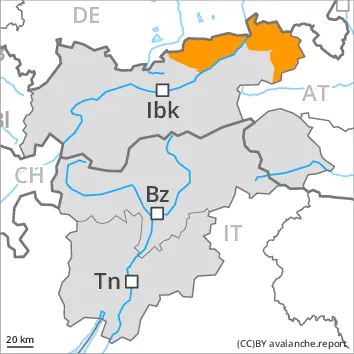
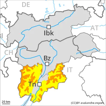
The avalanche danger is within the uppermost range of danger level 3 (considerable).
Shady slopes: Weakly bonded old snow requires caution. Very steep sunny slopes: Increase in danger of wet avalanches as a consequence of warming.
Avalanches can be released in the old snowpack and reach large size in isolated cases on west, north and east facing slopes. This applies in case of a single winter sport participant. The avalanche prone locations are to be found in particular above the tree line. In their paths avalanches can entrain the wet snow. This extends the avalanche runout distances.
Wind slabs remain prone to triggering. Caution is to be exercised in particular on west, north and east facing slopes above the tree line, as well as in gullies and bowls, and behind abrupt changes in the terrain.
As a consequence of warming during the day and solar radiation small and medium-sized wet avalanches are possible. This applies in particular on very steep sunny slopes below approximately 2200 m. The runout zones are to be treated with caution as well.
Snowpack
dp.1: deep persistent weak layer dp.10: springtime scenario
The sometimes storm force wind will transport the snow. Further wind slabs will form. Distinct weak layers exist in the old snowpack in particular on west, north and east facing slopes.
Outgoing longwave radiation during the night will be reduced at times. The weather conditions as the day progresses will give rise to thorough wetting of the snowpack. This applies on very steep sunny slopes below approximately 2200 m.
Tendency
Hardly any decrease in avalanche danger. The activity of wet avalanches will gradually increase.
Danger level
treeline
Avalanche Problem
Wind slab
Treeline
Persistent weak layer
Treeline
Wet snow
2500m
Backcountry touring and other off-piste activities call for great restraint.
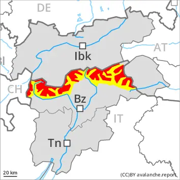
The new snow and wind slabs represent the main danger. Outside marked and open pistes a very precarious avalanche situation will be encountered over a wide area. Very steep sunny slopes: Increase in danger of wet avalanches as a consequence of warming.
The sometimes storm force wind has transported a lot of snow. Above the tree line avalanche prone wind slabs formed, especially adjacent to ridgelines and in pass areas in all altitude zones, as well as in gullies and bowls, and behind abrupt changes in the terrain at elevated altitudes. On very steep sunny slopes medium-sized natural avalanches must be expected. In some places the avalanches can penetrate down to the ground and reach large size. Mostly the dry avalanches are medium-sized and can be released by a single winter sport participant. Remotely triggered avalanches are possible. Whumpfing sounds and the formation of shooting cracks when stepping on the snowpack serve as an alarm indicating the danger. The avalanche prone locations are prevalent and are barely recognisable, even to the trained eye. Backcountry touring calls for meticulous route selection.
Snowpack
dp.1: deep persistent weak layer dp.6: cold, loose snow and wind
Over a wide area over a wide area 20 to 40 cm of snow, and up to 50 cm in some localities, has fallen since Thursday. The new snow and wind slabs are lying on top of a weakly bonded old snowpack in particular on steep shady slopes above the tree line. Distinct weak layers exist in the bottom section of the old snowpack. The meteorological conditions will foster a gradual weakening of the snowpack on sunny slopes. The snowpack remains unstable over a wide area, especially adjacent to ridgelines and in pass areas in all altitude zones, as well as in gullies and bowls, and behind abrupt changes in the terrain at elevated altitudes.
Tendency
The snowpack remains prone to triggering over a wide area. The avalanche danger will persist. The activity of wet avalanches will gradually increase.
Danger level
treeline
Avalanche Problem
Persistent weak layer
Treeline
Wet snow
2200m
Shady slopes: Weakly bonded old snow requires caution. Very steep sunny slopes: Increase in danger of wet avalanches as a consequence of warming.
Avalanches can be released in the old snowpack and reach large size in isolated cases on west, north and east facing slopes. This applies in case of a single winter sport participant. The avalanche prone locations are to be found in particular above the tree line. In their paths avalanches can entrain the wet snow. This extends the avalanche runout distances.
As a consequence of warming during the day and solar radiation small and medium-sized wet avalanches are possible. This applies in particular on very steep sunny slopes below approximately 2200 m. The runout zones are to be treated with caution.
Snowpack
dp.1: deep persistent weak layer dp.10: springtime scenario
Distinct weak layers exist in the old snowpack in particular on west, north and east facing slopes.
Outgoing longwave radiation during the night will be reduced at times. The weather conditions as the day progresses will give rise to thorough wetting of the snowpack. This applies on very steep sunny slopes below approximately 2200 m.
Tendency
The activity of wet avalanches will increase.
Danger level
treeline
Avalanche Problem
Persistent weak layer
Treeline
Wind slab
2200m
Wet snow
2200m
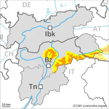
Outside marked and open pistes a precarious avalanche situation will prevail. Weakly bonded old snow requires caution. In addition the danger of wet avalanches will increase.
Wind slabs are very prone to triggering in all aspects above approximately 2000 m. These can in many cases be released in near-surface layers of the snowpack. Avalanches can also penetrate near-ground layers of the snowpack and reach large size on west, north and east facing slopes. As a consequence of the strong northwesterly wind individual natural avalanches are possible. The runout zones are to be avoided. Remotely triggered avalanches are possible.
In the regions neighbouring those that are subject to danger level 4 (high) the avalanche prone locations are larger.
As the penetration by moisture increases small and medium-sized wet avalanches are possible. In the event of rain this applies especially below approximately 2200 m. In addition a latent danger of gliding avalanches exists. This applies in particular on cut and grassy slopes.
Snowpack
dp.1: deep persistent weak layer dp.6: cold, loose snow and wind
10 to 20 cm of snow, and even more in some localities, will fall. As a consequence of new snow and strong wind the wind slabs will increase in size additionally. Somewhat older wind slabs are lying on surface hoar in some places. Distinct weak layers exist in the old snowpack in particular on west, north and east facing slopes. Avalanches triggered by explosives and natural avalanches have confirmed the existence of a weak snowack.
Outgoing longwave radiation during the night will be reduced. The weather conditions as the day progresses will give rise to gradual and thorough wetting of the snowpack. In the event of rain this applies especially below approximately 2200 m.
Tendency
The snowpack remains prone to triggering. The activity of wet avalanches will gradually increase.
Danger level
treeline
Avalanche Problem
Persistent weak layer
Treeline
Wind slab
Treeline
Wet snow
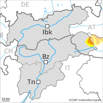
Fresh wind slabs are to be evaluated critically. Weak layers in the old snowpack can be released in isolated cases.
Weak layers in the old snowpack can be released in isolated cases by individual winter sport participants especially in little used terrain. Caution is to be exercised in particular on steep west, north and east facing slopes above the tree line. The avalanche prone locations are difficult to recognise. Mostly avalanches are medium-sized.
In addition the wind slabs in gullies and bowls, and behind abrupt changes in the terrain are prone to triggering in some cases still. Such avalanche prone locations are to be found on north, east and southeast facing slopes above the tree line.
As a consequence of warming during the day and solar radiation small and medium-sized wet avalanches are possible. This applies in particular on very steep sunny slopes below approximately 2200 m. Restraint is advisable.
Snowpack
dp.1: deep persistent weak layer dp.6: cold, loose snow and wind
The sometimes storm force wind has transported some snow. Sometimes avalanche prone wind slabs formed.
The snowpack will be in some cases prone to triggering. The new snow and wind slabs are lying on top of a weakly bonded old snowpack. This applies in particular on west, north and east facing slopes above the tree line. The meteorological conditions will foster a gradual weakening of the snowpack on sunny slopes.
Tendency
Weak layers in the old snowpack represent the main danger.
Danger level
treeline
Avalanche Problem
Persistent weak layer
Treeline
Wet snow
2200m
Fresh wind slabs are to be evaluated critically. Weak layers in the old snowpack can be released in isolated cases.
Avalanches can in isolated cases be released in the old snowpack and reach medium size on west, north and east facing slopes. This applies in case of a single winter sport participant. In their paths avalanches can entrain the wet snow. This extends the avalanche runout distances.
As a consequence of warming during the day and solar radiation small and medium-sized wet avalanches are possible. This applies in particular on very steep sunny slopes below approximately 2200 m.
Snowpack
dp.1: deep persistent weak layer dp.8: surface hoar blanketed with snow
Distinct weak layers exist in the old snowpack in particular on west, north and east facing slopes.
Outgoing longwave radiation during the night will be reduced at times. The weather conditions as the day progresses will give rise to thorough wetting of the snowpack. This applies on very steep sunny slopes below approximately 2200 m.
Tendency
The activity of wet avalanches will gradually increase.