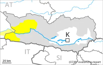
Weakly bonded old snow and wet snow require caution.
Avalanches can be released in the old snowpack and reach large size in particular on west, north and east facing slopes. This applies even in case of a single winter sport participant. The avalanche prone locations are to be found especially on west, north and east facing slopes above approximately 2000 m and in all aspects at elevated altitudes. Caution is to be exercised in particular at transitions from a shallow to a deep snowpack. Whumpfing sounds can indicate the danger. Remotely triggered avalanches are possible. In their paths avalanches can entrain the wet snow. This extends the avalanche runout distances.
As the moisture increases small to medium-sized wet avalanches are to be expected. In the event of an overcast night this applies in particular. Caution is to be exercised in particular below approximately 2200 m. The runout zones are to be treated with caution.
Snowpack
dp.1: deep persistent weak layer dp.10: springtime scenario
On Sunday it will be mild over a wide area. Outgoing longwave radiation during the night will be reduced at times.
Shady slopes: The snowpack remains prone to triggering in some places. Distinct weak layers exist in the old snowpack in particular on west, north and east facing slopes.
Sunny slopes: The surface of the snowpack will only just freeze and will already soften in the late morning. The weather conditions gave rise to thorough wetting of the snowpack below approximately 2200 m.
Tendency
Weakly bonded old snow and wet snow are to be assessed with care and prudence.
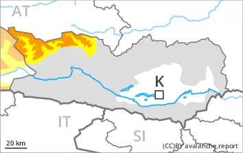
Danger level
2000m
Avalanche Problem
Persistent weak layer
2000m
Wet snow
2200m
Weakly bonded old snow and wet snow represent the main danger.
Avalanches can be released in the old snowpack and reach quite a large size on west, north and east facing slopes. This applies even in case of a single winter sport participant in some cases. The avalanche prone locations are to be found in particular above approximately 2000 m. Caution is to be exercised in particular at transitions from a shallow to a deep snowpack, when entering gullies and bowls for example. In their paths avalanches can entrain the wet snow. This extends the avalanche runout distances.
More small and medium-sized wet avalanches are possible below approximately 2200 m. The runout zones are to be treated with caution.
Snowpack
dp.1: deep persistent weak layer dp.10: springtime scenario
On Sunday it will be mild over a wide area. Outgoing longwave radiation during the night will be reduced at times.
Shady slopes: The snowpack remains prone to triggering in some places. Distinct weak layers exist in the old snowpack in particular on west, north and east facing slopes. This applies especially above approximately 2000 m.
Sunny slopes: The surface of the snowpack will only just freeze and will soften quickly. The weather conditions gave rise to thorough wetting of the snowpack below approximately 2200 m.
Tendency
Weakly bonded old snow and wet snow require caution.
Danger level
2000m
Avalanche Problem
Wet snow
2000m
Persistent weak layer
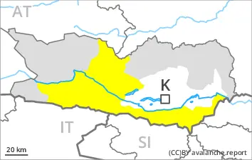
1900m
Wet snow requires caution. Weakly bonded old snow requires caution.
More small to medium-sized wet avalanches are possible, in particular on very steep sunny slopes, and at the base of rock walls below approximately 2000 m.
Additionally in isolated cases avalanches can also be released in the old snowpack and reach medium size. This applies even in case of a single winter sport participant in isolated cases, especially at elevated altitudes on northwest, north and northeast facing slopes. In their paths avalanches can entrain the wet snow. This extends the avalanche runout distances.
Snowpack
dp.10: springtime scenario dp.1: deep persistent weak layer
On Sunday it will be mild over a wide area. Outgoing longwave radiation during the night will be reduced at times.
Sunny slopes: The surface of the snowpack will only just freeze and will soften quickly. The weather conditions gave rise to thorough wetting of the snowpack. This applies especially on very steep sunny slopes, as well as at the base of rock walls.
Shady slopes: Distinct weak layers exist in the old snowpack on west, north and east facing slopes. This applies especially at elevated altitudes.
Tendency
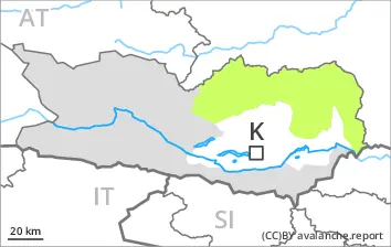
Wet snow requires caution.
Danger level
Avalanche Problem
Wet snow
Wet snow requires caution.
More mostly small wet avalanches are possible. This applies especially on very steep sunny slopes. The runout zones are to be treated with caution.
Snowpack
dp.10: springtime scenario dp.1: deep persistent weak layer
On Sunday it will be mild over a wide area.
Outgoing longwave radiation during the night will be reduced at times. The weather conditions gave rise to thorough wetting of the snowpack. Individual weak layers exist in the old snowpack on northwest, north and northeast facing slopes.