Danger level
 | 2000m |
|  |
|  | ||||
|  |
|  |


![]()
Weakly bonded old snow represents the main danger.
Weakly bonded old snow requires caution.
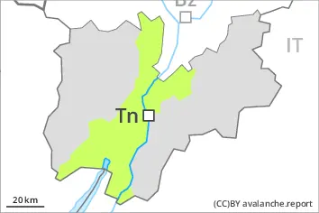
Avalanches can in some cases be released in the old snowpack and reach quite a large size on west, north and east facing slopes. This applies even in case of a single winter sport participant in some cases. The avalanche prone locations are to be found in particular above approximately 2000 m. Caution is to be exercised in particular at transitions from a shallow to a deep snowpack, when entering gullies and bowls for example.
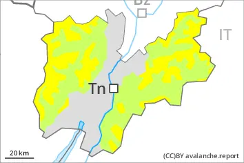
In the late morning the likelihood of slab avalanches being released will increase a little in particular on steep sunny slopes at elevated altitudes. As a consequence of warming during the day individual mostly small wet loose snow avalanches are possible. Backcountry tours and off-piste skiing should be concluded timely.
Snowpack
dp.1: deep persistent weak layer
dp.10: springtime scenario
Shady slopes: Distinct weak layers exist in the bottom section of the snowpack in particular on west, north and east facing slopes. This applies especially above approximately 2000 m.
Outgoing longwave radiation during the night will be reduced in some case. The surface of the snowpack will freeze to form a strong crust only at high altitudes. The weather conditions as the day progresses will give rise to softening of the snowpack in particular on sunny slopes.
Towards its surface, the snowpack consists of faceted crystals, especially on shady slopes at elevated altitudes.
In steep terrain there is a danger of falling on the hard snow surface.
Tendency
The weather will be mild. The danger of moist and wet avalanches will increase a little during the day.