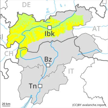
Winter sport participants can release avalanches in isolated cases. These can reach large size in isolated cases. The avalanche prone locations are to be found in particular on very steep west, north and east facing slopes above approximately 2000 m. Caution is to be exercised in particular at transitions from a shallow to a deep snowpack, when entering gullies and bowls for example.
As a consequence of warming during the day and the solar radiation, the likelihood of slab avalanches being released will increase a little on very steep west and east facing slopes below approximately 2200 m.
Snowpack
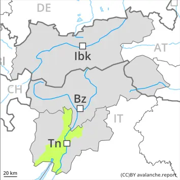
dp.7: snow-poor zones in snow-rich surrounding
Above approximately 2000 m: Avalanche prone weak layers exist in the bottom section of the snowpack on west, north and east facing slopes. Towards its surface, the snowpack consists of faceted crystals. This applies on shady slopes.
Below approximately 2000 m and steep sunny slopes: The old snowpack will be moist. The weather conditions as the day progresses will give rise to gradual moistening of the snowpack.
Tendency
Weakly bonded old snow requires caution.
5 to 15 cm of snow will fall until Sunday. As a consequence of wind, mostly small wind slabs will form adjacent to ridgelines. In the regions exposed to heavier precipitation moist loose snow slides are to be expected, in the event of solar radiation in particular on very steep sunny slopes.
Danger level
2000m
Avalanche Problem
Persistent weak layer
2000m
Weakly bonded old snow requires caution.
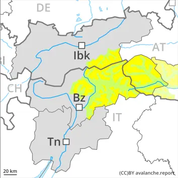
Winter sport participants can release avalanches in isolated cases. These can reach large size in isolated cases. The avalanche prone locations are to be found in particular on very steep west, north and east facing slopes above approximately 2000 m. Caution is to be exercised in particular at transitions from a shallow to a deep snowpack, when entering gullies and bowls for example. As the day progresses the likelihood of wet snow slides being released will increase a little below approximately 2000 m.
Snowpack
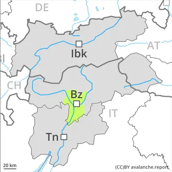
dp.7: snow-poor zones in snow-rich surrounding
Above approximately 2000 m: Avalanche prone weak layers exist in the bottom section of the snowpack on west, north and east facing slopes. Towards its surface, the snowpack consists of faceted crystals. This applies on shady slopes.
Below approximately 2000 m and steep sunny slopes: The old snowpack will be moist. The surface of the snowpack will freeze very little and will already be soft in the early morning. The spring-like weather conditions will give rise to gradual and thorough wetting of the snowpack at low and intermediate altitudes.
Tendency
Weakly bonded old snow requires caution.
5 to 10 cm of snow, and even more in some localities, will fall until Sunday. Fresh wind slabs are in isolated cases prone to triggering on near-ridge shady slopes. On very steep sunny slopes moist loose snow slides are to be expected.
Danger level
2000m
Avalanche Problem
Persistent weak layer
2000m
Weakly bonded old snow requires caution.
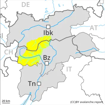
Winter sport participants can release avalanches in isolated cases. These can reach large size in isolated cases. The avalanche prone locations are to be found in particular on very steep west, north and east facing slopes above approximately 2000 m. Caution is to be exercised in particular at transitions from a shallow to a deep snowpack, when entering gullies and bowls for example.
Snowpack
dp.7: snow-poor zones in snow-rich surrounding
Above approximately 2000 m: Avalanche prone weak layers exist in the bottom section of the snowpack on west, north and east facing slopes. Towards its surface, the snowpack consists of faceted crystals. This applies on shady slopes.
Below approximately 2000 m and steep sunny slopes: The old snowpack will be moist. The surface of the snowpack will freeze very little and will already be soft in the early morning.
Tendency
Weakly bonded old snow represents the main danger.
10 to 20 cm of snow, and even more in some localities, will fall until Sunday. Fresh wind slabs are in some cases prone to triggering on near-ridge shady slopes. In addition mostly small moist loose snow avalanches are to be expected, in the event of prolonged bright spells in particular on very steep sunny slopes.
Danger level
2000m
Avalanche Problem
Persistent weak layer
2000m
Weakly bonded old snow requires caution.
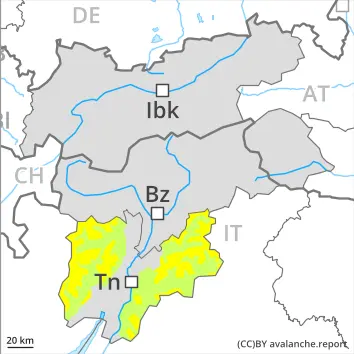
Weakly bonded old snow requires caution. Avalanches can be released in the old snowpack, even by a single winter sport participant. They can in isolated cases release deeper layers of the snowpack and reach quite a large size. Avalanche prone locations are to be found especially above approximately 2000 m. These avalanche prone locations are to be found in particular in northwest to north to northeast facing aspects. Caution is to be exercised in particular on steep shady slopes, as well as at transitions from a shallow to a deep snowpack, when entering gullies and bowls for example.
In the late morning the likelihood of slab avalanches being released will increase in particular on steep south and southwest facing slopes below the tree line.
As a consequence of warming during the day individual mostly small wet loose snow avalanches are possible.
Snowpack
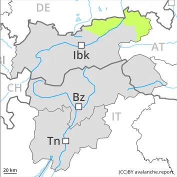
dp.1: deep persistent weak layer dp.10: springtime scenario
Shady slopes: Distinct weak layers exist in the bottom section of the snowpack in particular on northwest, north and northeast facing slopes. This applies especially above approximately 2000 m.
Outgoing longwave radiation during the night was reduced over a wide area. Below approximately 2000 m and steep sunny slopes: The old snowpack will be moist. The surface of the snowpack will freeze very little and will already be soft in the early morning.
In some localities 2 to 5 cm of snow will fall in the late morning, especially above approximately 1800 m.
Tendency
Over a wide area 15 to 30 cm of snow, and even more in some localities, will fall until Sunday. The strong wind will transport the new snow. Fresh wind slabs are prone to triggering on steep shady slopes. The avalanche danger will increase.
Danger level
Weak layers in the old snowpack can be released in isolated cases.
Avalanches can in isolated cases be released in the old snowpack and reach medium size in isolated cases on northwest, north and northeast facing slopes. They can be released, even by a single winter sport participant. As a consequence of warming during the day individual mostly small wet loose snow avalanches are possible.
Snowpack
dp.10: springtime scenario dp.1: deep persistent weak layer
Shady slopes: Avalanche prone weak layers exist in the old snowpack on northwest, north and northeast facing slopes. This applies especially above the tree line.
Outgoing longwave radiation during the night was reduced. The weather conditions during the course of the night gave rise to slight moistening of the snowpack.
In some localities 2 to 5 cm of snow will fall in the late morning, especially above approximately 1800 m.
Tendency
Over a wide area 15 to 25 cm of snow, and even more in some localities, will fall above approximately 1600 m. The strong wind will transport the new snow. Fresh wind slabs are in isolated cases prone to triggering. Weakly bonded old snow requires caution. The avalanche danger will increase. Over a wide area 15 to 30 cm of snow, and even more in some localities, will fall until Sunday. The strong wind will transport the new snow. Fresh wind slabs are prone to triggering on steep shady slopes. The avalanche danger will increase.
Danger level
Low avalanche danger will prevail.
Only isolated dry avalanches are possible. They can be released, in particular by large loads, but they will be small in most cases. Individual avalanche prone locations are to be found on steep shady slopes at high altitude.
Snowpack
dp.10: springtime scenario
Shady slopes: Avalanche prone weak layers exist in the old snowpack in particular on northwest, north and northeast facing slopes.
Sunny slopes: The weather conditions gave rise to moistening of the snowpack.
Tendency
Low avalanche danger will prevail. Some snow will fall.
Danger level
A generally favourable avalanche situation will prevail.
Individual avalanche prone locations for dry avalanches are to be found in particular on very steep shady slopes above approximately 2000 m. Mostly avalanches are small. Apart from the danger of being buried, restraint should be exercised in particular in view of the danger of avalanches sweeping people along and giving rise to falls.
Snowpack
Above approximately 2000 m: Isolated avalanche prone weak layers exist in the bottom section of the snowpack on northwest, north and northeast facing slopes. In steep terrain there is a danger of falling on the hard snow surface.
Below approximately 2000 m: The old snowpack will be moist. The weather conditions as the day progresses will give rise to gradual softening of the snowpack. This also applies on steep sunny slopes above approximately 2000 m.