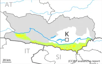
Weakly bonded old snow on northwest, north and northeast facing slopes.
Avalanches can in isolated cases be released by small loads and reach medium size. This applies in particular above approximately 1900 m on very steep northwest, north and northeast facing slopes. Such avalanche prone locations are barely recognisable. Caution is to be exercised in particular at transitions from a shallow to a deep snowpack, when entering gullies and bowls for example.
As the day progresses the likelihood of wet snow slides being released will increase below approximately 1900 m.
Snowpack
dp.7: snow-poor zones in snow-rich surrounding
Some snow will fall in some regions.
Above approximately 1900 m: Weak layers exist in the bottom section of the snowpack on northeast, north and northwest facing slopes.
Below approximately 1900 m and steep sunny slopes: The old snowpack will be moist. The weather conditions will give rise to thorough wetting of the snowpack at low and intermediate altitudes.
Tendency
Weakly bonded old snow requires caution.
Danger level
2000m
Avalanche Problem
Persistent weak layer
2000m
Wind slab
2200m
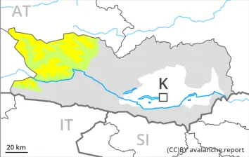
Wind slabs and weakly bonded old snow require caution.
Avalanches can in isolated cases be released in the old snowpack and reach large size in isolated cases. This applies in case of a single winter sport participant. The avalanche prone locations are to be found in particular on very steep west, north and east facing slopes above approximately 2000 m. They are barely recognisable. Caution is to be exercised in particular at transitions from a shallow to a deep snowpack, when entering gullies and bowls for example.
In addition the fresh wind slabs are prone to triggering in some locations. This applies especially adjacent to ridgelines and in pass areas on shady slopes above approximately 2200 m. These can be released by a single winter sport participant, but they will be small in most cases.
As the day progresses moist loose snow avalanches are possible. This applies on very steep slopes, and at the base of rock walls, in the event of solar radiation in particular.
Snowpack
dp.7: snow-poor zones in snow-rich surrounding dp.6: cold, loose snow and wind
Some snow has fallen. Up to 10 cm of snow, and even more in some localities, will fall until late morning.
The fresh wind slabs will be deposited on the unfavourable surface of an old snowpack in particular on shady slopes at elevated altitudes.
Above approximately 2000 m: Avalanche prone weak layers exist in the bottom section of the snowpack on west, north and east facing slopes. Towards its surface, the snowpack consists of faceted crystals. This applies on shady slopes.
Below approximately 2000 m and steep sunny slopes: The old snowpack will be moist. The weather conditions will give rise to thorough wetting of the snowpack at low and intermediate altitudes.
Tendency
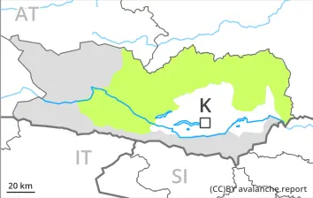
Wind slabs and weakly bonded old snow require caution.
As a consequence of new snow and wind from southerly directions, sometimes avalanche prone wind slabs will form in particular adjacent to ridgelines and in pass areas. This applies especially on shady slopes above approximately 1900 m. The fresh wind slabs can be released by a single winter sport participant and reach medium size.
Additionally in isolated cases avalanches can also be released in the old snowpack and reach large size in isolated cases. This applies in case of a single winter sport participant. The avalanche prone locations are to be found in particular on very steep west, north and east facing slopes above approximately 2000 m. They are barely recognisable. Caution is to be exercised in particular at transitions from a shallow to a deep snowpack, when entering gullies and bowls for example.
As the day progresses moist loose snow avalanches are to be expected. This applies on very steep slopes, as well as at the base of rock walls, in the event of solar radiation in particular.
Snowpack
dp.6: cold, loose snow and wind dp.7: snow-poor zones in snow-rich surrounding
Some snow has fallen. In particular along the border with Italy up to 20 cm of snow, and even more in some localities, will fall until late morning.
The fresh wind slabs will be deposited on the unfavourable surface of an old snowpack in particular on shady slopes at elevated altitudes.
Above approximately 2000 m: Avalanche prone weak layers exist in the bottom section of the snowpack on west, north and east facing slopes. Towards its surface, the snowpack consists of faceted crystals. This applies on shady slopes.
Below approximately 2000 m and steep sunny slopes: The old snowpack will be moist. The weather conditions will give rise to thorough wetting of the snowpack at low and intermediate altitudes.
Tendency
Wind slabs and weakly bonded old snow require caution.
Danger level
1900m
Avalanche Problem
Persistent weak layer
1900m
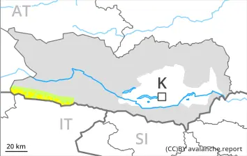
Low avalanche danger will prevail.
Individual avalanche prone locations are to be found in particular on very steep shady slopes above approximately 1900 m. In very isolated cases avalanches are medium-sized.
As the day progresses the likelihood of wet snow slides being released will increase below approximately 1900 m.
Snowpack
dp.1: deep persistent weak layer
Some snow will fall in some regions.
Above approximately 1900 m: Weak layers exist in the bottom section of the snowpack on northeast, north and northwest facing slopes.
Below approximately 1900 m and steep sunny slopes: The old snowpack will be moist. The weather conditions will give rise to thorough wetting of the snowpack at low and intermediate altitudes.