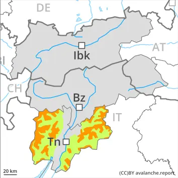
Wind slabs and weakly bonded old snow require caution.
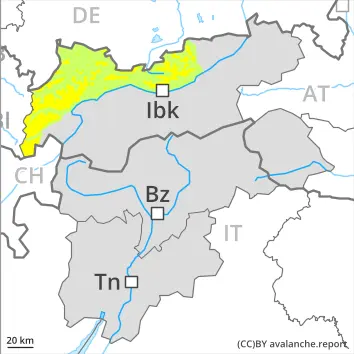
As a consequence of new snow and a strong to storm force northerly wind, extensive wind slabs formed in the last few days in all aspects. As a consequence of new snow and a light to moderate northerly wind, further wind slabs will form on Monday. Adjacent to ridgelines and in gullies and bowls and on steep slopes dry slab avalanches are possible. Avalanches can be released by small loads. This applies in particular above the tree line, as well as at transitions from a shallow to a deep snowpack, when entering gullies and bowls for example.
Precarious weak layers exist in the old snowpack on very steep shady slopes. These avalanche prone locations are to be found in particular in east to north to west facing aspects. Medium-sized avalanches are possible especially adjacent to ridgelines and in gullies and bowls. These can release deeper layers of the snowpack.
Snowpack
dp.6: cold, loose snow and wind dp.1: deep persistent weak layer
The sometimes storm force wind has transported the new snow significantly. As a consequence of a strong to storm force wind from northerly directions, sometimes large wind slabs formed in the last few days in particular in gullies and bowls and behind abrupt changes in the terrain. The fresh wind slabs are lying on the unfavourable surface of an old snowpack in particular on east to north to west facing aspects and generally above the tree line.
Tendency
On Tuesday the wind will be moderate to strong in the regions exposed to the foehn wind.
Danger level
treeline
Avalanche Problem
Wind slab
Treeline
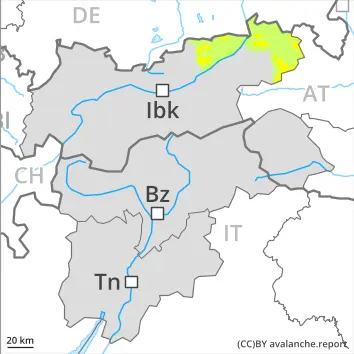
Wind slabs represent the main danger.
The more recent wind slabs represent the main danger. Avalanches can penetrate down to the ground and reach medium size, caution is to be exercised in particular adjacent to ridgelines and in gullies and bowls.
Snowpack
dp.6: cold, loose snow and wind dp.1: deep persistent weak layer
The sometimes storm force wind has transported the new snow significantly. As a consequence of a strong to storm force wind from northerly directions, sometimes large wind slabs formed in the last few days in particular in gullies and bowls and behind abrupt changes in the terrain. The fresh wind slabs are lying on the unfavourable surface of an old snowpack in all aspects and generally above the tree line.
Tendency
On Tuesday the wind will be moderate to strong in the regions exposed to the foehn wind.
Danger level
2200m
Avalanche Problem
Wind slab
2200m
Persistent weak layer
2200m
Wind slabs represent the main danger. Weakly bonded old snow is to be evaluated with care and prudence.
As a consequence of new snow and a storm force northerly wind, extensive wind slabs formed in all aspects. These can be released even by a single winter sport participant above approximately 2200 m, caution is to be exercised in particular at the base of rock walls and behind abrupt changes in the terrain, as well as adjacent to ridgelines and in gullies and bowls. Mostly avalanches are medium-sized.
Additionally in isolated cases avalanches can penetrate near-ground layers of the snowpack and reach large size in isolated cases, especially on west, north and east facing slopes above approximately 2200 m, and on south facing slopes at elevated altitudes.
Whumpfing sounds and the formation of shooting cracks when stepping on the snowpack can indicate the danger.
Snowpack
dp.6: cold, loose snow and wind dp.1: deep persistent weak layer
The sometimes storm force wind has transported the fresh and old snow significantly. In some cases the various wind slabs have bonded still only poorly together.
The old snowpack will be weakly bonded in some places, especially on west, north and east facing slopes above approximately 2200 m, and on south facing slopes at elevated altitudes.
Tendency
10 to 30 cm of snow, and even more in some localities, will fall. As a consequence of new snow and a sometimes strong wind from northerly directions, further wind slabs will form.
Danger level
2200m
Avalanche Problem
Persistent weak layer
2200m
Wind slab
2200m
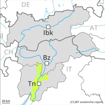
Weakly bonded old snow is to be avoided. Wind slabs require caution.
Winter sport participants can release avalanches in isolated cases. They can be triggered in deep layers and reach medium size. Caution is to be exercised in particular on very steep west, north and east facing slopes above approximately 2200 m, and on south facing slopes at elevated altitudes. Especially transitions from a shallow to a deep snowpack are unfavourable.
Wind slabs can still be released at elevated altitudes. This applies in particular in case of a large load. Avalanche prone locations are to be found in particular in gullies and bowls, and behind abrupt changes in the terrain. Avalanches can reach medium size in isolated cases.
Snowpack
dp.7: snow-poor zones in snow-rich surrounding dp.6: cold, loose snow and wind
The old snowpack will be weakly bonded, especially on west, north and east facing slopes above approximately 2200 m, and on south facing slopes at elevated altitudes.
The sometimes storm force wind has transported the fresh and old snow significantly. Hard wind slabs formed. The various wind slabs have bonded quite well together.
Tendency
Weakly bonded old snow requires caution.
Danger level
treeline
Avalanche Problem
New snow
Treeline
Persistent weak layer
2200m
New snow and weakly bonded old snow are to be assessed with care and prudence.
The large quantity of fresh snow and the extensive wind slabs can be released easily, even by a single winter sport participant, above the tree line. The wind slabs of the last few days are covered with new snow and therefore barely recognisable. Mostly avalanches are medium-sized.
Avalanches can in some cases penetrate near-ground layers of the snowpack and reach large size, especially on steep west, north and east facing slopes above approximately 2200 m.
In addition gliding avalanches are possible, especially on cut and grassy slopes below approximately 2400 m.
Snowpack
dp.6: cold, loose snow and wind dp.1: deep persistent weak layer
In some cases the various wind slabs have bonded still only poorly together.
The old snowpack will be weakly bonded in some places, especially on west, north and east facing slopes above approximately 2200 m, and on south facing slopes at elevated altitudes.
Tendency
Over a wide area 30 to 40 cm of snow, and even more in some localities, will fall. The wind will be strong in some cases. Further wind slabs will form.
Danger level
treeline
Avalanche Problem
Wind slab
Treeline
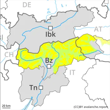
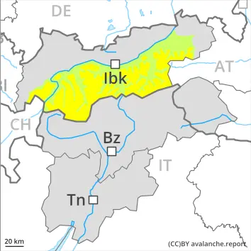
Wind slabs are to be avoided.
The wind slabs of the last few days can be released by a single winter sport participant in some cases above the tree line, in particular adjacent to ridgelines and in gullies and bowls.
Additionally in isolated cases avalanches can penetrate near-ground layers of the snowpack reach medium size, especially on shady slopes at elevated altitudes.
Snowpack
dp.6: cold, loose snow and wind dp.1: deep persistent weak layer
The wind has transported the new snow significantly. In some cases the various wind slabs have bonded still only poorly together.
Isolated avalanche prone weak layers exist in the old snowpack, especially on shady slopes.
Tendency
Over a wide area 10 to 20 cm of snow, and even more in some localities, will fall. The wind will be strong in some cases. Further wind slabs will form.
Danger level
2200m
Avalanche Problem
Persistent weak layer
2200m
Wind slab
2200m
Wind slabs and weakly bonded old snow represent the main danger.
In some places avalanches can be released in the old snowpack and reach large size in isolated cases, especially on west, north and east facing slopes above approximately 2200 m, and on south facing slopes at elevated altitudes. Whumpfing sounds and the formation of shooting cracks when stepping on the snowpack can indicate the danger. Remotely triggered avalanches are possible in isolated cases.
The fresh and older wind slabs can be released by a single winter sport participant in some cases above approximately 2200 m. Such avalanche prone locations are sometimes covered with new snow and are therefore difficult to recognise, caution is to be exercised in particular at the base of rock walls and behind abrupt changes in the terrain, as well as adjacent to ridgelines and in gullies and bowls. Mostly avalanches are medium-sized.
Snowpack
dp.6: cold, loose snow and wind dp.4: cold following warm / warm following cold
The sometimes storm force wind has transported the fresh and old snow significantly. In some cases the various wind slabs have bonded still only poorly together.
The old snowpack will be weakly bonded in some places, especially on west, north and east facing slopes above approximately 2200 m, and on south facing slopes at elevated altitudes.
Tendency
Weakly bonded old snow is to be evaluated with care and prudence. Over a wide area 20 to 30 cm of snow, and even more in some localities, will fall. The wind will be moderate over a wide area. Avalanche prone wind slabs will form.
Danger level
treeline
Avalanche Problem
Wind slab
Treeline
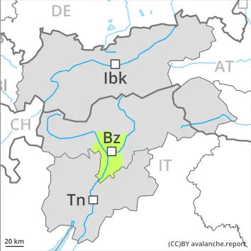
Fresh wind slabs are to be evaluated with care and prudence.
Wind slabs are in some cases prone to triggering in particular on west to north to east facing aspects above the tree line. Avalanches can in very isolated cases penetrate near-ground layers of the snowpack and reach medium size.
Snowpack
dp.6: cold, loose snow and wind dp.1: deep persistent weak layer
The wind was storm force in some cases. The northwesterly wind has transported some snow. Avalanche prone wind slabs formed.
Tendency
Fresh wind slabs are to be evaluated with care and prudence.